Mitla
The Zapotec city of the dead — with stone mosaic geometric decoration unique in all of pre-Columbian America, and a colonial church built directly into its ruins.
At a glance
Forty-six kilometres east of Oaxaca city in the valley of the Río Grande, Mitla was the religious capital and necropolis of the Zapotec civilisation — the counterpart to Monte Albán’s political role. Its Zapotec name, Lyobaa, means Place of Rest; the Nahuatl name Mitla means Place of the Dead. While Monte Albán commanded the civic and military landscape, Mitla was where Zapotec priests and rulers were interred, and where the highest Zapotec religious official — described by Spanish sources as a figure of near-papal authority — presided over the cult of the dead from at least 750 AD until the Spanish conquest in 1521. What makes Mitla extraordinary — unique in all the ancient Americas — is the decoration on its walls: thousands of small, precisely cut stone tesserae set into the plaster in complex geometric patterns without mortar, creating panels of abstract fret designs of astonishing precision and variety.
Key facts
- Culture: Zapotec (primary); Mixtec influence in later phases
- Occupied: c. 750–1521 AD at its apex; earlier occupation from Classic period
- Function: Religious capital and elite necropolis; residence of the Zapotec high priest of death
- Unique feature: Stone mosaic greca panels — thousands of cut stone tesserae in geometric patterns, no mortar, no figurative imagery — unique in pre-Columbian America
- Key complex: The Columns Group (Grupo de las Columnas) — best preserved and most elaborately decorated
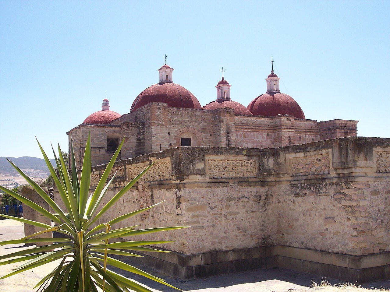
- Colonial intrusion: Church of San Pablo Apóstol (16th c.) built partly over and from the stones of the main palace
- Distance from Oaxaca city: 46 km east, approximately 45 minutes by road
History
The Zapotec civilisation, one of the earliest urban cultures in Mesoamerica, developed in the Valley of Oaxaca from around 500 BC, with Monte Albán as its capital. By the post-Classic period (after 700 AD), as Monte Albán declined, Mitla rose to prominence as the primary religious centre. Spanish chronicles from the 16th century describe a religious hierarchy at Mitla topped by a figure they called the Great Seer or High Priest of Death — a sacerdotal ruler who dressed in black, never cut his hair or nails, and was considered so sacred that he was treated as a living god. When this figure died, he was interred in one of Mitla’s underground tomb chambers. After the Spanish conquest (1521 in the Oaxaca region), the Dominicans systematically dismantled the religious structures and incorporated their stones into the colonial church of San Pablo Apóstol, which was built literally on top of and adjacent to the Columns Group palace. The colonial church still stands today, its foundations incorporating Zapotec stonework.
What you see
Mitla consists of five palace complexes arranged around plazas. The Columns Group is the centrepiece: a double courtyard complex with a large hall supported by six monolithic cylindrical columns (each cut from a single stone, approximately 4 metres tall), surrounded on all sides by the extraordinary mosaic wall panels. These panels — called greca in Spanish colonial sources — are entirely abstract: stepped spirals, interlocking T-shapes, zigzag meanders, and geometric fret patterns, each panel different from the next, covering every vertical surface from floor to ceiling. The tesserae are cut with extraordinary precision: fit together with tolerances of a few millimetres and virtually no visible mortar joints, the surface is flush despite being composed of thousands of individual pieces. Some panels contain up to 14 distinct geometric variants within a single design.
Underground tomb chambers are accessible via narrow passageways descending beneath the palace floors. The chambers have corbelled stone ceilings and were used for elite interments; a massive stone cylinder in one chamber (La Columna de la Vida) was used, according to tradition, to measure a person’s remaining lifespan. The colonial church of San Pablo sits adjacent to and partially over the main complex; the transition between Zapotec stonework and Spanish colonial construction is visible at several points.
Practical information
- Open: Daily 08:00–17:00
- Admission: INAH entrance fee; combined with small site museum
- On site: Good footpaths; the underground tombs involve ducking through low passages
- Village of Mitla: Adjacent to the ruins, with restaurants, artisan markets (locally woven textiles and mezcal), and the colonial church of San Pablo
- Best time: Morning for light on the greca panels; the site is not heavily visited compared to Monte Albán
- Photography: Permitted; the greca panels photograph exceptionally well in raking side-light
Getting there
Mitla is 46 km east of Oaxaca city on the Carretera 190 (Pan-American Highway). By car: approximately 45 minutes. By bus: second-class buses and colectivos (shared vans) depart from the second-class bus terminal in Oaxaca (Terminal de Autobuses de Segunda Clase) for Mitla frequently throughout the day; journey approximately 1 hour. The site is commonly combined with the archaeological site of Yagul (10 km west of Mitla) and the El Tule tree (the largest tree in the world by circumference, on the road from Oaxaca) for a full-day Eastern Valley circuit.
Nearby
- Yagul (~10 km west) — Zapotec and Mixtec hilltop fortress with a ball court larger than any at Mont Albán, and extraordinary valley views; UNESCO WHS with Mitla as part of the Central Valleys of Oaxaca
- El Tule (~38 km west toward Oaxaca) — the Montezuma cypress with the world’s largest trunk circumference (nearly 60 metres), over 2,000 years old, standing in a village churchyard
- Monte Albán (~40 km west) — the Zapotec civic and military capital, with pyramid platforms, carved stelae of Dancers, and panoramic Valley of Oaxaca views
- Oaxaca city (~46 km west) — colonial city and gastronomic capital, with the Santo Domingo church and the Museo de las Culturas de Oaxaca
Sources
- Byland, B.E. & Pohl, J.M.D. (1994). In the Realm of 8 Deer: The Archaeology of the Mixtec Codices. University of Oklahoma Press.
- Flannery, K.V. & Marcus, J. (1983). The Cloud People: Divergent Evolution of the Zapotec and Mixtec Civilizations. Academic Press.
- Caso, A. (1935). Las exploraciones en Oaxaca, quinta y sexta temporadas. Instituto Panamericano de Geografía e Historia.
- Wikipedia: Mitla
Find it on the map
See this place and what’s around it →📷 Diventa un fotografo di Cultural Heritage Online
Condividi le tue foto dei luoghi: restano pubblicate con la tua firma come autore. Più vengono viste, più ti fai conoscere — e presto un concorso premierà le foto più apprezzate.
Accedi o registrati gratis per aggiungere una foto