The Site at a Glance
- Location
- Yarnaz Valley, Turpan, Xinjiang, China
- Period
- c. 108 BC – 450 AD (Han Dynasty to early Tang Dynasty)
- Construction method
- Carved downward from a natural loess plateau — not built upward
- Plateau height
- 30 metres above the surrounding valley
- Wall survival
- Standing to 8+ metres in places
- UNESCO World Heritage
- 2014 (as part of the Silk Roads)
- Meaning of name
- “Confluence of rivers” (Chinese)
A City Carved Downward — The Unique Construction Method
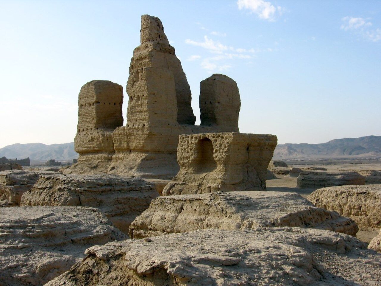
Jiaohe is structurally unlike any other ancient city on earth. Builders did not construct walls and stack stones or bricks to create structures — they did the opposite. Starting with a natural elongated mesa of compacted loess rising 30 metres above the Yarnaz Valley floor, they carved the city downward from the plateau surface. Streets are deep trenches cut vertically into the earth. Rooms are chambers excavated into the sides of those trenches. Buddhist monasteries are large depressions with facades of unexcavated loess columns left standing as pillars. The buildings are not architecture built up — they are the solid plateau itself, with everything else removed.
The result is a city of extraordinary visual drama: narrow streets dropping 3–5 metres below the plateau surface, flanked by earthen walls that are simply the unexcavated body of the mesa. Nothing was transported, quarried, or fired. The building material was the site itself. And because compacted loess is extremely stable in arid conditions, those walls are still standing today — two millennia later.
The Natural Fortress — Cliffs on Every Side
The plateau’s shape made Jiaohe a natural fortress. The mesa is roughly elongated, with sheer cliff faces on all sides dropping into two river channels that converge below — giving the city its Chinese name, Jiaohe, meaning “confluence of rivers.” Access to the city is possible only via two narrow paths at the north and south ends; the cliffs render every other approach impassable.
No walls or defensive fortifications were needed and none were built. The cliff faces themselves were the city’s walls. This natural defensive advantage is why the site was chosen for a Han military garrison: any attacking force had to approach by one of two chokepoints, channelled into narrow paths where a small defending force could hold indefinitely.
Silk Road Garrison and Administrative Centre
The city served as a Western Han Chinese military and administrative garrison controlling the northern branch of the Silk Road through the Tarim Basin. It was the seat of the Han Chinese commandery governing the Turpan oasis — one of the critical way-stations on the trade routes connecting China, Central Asia, Persia, and Rome.
The city housed soldiers, administrators, merchants, Buddhist monks, and their families. The Buddhist monastery complex at the northern end of the plateau is among the best-preserved elements — a large rectilinear compound of excavated cells, meditation chambers, and colonnaded halls. Votive objects, manuscripts in multiple scripts (Chinese, Sogdian, Uyghur, Sanskrit), coins, and textile fragments have been excavated here, forming a physical index of the Silk Road’s cultural mixing.
Preservation by Aridity — The Driest Place in China
Jiaohe survives because of where it is. The Turpan Depression is the driest place in China and one of the driest on earth — annual precipitation is under 16 mm. The compacted loess from which the city is carved does not dissolve in the absence of rain. Walls that in any other climate would have eroded within centuries are still standing at 8+ metres. The arid conditions also preserved organic material: wooden beams, textile fragments, and paper manuscripts have been found intact.
By contrast, Chan Chan in Peru — also an adobe city, also a UNESCO World Heritage Site in Danger — is being dissolved by El Niño rains. Jiaohe faces no such threat from precipitation. Its conservation challenges are primarily seismic (the Turpan region experiences earthquakes) and touristic (visitor foot traffic erodes the excavated floor surfaces).
Abandonment — Mongol Invasion and Agricultural Collapse
Jiaohe was occupied continuously from the Han period through to the early Tang Dynasty, with the population peaking during the Tang (7th–8th centuries AD) when Turpan was fully integrated into the Tang empire. The city began to decline when Tang imperial power retreated from Central Asia in the 750s–760s, ceding the region to Tibetan and later Uyghur control.
The final blow came with the Mongol invasions of the 13th–14th centuries, which destroyed the karez irrigation system — the ancient network of underground channels that brought snowmelt from the Tian Shan mountains to the Turpan oasis. Without irrigation the surrounding agriculture collapsed, making the city uninhabitable. Jiaohe was abandoned around the 14th century and never reoccupied, which is why it survives intact: no later populations dismantled or built over it.
Visiting Jiaohe Today
Jiaohe is located approximately 10 km west of Turpan city in Xinjiang, China. The site is open year-round; the best visiting seasons are spring (April–May) and autumn (September–October) — summer temperatures in the Turpan Depression regularly exceed 45 °C, making outdoor archaeological sites almost inaccessible from June to August.
The site path follows the central street trench from south to north across the plateau, passing residential quarters, government buildings, the central Buddhist pagoda mound, and ending at the monastery complex at the north end. Raised boardwalks protect the most fragile excavated surfaces. Photography is permitted throughout. The nearest major city is Turpan (Tulufan), which has a fast-train station connected to Urumqi (2 hours) and Xi’an (10 hours).
Location & GPS
Jiaohe: 42.9222°N, 89.0539°E. Yarnaz Valley, Turpan (Tulufan), Xinjiang, China. ~10 km west of Turpan city centre.
[cho_mini_map lat=”42.9222″ lng=”89.0539″ zoom=”13″ label=”Jiaohe Ruins”]
Find it on the map
See this place and what’s around it →📷 Diventa un fotografo di Cultural Heritage Online
Condividi le tue foto dei luoghi: restano pubblicate con la tua firma come autore. Più vengono viste, più ti fai conoscere — e presto un concorso premierà le foto più apprezzate.
Accedi o registrati gratis per aggiungere una foto