

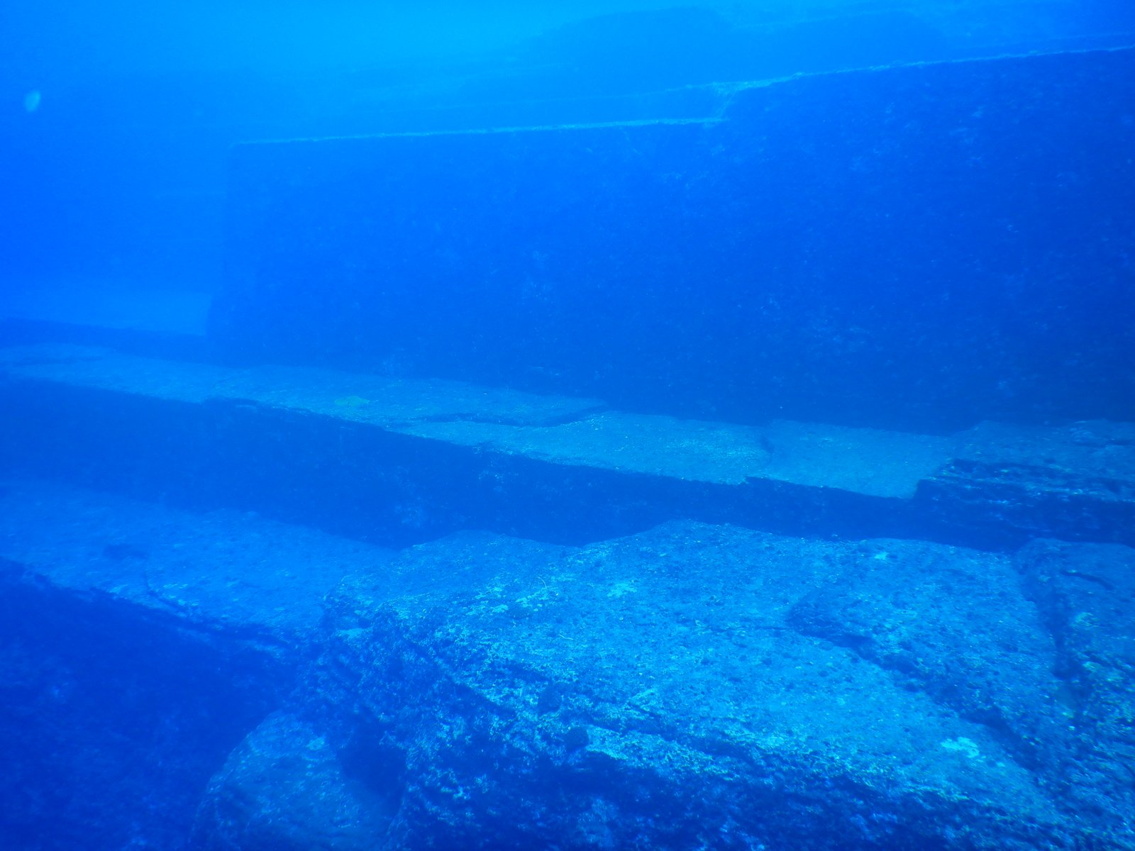
A massive formation of stepped terraces, flat planes, and sharp angles on the seabed near Japan’s westernmost island, the Yonaguni Monument has divided geologists since its discovery in 1986 — is it a natural wonder of Miocene sandstone, or the remnant of an ancient civilisation?
At a glance
The Yonaguni Monument lies approximately 100 metres off the southern shore of Yonaguni Island, the westernmost island of Japan’s Ryukyu archipelago, at depths ranging from the surface to 40 metres. The main formation measures roughly 150 metres east–west and 40 metres north–south, rising from the lowest point at 40 metres to a summit platform at about 5 metres depth. It was discovered by local dive operator Kihachiro Aratake in 1986 while scouting routes for diving tours. The site has been the subject of active scientific debate ever since: Masaaki Kimura of Ryukyu University has argued for a human-made origin dating to 2000 BC or earlier, while geologist Robert Schoch and others contend the formation is a natural geological feature shaped by coastal erosion of Miocene-era mudstone.
Key facts
- Period: Geological age: Miocene (c. 20 million years); if man-made, proposed date c. 2000 BC or older (disputed)
- Discovery: 1986–1987, Kihachiro Aratake (dive operator, Yonaguni)
- Depth / Scale: 5–40 metres; main structure 150 m × 40 m, rises approx. 27 metres from base
- Status: No formal heritage designation; managed as a dive site by local operators
- Access: Open recreational diving; strong currents require advanced certification for the deepest sections
History
Kihachiro Aratake first encountered the formation in 1986 while looking for hammerhead shark aggregation sites off the southern tip of Yonaguni. He reported his find to Japanese dive media in 1987, and the site quickly attracted academic and popular attention. The first systematic scientific examination was conducted by Masaaki Kimura, a marine seismologist at Ryukyu University, who began annual surveys in the early 1990s. Kimura catalogued features he identified as tooling marks, carved steps, a “road” running along the base of the formation, a triangular “pool”, and what he described as a “stadium” — a wide flat area flanked by regular vertical faces. He proposed that the structure dated to at least 2000 BC and represented a monument of the Jōmon culture, the prehistoric inhabitants of the Japanese archipelago.
The counter-argument was made most forcefully by Robert Schoch, a Boston University geologist who had previously reanalysed the Sphinx at Giza. After diving the site in 1997, Schoch concluded that all observed features — the right angles, the flat terraces, the parallel grooves — could be explained by the natural jointing and erosion of a fine-grained Miocene mudstone that tends to fracture along regular planes. He noted the absence of any confirmed worked stone tools, carvings with iconographic content, or organic materials that could be dated.
No consensus has been reached. The debate turns in part on the question of sea levels: if the formation was at or near the surface around 8000–10000 BC (when global sea levels were significantly lower), a Jōmon-period origin is not geologically impossible. What is beyond dispute is that the structure, whatever its origin, is extraordinary — and that diving it is an experience unlike any other in Japan.
What you see
Descending to the monument, divers first encounter the main terrace — a horizontal platform roughly 20 metres below the surface, its edge a sheer vertical drop of 5 metres that seems too regular to be accidental. The surface of the platform is smooth mudstone, scored by parallel cracks running at approximately 45 degrees. At the north-eastern end, a series of wide steps descends toward the deeper sections, each riser approximately 1 metre tall, each tread 3–4 metres wide. In open water, with strong currents pulling along the face of the structure and hammerhead sharks occasionally moving in the blue water above, the scale registers as genuinely monumental.
The deeper sections include a triangular indentation that Kimura called the “pool” and a series of sharp right-angle corners that represent the crux of the debate: natural jointing in mudstone can produce right angles, but the density and regularity of the corners here is striking. At the base of the formation, 40 metres down, a flat sand corridor runs along the entire south face — a feature Kimura termed “the road.” Surface swimmers above the summit platform, at 5 metres, can look straight down through clear water to see the terraced geometry below, and in calm conditions the upper steps are visible from a kayak on the surface.
Practical information
- Best time to visit: November–June, when hammerhead sharks aggregate off Yonaguni; July–October brings typhoon risk and reduced visibility
- Access method: Scuba diving from local operators on Yonaguni Island; advanced open-water certification required; currents can be strong
- Duration: 45–60 minutes per dive; most visitors complete 2–3 dives per day over multiple visits
- Advance booking: Dive packages available through operators in Yonaguni village; accommodation options are limited on the island — book early for peak season
Getting there
Yonaguni Island is served by Japan Air Commuter flights from Naha (Okinawa main island) and Ishigaki, with journey times of approximately 30 minutes. Naha Airport connects to Tokyo Haneda and Osaka Kansai. From Yonaguni Airport, the dive operators are a 5–10 minute drive to the southern coast where the monument is located.
Nearby
- Hammerhead shark diving off Cape Irizaki, Yonaguni’s westernmost point — world-class pelagic diving site
- Iriomote Island — dense subtropical jungle, mangrove kayaking, and rare Iriomote cat habitat, 130 km east
- Ishigaki Island — Kabira Bay glass-bottom boat tours and black pearl farms, 130 km east
Sources
- Wikipedia: https://en.wikipedia.org/wiki/Yonaguni_Monument
- Kimura, M. (2005). “An investigation of the submerged ruins off Yonaguni Island, Japan.” Journal of the Geological Society of Japan.
- Schoch, R. M. (1999). Voices of the Rocks. Harmony Books.
Find it on the map
See this place and what’s around it →📷 Become a Cultural Heritage Online photographer
Share your photos of places: they stay published under your name as the author. The more they're seen, the more you get noticed — and soon a contest will reward the most appreciated photos.
Log in or sign up free to add a photoIs this page about you?
This page is read by travellers and heritage enthusiasts who find it on Google. Tell us how you are connected to this place and we will take it from there.