
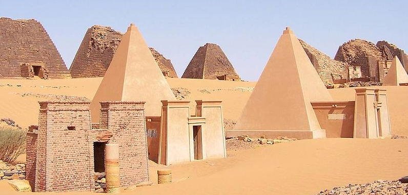
Sudan contains more ancient pyramids than Egypt — approximately 255 known structures versus Egypt’s 118 — and the Meroë necropolis alone accounts for over 200 of them: the steep, narrow monuments of the Kingdom of Kush, a civilisation that ruled the Nile Valley for a thousand years.
At a glance
The ancient city of Meroë, situated on the east bank of the Nile roughly 200 kilometres northeast of present-day Khartoum, served as the capital of the Kingdom of Kush from approximately 300 BC until the kingdom’s collapse around 350 AD. The Kushite rulers borrowed the pyramid form from their Egyptian neighbours but built them steeper — at angles of 65 to 70 degrees compared to Egypt’s 51 degrees — and smaller, typically standing between 15 and 30 metres tall. Each pyramid was built above a burial chamber cut into the bedrock and entered through a small chapel on the east face. Three major pyramid groups (the North, South, and West cemeteries) are spread across the desert plateau north of the ruins of the royal city, together containing more than 200 structures spanning roughly 700 years of continuous royal burial. The site was inscribed by UNESCO in 2011 as the “Island of Meroë” — a reference to the ancient Greek geographic concept of the territory between the Nile, the Atbara, and the Blue Nile as an island-like enclave.
Key facts
- Period: c. 700 BC – 350 AD (Kingdom of Kush, Meroitic period from c. 300 BC)
- UNESCO inscription: 2011 (Island of Meroë)
- Scale: Over 200 pyramids at Meroë alone; Sudan total ~255 pyramids vs Egypt ~118
- Pyramid dimensions: 15–30 m tall; slope angle 65–70° (steeper than Egyptian)
- Vandalism: Tops of 40+ pyramids demolished in the 1830s by Italian treasure hunter Giuseppe Ferlini
- Writing system: Meroitic script partially decoded; the underlying language remains incompletely understood
- Access: Site open daily; no fixed ticket booth for foreigners at time of publication — arrangements via licensed Sudanese tour operators; entry fees subject to change
History
The Kingdom of Kush had its roots in the earlier Kerma culture of the third millennium BC and rose to become a major regional power, controlling the trade in gold, ivory, ebony, and enslaved people flowing north out of sub-Saharan Africa. The Kushite pharaohs of the 25th Dynasty actually ruled Egypt between approximately 744 and 656 BC — a period known as the “Black Pharaohs” — before being expelled by the Assyrians. The capital then moved progressively southward: from Napata (at the fourth Nile cataract) to Meroë, which offered both access to iron ore for smelting and proximity to the agricultural land of the savannah belt. Iron production became a central pillar of the Meroitic economy; slag heaps from ancient smelting furnaces are visible near the royal city site today.
At the height of the Meroitic period, between approximately 300 BC and 200 AD, the kingdom maintained diplomatic and trade relations with Ptolemaic Egypt, Rome, India, and Arabia. Roman Emperor Augustus sent a punitive expedition to Meroë in 23 BC after Kushite forces raided the Roman province of Egypt; the resulting peace treaty, negotiated at Samos, allowed the Kushites to operate with considerable autonomy on Rome’s southern frontier. The Meroitic royal succession passed through both male and female lines, and several warrior queens — called kandake (the title from which the name “Candace” derives) — ruled in their own right. Queen Amanirenas (r. c. 40–10 BC) led the expedition against the Roman garrison at Aswan and appears in inscriptions celebrating her victory. Meroitic royal women are depicted on temple reliefs at the same scale as male rulers, and several pyramids in the south cemetery belong to queens who were sovereigns rather than consorts.
The kingdom fell around 350 AD when it was defeated by the expanding Aksumite Empire of present-day Ethiopia and Eritrea under King Ezana. Meroitic script, a modified alphabet derived from Egyptian hieroglyphics, continued in use until the kingdom’s collapse; the script was deciphered in 1909 by English Egyptologist Francis Llewellyn Griffith, but the Meroitic language it encodes has resisted full linguistic analysis, and a substantial portion of the inscriptions at the site remain semantically opaque. Meroë was not excavated systematically until the campaigns of John Garstang (1909–1914) and the Sudan Antiquities Service from the 1940s onward.
What you see
The North Cemetery, the largest and best-preserved of the three groups, contains more than 40 pyramids arranged in rough rows across a sandy plateau that rises slightly above the surrounding plain. The structures — built of local sandstone and rubble faced with cut stone — are immediately recognisable for their steep profiles, which give them a narrower, taller silhouette than their Egyptian counterparts. Many are missing their apical sections: in 1834, Italian physician and adventurer Giuseppe Ferlini systematically demolished the upper portions of more than forty pyramids searching for buried treasure. He found jewellery in only one case (the pyramid of Queen Amanishakheto), but the damage was irreversible. Each pyramid’s east face retains a small single-room chapel, its entrance flanked by carved relief panels depicting the deceased ruler before the gods Osiris, Isis, and Anubis. At the North Cemetery, some chapel walls retain traces of painted plaster. The subterranean burial chambers, cut 5 to 12 metres into the bedrock below each pyramid, were looted in antiquity; no intact royal burial has been discovered at Meroë.
Two kilometres south of the pyramid cemeteries, the ruins of the royal city include a bath complex with terracotta pipe infrastructure, a large temple of Amun aligned toward sunrise, and the “Sun Temple” (Naqa, 50 km west of the main city), whose pylon carries reliefs of a lion-headed war deity peculiar to Meroitic religion. The site has no protective fencing over most of its area and receives very few visitors — typically fewer than a hundred per day even in peak season — giving the North Cemetery in particular a quality of solitary grandeur that larger, more visited ancient sites rarely retain.
Practical information
- Opening hours: Site accessible during daylight hours; no fixed visitor infrastructure
- Best time to visit: October–February (temperatures 20–35°C); March–September is extremely hot (40–47°C)
- Duration: 2–3 hours for the North Cemetery and main pyramid field; half day if including the royal city ruins and the museum at the site guardian’s compound
- Tip: Sunrise and late afternoon light cast dramatic shadows across the pyramid fields; the low, flat horizon means both are photogenically clean. The site sits in open desert with no shade — bring water and sun protection.
Getting there
Khartoum International Airport (KRT) is the main entry point for Sudan. Meroë is approximately 200 km north of Khartoum along the Nile Valley road, a journey of roughly 2.5 to 3 hours by car. Public buses run between Khartoum and Shendi (the nearest town, 50 km south of the site); from Shendi, taxis or negotiated rides with local drivers cover the remaining distance. Most visitors to Meroë travel with a licensed Sudanese tour operator, which handles logistics including permits. Access conditions and visa requirements for Sudan have changed frequently; check current Foreign Ministry advisories before travel.
Nearby
- Naqa (50 km southwest) — Meroitic temple complex with a Lion Temple and an Amun temple; notable for reliefs combining Egyptian and local Kushite iconography
- Musawwarat es-Sufra (35 km southwest) — vast Meroitic ceremonial enclosure (“Great Enclosure”) whose function — religious centre? elephant training facility? — remains debated
- Napata / Jebel Barkal (300 km north) — earlier Kushite capital with pyramids and a temple cut into the rock of a distinctive mesa, sacred to the god Amun
- Shendi (50 km south) — modern market town on the Nile with hotels and fuel; the practical base for visiting Meroë
Sources
- Wikipedia, “Meroë” — en.wikipedia.org/wiki/Meroë
- UNESCO World Heritage Centre, “Island of Meroë” — whc.unesco.org/en/list/1336
- Welsby, D.A. (1996). The Kingdom of Kush: The Napatan and Meroitic Empires. British Museum Press.
- Török, L. (1997). The Kingdom of Kush: Handbook of the Napatan-Meroitic Civilization. Brill.
Find it on the map
See this place and what’s around it →📷 Become a Cultural Heritage Online photographer
Share your photos of places: they stay published under your name as the author. The more they're seen, the more you get noticed — and soon a contest will reward the most appreciated photos.
Log in or sign up free to add a photoIs this page about you?
This page is read by travellers and heritage enthusiasts who find it on Google. Tell us how you are connected to this place and we will take it from there.