Village of Pietrapertosa — Virtual Tour 360°
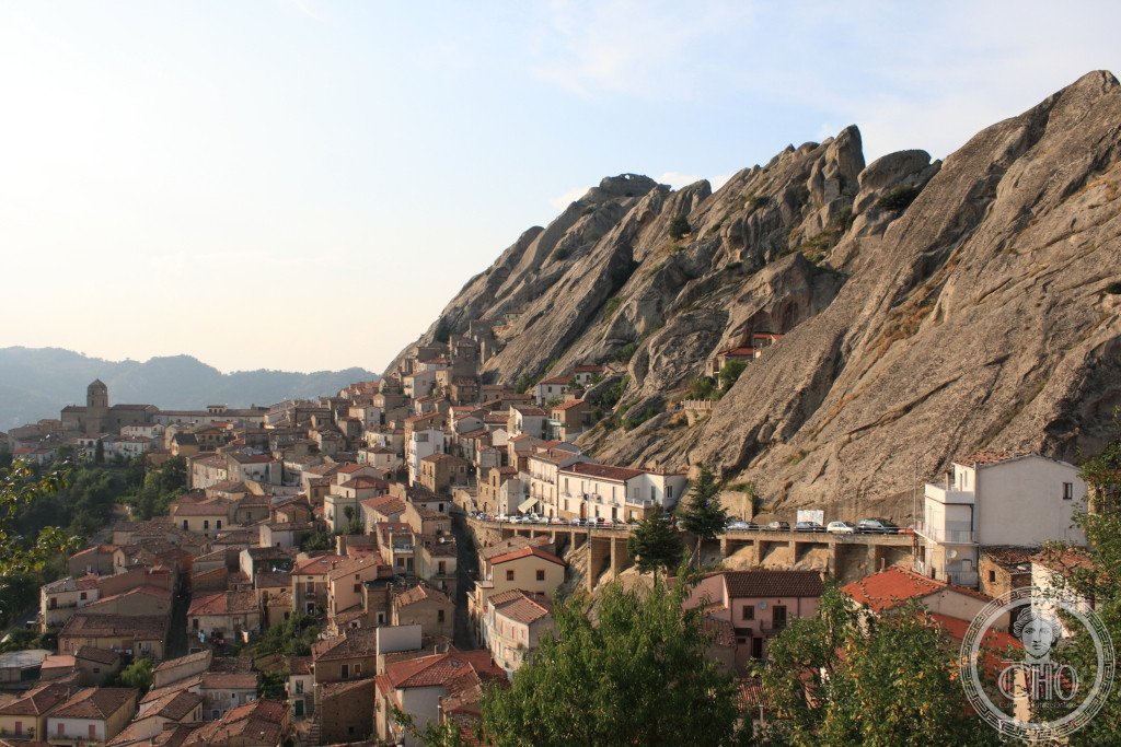
Pietrapertosa is a medieval hilltop village in the province of Potenza, in the Basilicata region of southern Italy. Perched dramatically on the rocky crags of the Lucanian Dolomites at over 1,000 metres above sea level, it is one of the highest villages in the region and one of the most spectacularly situated settlements in all of Italy. Recognised as one of I borghi più belli d’Italia (the most beautiful villages in Italy), Pietrapertosa is also famous for its adventure activity, the Volo dell’Angelo zipline connecting it to the neighbouring village of Castelmezzano.
At a glance
- Type
- Historic hilltop village (borgo)
- Period
- Medieval foundations; pre-Norman Saracen fortifications
- Style
- Rupestrian (cave-dwelling) and medieval stone architecture
- Location
- Province of Potenza, Basilicata, Italy
Overview
Pietrapertosa clings to a dramatic ridge of Lucanian Dolomite limestone at an elevation of approximately 1,088 metres, surrounded by the wild landscape of the Gallipoli Cognato Piccole Dolomiti Lucane Regional Park. The village is bounded by the comuni of Accettura, Albano di Lucania, Campomaggiore, Castelmezzano, Cirigliano, Corleto Perticara, Gorgoglione and Laurenzana. Its extraordinary setting — ancient stone houses merging almost imperceptibly with the grey-pink rock faces they are built against — draws visitors seeking an authentic encounter with one of southern Italy’s most isolated and unspoiled historic communities.
History
The village’s origins predate Norman rule, with evidence of Saracen occupation in the form of a fortress and cave dwellings cut into the rock face. The name Pietrapertosa derives from the Latin for “pierced rock,” a reference to the natural cavities in the cliff that provided both defensive shelter and early habitation. Norman and later Aragonese lords left their mark on the settlement’s layout and fortifications. Like much of Basilicata, Pietrapertosa experienced significant depopulation in the twentieth century as residents migrated to northern Italian and German cities; today it survives as a living community of a few hundred inhabitants who have embraced heritage tourism as a path to renewal.
What you see
The village offers a labyrinth of narrow stone lanes, archways and stairways climbing the rock face, with views across the Basento river valley and surrounding peaks. The Norman-Saracen castle ruins occupy the highest point of the ridge, accessible by a steep path with panoramic rewards. Cave dwellings (grotte) carved into the rock are visible throughout the village and its outskirts, some still bearing traces of habitation. The starting point of the Volo dell’Angelo zipline, one of Italy’s most thrilling adventure experiences, is located here, providing a unique aerial perspective on the Lucanian Dolomites landscape.
Cultural significance
Pietrapertosa represents the resilience of southern Italian hill communities whose history is written in stone rather than documents. Its inclusion among I borghi più belli d’Italia reflects national recognition of the village as an irreplaceable example of medieval rupestrian settlement patterns, and its popularity with visitors from across Europe has helped sustain local traditions, crafts and gastronomy against the forces of depopulation and abandonment.
Practical information
- Location
- Via Nazionale, 85010 Pietrapertosa PZ, Italy
- Elevation
- Approximately 1,088 m above sea level
- Hours
- Village freely accessible; castle and specific sites may have restricted hours — check locally
- Coordinates
- 40.5195 N, 16.0602 E
Getting there
Pietrapertosa is accessible by car from Potenza (approximately 50 km) via the SS407 and provincial roads. The mountain roads are narrow and winding; caution is advised, especially in winter. There is no direct railway service; the nearest stations are at Potenza and Ferrandina. Local bus connections to the village are infrequent — a private vehicle is strongly recommended for visitors.
Sources & resources
Find it on the map
See this place and what’s around it →📷 Diventa un fotografo di Cultural Heritage Online
Condividi le tue foto dei luoghi: restano pubblicate con la tua firma come autore. Più vengono viste, più ti fai conoscere — e presto un concorso premierà le foto più apprezzate.
Accedi o registrati gratis per aggiungere una foto