
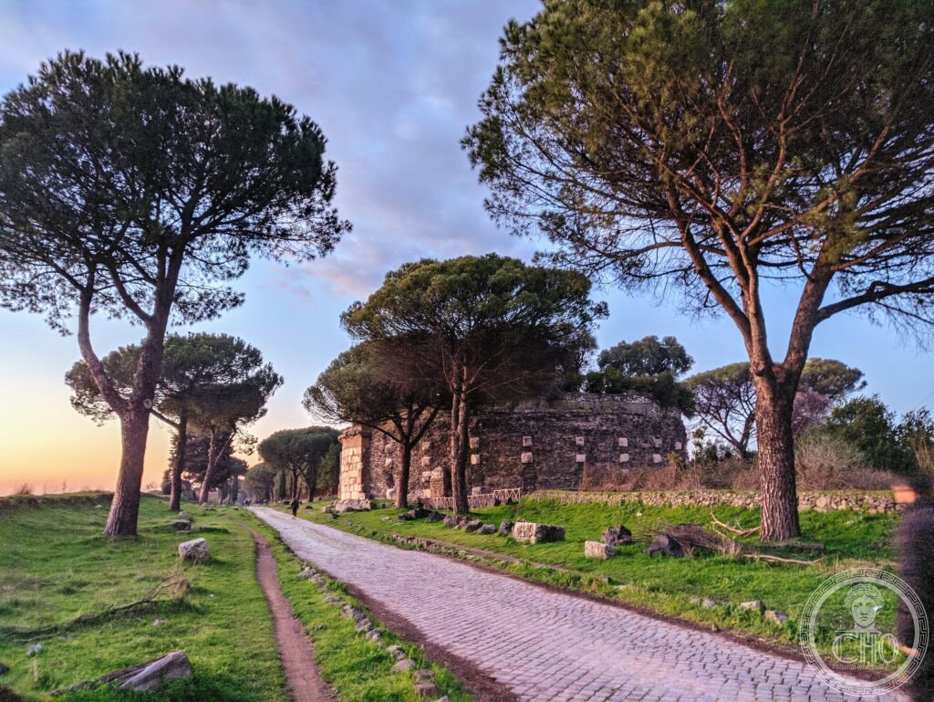
South of Rome, the Appian Way still carries its original basalt paving beneath a colonnade of umbrella pines, past the tomb of Cecilia Metella and the underground galleries of the catacombs. It is the oldest engineered long-distance road to survive largely in place, and the ground on which Roman military ambition met early Christian burial.
At a glance
The Via Appia began in 312 BCE under the censor Appius Claudius Caecus and eventually ran some 540 kilometres from Rome to Brindisi, crossing what are today the regions of Lazio, Campania, Basilicata and Puglia. The stretch just south of Rome, from Porta San Sebastiano past the catacombs of San Callisto and San Sebastiano, preserves original basalt paving set without mortar, along with the Tomb of Cecilia Metella, the Circus of Maxentius and the Villa of the Quintilii.
The road has been put forward for UNESCO World Heritage status as a serial nomination covering the whole route and associated monuments; it has not yet been inscribed.
Key facts
- Founded: 312 BCE, first section Rome to Capua.
- Completed: extended to Tarentum by 268 BCE and to Brindisi by 241 BCE, for a total length of around 540 kilometres.
- Construction: built in layered courses, from a stone foundation up to fitted basalt polygonal paving, engineered to shed water and bear sustained loads.
- Regions crossed: Lazio, Campania, Basilicata and Puglia.
- Protection: managed today as the Regional Park of the Via Appia Antica, established in 1988.
History
The road was begun in 312 BCE by the censor Appius Claudius Caecus, first linking Rome to Capua, then extended in stages south to Tarentum and finally to Brindisi. It became the principal route for Roman military campaigns southward through the Samnite, Pyrrhic and Punic wars, and later served as a key state road maintained by imperial officials after Augustus reorganised the network. In 71 BCE, following the defeat of Spartacus, the Via Appia was used to display crucified rebels along much of its length between Capua and Rome, a punishment left in place for a considerable time as a warning to travellers; the exact duration is not agreed in surviving accounts. Julius Caesar’s body was carried along the road after his assassination in 44 BCE.
From the second century CE, Christian communities began burying their dead in underground catacombs along the road just outside Rome, since burial within the city walls was forbidden. The catacombs of San Callisto and San Sebastiano, developed in this period, became major sites of Christian burial and later of pilgrimage, especially after Christianity was legalised in 313 CE. Underground burial declined from around the sixth and seventh centuries amid disruption from invasions, and the catacombs were later restored under papal patronage, notably by Pope Hadrian I. Through the medieval and early modern periods, the Via Appia continued to serve the Papal States for armies, supplies and pilgrims. Systematic archaeological study began under Pope Pius VI in the late eighteenth century and continued with the nineteenth-century work of the archaeologist Luigi Canina, who catalogued and restored sections of the route. The Regional Park of the Via Appia Antica was established in 1988, and the road has since been proposed, as a serial nomination covering the entire route and its associated monuments, for UNESCO World Heritage status.
What you see
Walking or cycling the first stretch south of Rome, visitors pass long runs of original Roman basalt paving, still bearing the wear of two millennia of traffic, shaded by umbrella pines planted under papal administration in the eighteenth century. The Tomb of Cecilia Metella, a cylindrical travertine mausoleum built for the wife of a Roman general, remains the largest funerary monument on this section of the road, its frieze of garlands and ox skulls still legible.
Further along stand the Circus of Maxentius, once the largest circus built outside Rome itself, and the extensive remains of the Villa of the Quintilii, now open as a museum estate. The catacombs of San Callisto and the adjoining, smaller catacombs of San Sebastiano can be visited on guided tours through their underground galleries, the latter with a fourth-century basilica built above the burial complex. Original Roman milestones, cylindrical markers recording distances and the emperors responsible for the road’s upkeep, still stand in their original positions further along the route.
Practical information
- Access: reachable by public bus from central Rome or by bicycle, which is generally considered the best way to cover the early kilometres of the route; bikes can be hired near the park information centre.
- Car-free days: the road is closed to cars on Sundays along its early stretch, making it busier with cyclists and walkers at that time.
- Visitor centre: the Regional Park’s visitors centre, on Via Appia Antica, provides maps and background on the route; current entry arrangements and opening times should be checked with the park directly.
- Guided visits: the catacombs of San Callisto and San Sebastiano can only be seen with a guided tour.
Getting there
From central Rome, the site is reached by bus from Circo Massimo or San Giovanni, or by bicycle for those wanting to cover the early kilometres of the ancient road itself. Drivers can park near the park visitors centre on Via Appia Antica, bearing in mind that the road is closed to cars on Sunday mornings along its first stretch. Current routes, timetables and any charges are best confirmed through the Regional Park’s own information channels.
Nearby
- Catacombs of San Callisto — within the first couple of kilometres of the route, the largest of the Christian underground burial complexes here.
- Catacombs of San Sebastiano — adjoining San Callisto, with a fourth-century basilica above.
- Tomb of Cecilia Metella — a short distance further along, the standout funerary monument of this stretch.
- Circus of Maxentius and Villa of the Quintilii — a little further south, the largest circus built outside Rome and an extensive villa estate now open to visitors.
- Arch of Trajan, Benevento — much further along the route, considered a particularly well-preserved Roman triumphal arch with a full relief programme.
Sources
- UNESCO
- Regional Park Via Appia Antica
Gallery
Find it on the map
See this place and what’s around it →
📷 Become a Cultural Heritage Online photographer
Share your photos of places: they stay published under your name as the author. The more they're seen, the more you get noticed — and soon a contest will reward the most appreciated photos.
Log in or sign up free to add a photo