Timgad
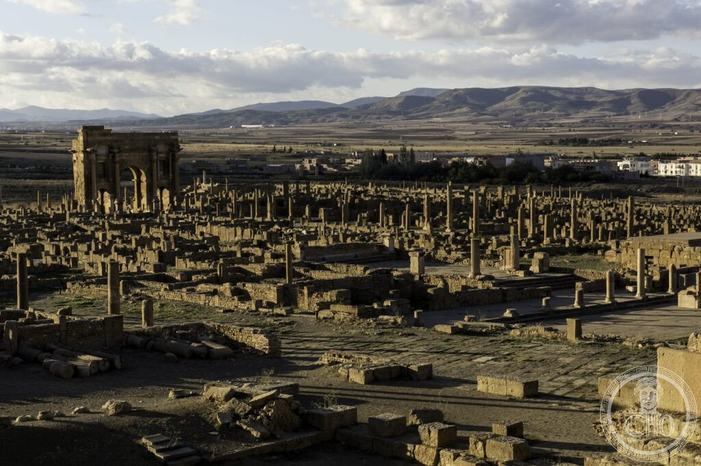
The most perfectly preserved Roman colonial city in the world and the “Pompeii of North Africa” — Colonia Marciana Ulpia Traiana Thamugadi was founded in 100 AD by Emperor Trajan as a veterans’ settlement for soldiers of the Legio III Augusta; planned as a precise 355 x 344 metre grid of 100 equal city blocks (insulae) divided by the cardo maximus and decumanus maximus, it preserves the triumphal arch of Trajan (165 AD), a theatre, a forum, two sets of baths, and a Roman library — one of only three surviving ancient library buildings in the world — in the dry plateau of the Aurès mountains of eastern Algeria, 500 km east of Algiers.
At a glance
Timgad (population of the modern village adjacent to the ruins: approximately 15,000; the ancient city had approximately 15,000 inhabitants at its 3rd-century AD peak) is in Batna Province of eastern Algeria, in the northern slopes of the Aurès mountains, at an altitude of approximately 1,100 metres (a high plateau with cold winters and hot, dry summers). The site is 33 km east of Batna (the provincial capital), 500 km east of Algiers, and 700 km west of Tunis. UNESCO inscribed Timgad in 1982. The remote location (the site receives relatively few foreign tourists compared to its exceptional quality) is one reason the preservation is so excellent: the dry mountain climate, the site’s burial under windblown sand until excavation began in 1880, and the absence of urban encroachment have preserved the original Roman plan at ground level more completely than any other Roman colonial city anywhere in the empire.
Key facts
- The Roman plan (100 AD): the most legible surviving example of Roman colonial town planning in the world — when the Legio III Augusta’s surveyors (the agrimensor or gromaticus, the Roman land surveyor) laid out the cardo maximus (north-south) and decumanus maximus (east-west) at Timgad, they were following a Roman military and colonial planning tradition that went back to the earliest Latin colonies of the 3rd century BC; the original town was a precise square (355 x 344 metres), divided by two main streets and subdivided into a grid of 100 insulae (city blocks) each approximately 20 x 24 metres; a new Roman veteran arriving from Hispania, Gaul, or Italy in 100 AD would have found every street familiar: the forum in the centre, the temples on the forum’s north side, the theatre at the southern edge, the baths at the corners, and the colonnaded main streets leading to the city gates; the later extramural extension of the city (the 2nd–3rd century AD sprawl beyond the original planned walls) grew organically and is immediately distinguishable from the grid by its irregular street pattern
- Arch of Trajan (165 AD): the most photographed monument at Timgad and one of the finest surviving Roman triumphal arches in the world — built in 165 AD under Emperor Marcus Aurelius as the western gate of the decumanus maximus (the main east-west street), the arch is a single-barrel arch of Numidian limestone (the yellow-golden local stone that gives Timgad its warm colour), 12 metres tall and 11 metres wide, with a small flanking pedestrian arch on each side; the dedication inscription records the arch was built with funds from a local patron named Quintus Marcius Turbo; the arch is remarkably intact (the central barrel vault has not required reconstruction) and is the defining landmark of the Timgad site when seen from the western approach; behind the arch, the decumanus maximus runs east for 350 metres to the forum
- Capitoline Temple and Forum: the religious and civic heart of the Roman colony — the forum of Timgad (a large rectangular piazza surrounded by colonnades on three sides, with the basilica [law court and assembly hall] to the south and the curia [city council chamber] to the east) was the centre of public life; the Capitoline Temple (dedicated to the Capitoline Triad of Jupiter Optimus Maximus, Juno Regina, and Minerva — the gods of Rome’s civic religion) occupied a raised podium on the north side of the forum; although the Capitoline Temple is largely ruined, the forum colonnade (partially restored) and the basilica (with one standing column and several bases) give a clear sense of the civic scale of the city; numerous inscriptions from the forum area record the names and careers of Timgad’s magistrates, donors, and soldiers
- Roman Library (late 2nd century AD): one of only three surviving ancient library buildings in the world — the library of Timgad (identified by the niches for book rolls and the configuration of the reading room) is the most complete surviving example of a Roman public library building outside Rome itself; the building consists of a semicircular apsed reading room with a continuous series of rectangular niches in the walls (each niche held a wooden cupboard for scroll rolls, the armarium librorum) and a raised threshold step to protect the books from floor moisture; the library’s presence in Timgad (a military colony far from the major cities of Roman Africa) documents the remarkable reach of Roman literary culture; two other surviving ancient library buildings exist: the Library of Celsus at Ephesus (the only surviving ancient library façade, 135 AD) and the Library of Hadrian in Athens (built 132 AD, only the precinct wall survives)
- Theatre (c. 100 AD): the Roman theatre of Timgad was built at the same time as the founding of the city and is one of the earliest theatres of Roman North Africa — cut into the slope of a hill at the southern edge of the original planned town (as recommended by Vitruvius for theatres, to exploit the natural hillside for the cavea), the theatre seats approximately 3,500 spectators; the scaenae frons (stage building) is partially reconstructed and the theatre is still used for summer performances; the Byzantine fortification builders (c. 535 AD, under Justinian) used the theatre as a quarry for the stones of their fort (built on the north side of the site), and significant portions of the seating and stage were removed in antiquity
- Heritage: UNESCO World Heritage Site, Timgad, inscribed 1982
- GPS: 35.4882° N, 6.4679° E
History
Timgad was founded on 1 August 100 AD (the founding date is recorded on the city’s charter) by the Emperor Marcus Ulpius Traianus (Trajan) as a retirement settlement for veterans of the Legio III Augusta (the Third Augustan Legion, the only legion permanently stationed in Africa, based at Lambaesis, 12 km west of Timgad); the city’s full Latin name, Colonia Marciana Ulpia Traiana Thamugadi, records the dedication to Trajan’s sister Marciana (who died in 112 AD, shortly after the founding); the city grew rapidly and expanded well beyond its original planned area in the 2nd and 3rd centuries AD, adding the large baths (the Great Baths, on the north-western edge of the original town), the library, the Capitoline Temple, and several other public buildings; the population reached approximately 15,000 at its peak; the city was sacked by Berber tribes in the late 3rd century, partially rebuilt, sacked again by the Vandals under Genseric in 430 AD, partially reconstructed under the Byzantine Reconquest (Justinian’s general Solomon built the fort in the north of the city c. 535 AD using the theatre stones), and finally abandoned c. 700 AD as the Arab conquest of North Africa transformed the political and demographic landscape of the Maghreb; windblown sand covered the site until it was rediscovered and excavated by French archaeologists under Émile Masqueray from 1880 (the sand preservation explains the extraordinary completeness of the remains).
What you see
The site is entered from the west (the main entrance road passes under the Arch of Trajan — the single most dramatic entrance to any Roman site in North Africa); from the Arch, walk east along the decumanus maximus (the main east-west street, still paved with the original Roman stone slabs, with the cart ruts carved into the pavement surface visible) to the forum (the central square, 200 metres from the Arch), then north to the library and the Great Baths; south from the forum is the theatre; the museum (on the north side of the site, housed in a converted early-20th-century building) displays mosaics from the site’s private houses and the Timgad legal inscriptions. Allow 2–3 hours for the complete site; the museum is small (30 min). The site is remote and exposed: bring water, sun protection, and sensible shoes (the paving slabs are uneven).
Practical information
- Admission: nominal (approximately 200 DZD, under €2); museum included; no advance booking required; the site is generally open 8am–5pm daily (check locally for seasonal variations)
- Getting there: Timgad is best reached by car (strongly recommended; the site is not accessible by public transport with reasonable convenience); Batna Airport (BLJ) receives domestic flights from Algiers (Air Algérie, 1h, several per week); from Batna city centre drive 33 km east on the N3 road to the site (35 min); from Algiers by car: 500 km east on the A1 motorway to Bordj Bou Arréridj then south on the A46 to Batna (5–6h); a taxi from Batna to the site and back (with waiting time) costs approximately 2,500–3,000 DZD (€18–€22); the site is usually combined with Lambaesis (12 km west, the camp of the Legio III Augusta, one of the best-preserved Roman legionary fortresses in North Africa), Djémila (80 km north-west, a similarly well-preserved Roman city, UNESCO WHS 1982), and the Aurès mountain landscapes (the region is dramatic and underdeveloped, with the Chelia peak at 2,328 m)
- Context: visiting Timgad without the Roman history background can feel like seeing a very large pile of old stones in a dry landscape; context from John Peddie’s The Roman War Machine (1994) or from reading the Wikipedia article before arrival makes the 100-AD founding, the Roman military grid, and the exceptional library make sense as a coherent moment of imperial civilisation-building; the site is almost never mentioned in mainstream British or American travel guides despite being among the most remarkable Roman sites in existence
Getting there
Batna Airport (BLJ): 33 km (35 min). By car from Batna (33 km east on N3). From Algiers by car (500 km, 5–6h on A1 motorway). GPS: 35.4882, 6.4679.
Nearby
- Djémila (ancient Cuicul) — 80 km north-west of Timgad (1h 20 min by car); the companion Roman city of the Aurès region and equally important UNESCO site (WHS 1982) — Cuicul was founded under Emperor Nerva (96–98 AD) and grew into a large city (approximately 20,000 inhabitants) on a triangular spur of the Kabyle mountains, with its extraordinary location (the city had to adapt the Roman grid to a narrow mountain spur, creating a non-standard plan that is more visually interesting than Timgad’s perfect grid) giving it a more dramatic setting; the Arch of Caracalla (216 AD, a double-faced arch marking the entrance to the New Town built in the 2nd–3rd century AD), the Temple of the Severan Family (216 AD, the finest surviving example of Severian dynastic temple in the Roman world outside Rome), and the Great Baths (with intact hypocausts) are the key monuments; the museum (in a 1950s building on the site) contains the finest collection of Roman mosaics in Algeria
- Lambèse (ancient Lambaesis) — 12 km west of Timgad (15 min); the headquarters camp of the Legio III Augusta, one of the largest and best-preserved Roman legionary fortresses in the world — the praetorium (headquarters building, with a colonnaded courtyard of exceptional scale) and the Asklepieion (a healing sanctuary dedicated to Asklepios within the military camp, with a complete plan of bathing and incubation rooms) are the highlights; the camp’s basic plan of barrack blocks, granaries, headquarters, and commander’s house (the praetorium) is readable in the ground plan; a 19th-century French military prison (built using the ancient stones) partially overlies the south part of the site
- Aurès Mountains (Chélia, 2328m) — the Aurès mountain range immediately south of Timgad is one of the most spectacular and least-visited mountain landscapes of North Africa — the Gorges of the Oued el Abiod (the gorges of the White River, immediately south of the village of Arris, 60 km south of Timgad) are comparable in scale and drama to any mountain gorge in the Mediterranean; the Berber Chaouia population of the Aurès were the last indigenous people of North Africa to resist Roman occupation (the Legio III Augusta was stationed at Lambaesis specifically to control the Aurès), the last to resist Arab conquest (late 7th century AD; the Berber queen Dihya, known as the Kahina, fought the Arab armies of Hassan ibn al-Numan in the Aurès until her defeat approximately 698 AD), and the epicentre of the Algerian War of Independence (1 November 1954: the first armed attacks of the FLN began in the Aurès mountains)
Sources
- Wikipedia, Timgad; Legio III Augusta; Library of Timgad, accessed June 2026
- UNESCO, Timgad, WHS reference 290, inscribed 1982
- Eugène Albertini, L’Afrique romaine, Gouvernement Général de l’Algérie, 1937
- Yann Le Bohec, La Troisième Légion Auguste, CNRS Éditions, 1989
Find it on the map
See this place and what’s around it →📷 Diventa un fotografo di Cultural Heritage Online
Condividi le tue foto dei luoghi: restano pubblicate con la tua firma come autore. Più vengono viste, più ti fai conoscere — e presto un concorso premierà le foto più apprezzate.
Accedi o registrati gratis per aggiungere una foto