Su Nuraxi di Barumini (1500-400 a.C.): la Torre Nuragica più Complessa della Sardegna — il Nuraghe a Quattro Torri, il Villaggio di 200 Capanne e la Civiltà Sarda che Nessuno Ha Ancora Decifrato (UNESCO 1997)
Su Nuraxi di Barumini — built in stages from approximately 1500 to 400 BCE, rediscovered under a mound of earth by archaeologist Giovanni Lilliu in 1949, and inscribed as the sole representative of the nuragic civilisation in UNESCO's World Heritage list — is the most complex and best-preserved nuraghe in Sardinia: a four-tower bastion surrounding a central tower, enclosed by a village of approximately 200 circular stone huts, all built without mortar from local basalt blocks in a dry-stone construction technique of extraordinary precision.
At a glance
Su Nuraxi di Barumini (province of Medio Campidano / Sud Sardegna, Sardinia; UNESCO 1997, ref. 833) is the best-preserved example of a nuraghe — the type of dry-stone tower construction unique to Sardinia, with approximately 7,000 surviving examples across the island — and the only nuragic site on the UNESCO World Heritage List. The inscription (1997) recognizes the site as an outstanding example of a type of building unique in the history of world architecture: the corbelled stone tower (a structure built by overlapping horizontal courses of stone with each course projecting slightly further inward than the one below, creating a false vault without keystone) used in the context of a complex multi-tower military and communal architecture without any equivalent in contemporary Mediterranean building practice. The nuragic civilisation (c. 1800-500 BCE) built and used the nuraghi but left no written records and its language, social organization, and religious practices remain largely unknown despite intensive archaeological investigation since the 1950s.
Key facts
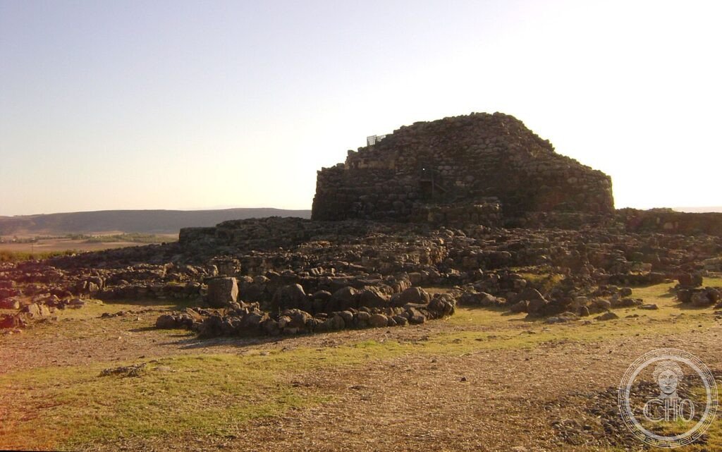
- The central tower (nuraghe-mastio, c. 1500-1300 BCE): The original structure, the oldest element of the complex; built of large basalt blocks in dry-stone corbelling technique; originally approximately 18-20 metres high (the surviving portion after partial collapse is approximately 14 metres); the interior has a single ground-floor chamber with a corbelled roof (false cupola) and a staircase in the wall thickness leading to an upper chamber; the chamber diameter is approximately 6 metres; the walls are 4-5 metres thick at the base
- The bastion (c. 1300-1100 BCE): In the Bronze Age, the central tower was enclosed by a polygonal bastion with four corner towers connected by straight curtain walls; the new structure surrounded the original tower on three sides (leaving the south face open toward the approach), creating a compound with an interior courtyard approximately 20 metres across. This phase transformed the single-tower nuraghe (the simplest and most common type) into a multi-tower complex (the most prestigious and architecturally complex type)
- The village (c. 1100-400 BCE): In the late Bronze Age and early Iron Age, a village of approximately 200 circular stone huts was built against and around the exterior of the bastion; the huts vary in diameter (3-8 metres) and some have surviving secondary rooms and benches; some huts were used for communal functions (identified by hearths, votive deposits, and large storage jars); the village was continuously inhabited until approximately 400 BCE when it was abandoned
- Giovanni Lilliu (1914-2012): The Sardinian archaeologist who excavated Su Nuraxi di Barumini beginning in 1949; Lilliu was the first to identify the systematic pattern of nuragic construction and to propose a chronological framework for nuragic architecture; he is considered the founder of Sardinian archaeology as a discipline. The site had been covered by a natural accumulation of earth and collapse material and was known locally as “Is Paras” (the walls); Lilliu's excavation, conducted over many seasons, revealed the full extent of the complex for the first time
- UNESCO: 1997, ref. 833
- GPS: 39.7034, 9.0047 — Google Maps
History
The nuragic civilisation was active in Sardinia from approximately 1800 to 500 BCE; it left approximately 7,000 nuraghi (varying from simple single-tower structures to complex multi-tower compounds), approximately 70 megalithic tombs known as “giants' tombs” (tombe dei giganti), approximately 30 sacred well sanctuaries, and several thousand smaller structures. Despite this architectural productivity, the nuragic people left no written records and their language, religion, and social organization are known only from archaeological evidence. The relationship of the nuragic civilisation to the Phoenician and Carthaginian colonists who established trading posts on the Sardinian coast beginning in the 9th century BCE is debated: the abandonment of Su Nuraxi around 400 BCE broadly coincides with the expansion of Carthaginian control inland, but whether the abandonment was forced or voluntary is unknown. The Romans conquered Sardinia in 238 BCE and found the nuraghi already abandoned; they used some as rural outposts and quarried others for building material.
What you see
The visit to Su Nuraxi di Barumini (guided tours only, departing every 30-45 minutes from the museum in Barumini; in Italian and English) covers the full circuit of the visible remains. The approach road from Barumini (1.5 km) gives a first view of the main tower rising above the surrounding plain. The tour begins at the village perimeter: the circular hut foundations are densely packed against the bastion exterior, with paths threading between them; the pottery fragments and votive materials found in the huts are displayed in the Barumini museum (Palazzo Zapata, 1.5 km away). The bastion gateway (the main entrance to the compound, on the south face) passes under a corbelled lintel into the interior courtyard: the well (a circular shaft reaching the water table) is in the centre. The central tower staircase (accessible for a portion of its height; the upper chamber is closed to visitors for conservation reasons) gives a close view of the corbelling technique.
The panoramic view from the top of the central tower over the Campidano plain (the broad agricultural valley between the two mountain chains of Sardinia) and the surrounding landscape is the most immediately striking spatial experience: the nuraghe is visible from many kilometres away in all directions, confirming its function as a territorial marker as much as a defensive structure.
Gallery
Practical information
- Su Nuraxi di Barumini: Via Funtana 1, Barumini (VS); guided tours only (no independent visits to the site); tours depart every 30-45 minutes from the museum in Barumini (Palazzo Zapata); open daily 9:00-18:00 (summer) and 9:00-17:00 (winter); admission ~€12 (site+museum combined); duration ~1h30 per tour.
- Museo della Fondazione Barumini Sistema Cultura (Palazzo Zapata): In Barumini town centre, 1.5 km from the nuraghe; open same hours; contains finds from the excavation (pottery, bronzetti figurines, votive objects) and explanatory panels on nuragic civilisation.
- Season: Year-round; summer (July-August) tours can be crowded; spring and autumn are quieter. The Campidano plain is very hot in July-August (36-40°C); the nuraghe site has no shade.
Getting there
Via Funtana 1, Barumini (VS), Sardegna. GPS 39.7034, 9.0047. By car: from Cagliari, SS131 north to Sanluri then SP78 east to Barumini (60 km, 1h); from Oristano, SP53 south-east to Barumini (50 km, 1h); no direct train service to Barumini. By bus: ARST bus from Cagliari (1h30-2h, limited service; check arst.sardegna.it). Note: a car is strongly recommended for visiting Barumini and for combining with other nuragic sites in the area.
Nearby
- Villanovaforru Nuraghe Genna Maria — 15 km north-west; a simpler nuraghe (single tower + secondary bastion) with a good local museum (Museo Civico Genna Maria, Villanovaforru) displaying fine nuragic bronzetti figurines
- Isili e Nuraghe Is Paras — 20 km north-east; another well-preserved nuraghe with accessible interior corbelled chambers
- Cagliari — 60 km south; the capital of Sardinia; the Museo Nazionale Archeologico di Cagliari (Piazza Arsenale, in the Castello quarter) has the most complete nuragic bronzetti collection in the world (over 500 figurines), including the “Cagliari bronzetti” (warrior, boxer, archer, and mother-goddess figures from nuragic sacred well sanctuaries)
Sources
- UNESCO: whc.unesco.org/en/list/833
- Wikipedia EN: Su Nuraxi di Barumini
- Lilliu, Giovanni: La civiltà dei Sardi, ERI, 1963
- Fondazione Barumini Sistema Cultura: fondazionebarumini.it
Find it on the map
See this place and what’s around it →📷 Diventa un fotografo di Cultural Heritage Online
Condividi le tue foto dei luoghi: restano pubblicate con la tua firma come autore. Più vengono viste, più ti fai conoscere — e presto un concorso premierà le foto più apprezzate.
Accedi o registrati gratis per aggiungere una foto