
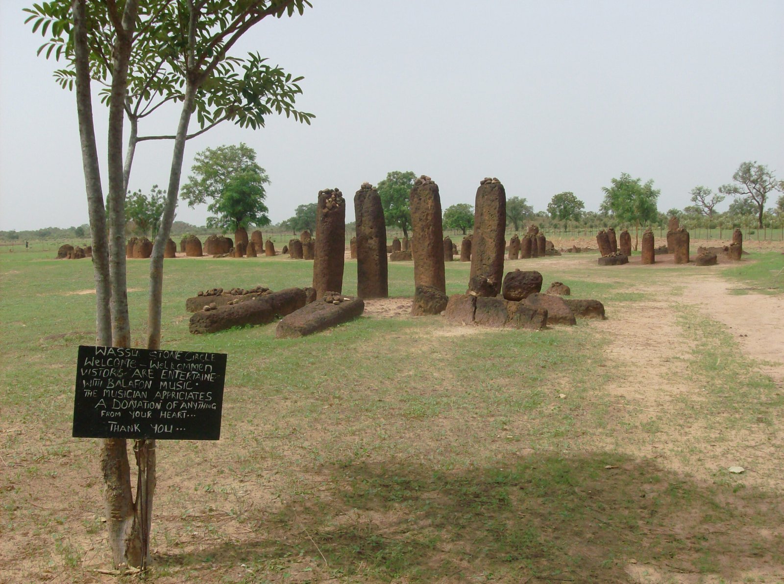
Stretching across a 350-kilometre band of West African savannah, the Senegambia stone circles are the largest concentration of funerary megalithic monuments in the world — more stone circles than in all the British Isles combined, built over nearly two millennia by the ancestors of the Serer and Manding peoples.
At a glance
Between the Salum River to the north and the Gambia River to the south, approximately 1,000 individual stone circles are grouped into some 93 sites across Senegal and the Gambia, covering a territory of roughly 30,000 square kilometres. Each circle was built from laterite — the iron-rich tropical hardrock forming distinctive rusty-red monoliths, typically 1 to 2.5 metres tall — arranged in rings of 8 to 14 stones around one or more burials. UNESCO inscribed four representative sites in 2006: Sine Ngayène and Wanar in Senegal, and Wassu and Kerbatch in the Gambia.
Key facts
- UNESCO inscription: 2006 (Stone Circles of Senegambia)
- Period: c. 300 BC – AD 1600 (approx. 1,900 years of continuous tradition)
- Scale: ~1,000 circles at ~93 sites; total estimated 10,000+ including smaller examples
- Material: Laterite (iron-rich tropical hardrock), quarried and shaped locally
- Stone height: 1–2.5 m; circles of 8–14 stones per monument
- Countries: Senegal (Sine Ngayène, Wanar) and the Gambia (Wassu, Kerbatch)
- Custodian peoples: Descendants of Serer and Manding-speaking communities
History
The Senegambia stone circle tradition began around 300 BC and persisted until approximately AD 1600 — a span of nearly two millennia during which generations of communities in this savannah corridor quarried and erected laterite monoliths as funerary monuments. The builders were the ancestors of the Serer people and other Manding-speaking groups whose territories these circles marked. Archaeological excavations have revealed that each circle covers one or more burials, sometimes containing the remains of up to 20 individuals accompanied by iron weapons, tools, ceramics, and personal ornaments. This burial pattern — multiple individuals sharing a single monument — indicates the circles commemorated people of social prominence: warriors, chiefs, or religious figures whose deaths warranted monumental markers visible across the flat savannah.
The longevity of the tradition is one of the most striking aspects of the Senegambia phenomenon. While megalithic traditions in Europe flourished and then ended thousands of years ago, communities in this narrow band between two rivers maintained the same architectural and ritual vocabulary — circular arrangement of laterite pillars around a burial — for longer than the entire span of recorded Roman history. The circles represent not an ancient wonder frozen in time but evidence of a living cultural institution, repeated across dozens of generations.
Systematic archaeological investigation began in the mid-20th century. Excavations at Wassu, Sine Ngayène, and Wanar have produced radiocarbon dates confirming the broad 300 BC to AD 1600 timeframe. The four UNESCO sites were selected as representative of the full geographic and typological range of the complex, though the total number of circles across the region is estimated at well over 10,000 when smaller or less well-preserved examples are included.
What you see
The circles consist of upright laterite pillars — locally quarried, roughly cylindrical or rectangular in section, weathered to a dark reddish-brown by centuries of tropical humidity and seasonal rain. Standing 1 to 2.5 metres above the surface, they are arranged in rings typically 4 to 6 metres in diameter, occasionally with a larger central stone marking the principal burial. Many circles retain a complete ring; others have partially collapsed over the centuries. The savannah grass grows around and between the pillars, and the circles often sit on slightly elevated ground, visible from a distance across the flat West African landscape.
The Wassu site in the Gambia is the most visited of the four UNESCO sites, with a small museum adjacent to the circles. Sine Ngayène in Senegal contains the largest concentration within the inscribed area. At Kerbatch and Wanar, the circles sit in more isolated settings among farmland and bush, giving a direct sense of how the monuments originally appeared — markers of the dead placed conspicuously in the territories of the living.
Practical information
- Access: Wassu (Gambia) reachable from Banjul via a 2–3 hour drive east along the North Bank Road; Sine Ngayène (Senegal) reached from Kaolack
- Facilities: Wassu has a visitor centre and small museum; other sites have minimal facilities
- Best season: November to March (dry season); rainy season roads (June–October) can make remote sites inaccessible
- Admission: Small entrance fee at Wassu; check locally for current rates
- Guides: Local guides available at Wassu; recommended for more remote sites
Getting there
The most practical base for visiting the Gambian sites (Wassu, Kerbatch) is Banjul or the Atlantic coast resort area, from which Wassu is approximately 165 km east along the North Bank Road — a drive of 2 to 3 hours. For the Senegalese sites (Sine Ngayène, Wanar), Kaolack is the nearest major city. International flights serve Banjul International Airport and Dakar Léopold Sédar Senghor International Airport; the sites can also be included in overland journeys combining Senegal and the Gambia.
Nearby
- James Island and Related Sites — UNESCO-inscribed island fortress on the Gambia River, key site in Atlantic slave trade history (approx. 80 km west of Wassu)
- Abuko Nature Reserve — the Gambia oldest wildlife sanctuary, near Banjul
- Kaolack — major Senegalese transport hub serving Sine Ngayène and Wanar, known for its great mosque and traditional market
- Basse Santa Su — Gambian town on the upper river, gateway to eastern Gambia near Kerbatch
Sources
- UNESCO World Heritage List — Stone Circles of Senegambia (2006): whc.unesco.org/en/list/1226
- Wikipedia — Stone Circles of Senegambia: en.wikipedia.org
- Gambia Tourism Board — site information and visitor guidance
- Direction du Patrimoine Culturel, Senegal — conservation and documentation records
- McIntosh, S.K. and McIntosh, R.J. — West African megalithic tradition context (1980)
Find it on the map
See this place and what’s around it →📷 Become a Cultural Heritage Online photographer
Share your photos of places: they stay published under your name as the author. The more they're seen, the more you get noticed — and soon a contest will reward the most appreciated photos.
Log in or sign up free to add a photo