

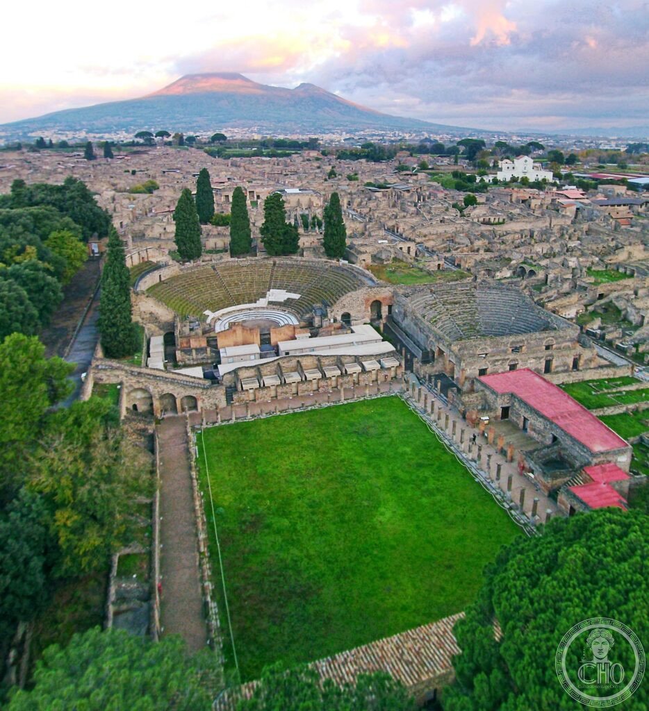
The most important Roman archaeological site in the world and the most vivid surviving portrait of daily life in the ancient world. Pompeii, buried under volcanic ash by the eruption of Mount Vesuvius on 24 August 79 AD, was frozen in a single moment of time. The wheel ruts in the streets, the bread still in the bakery ovens, the electoral slogans on the walls, and the 1,044 plaster casts of its inhabitants in their final postures have made it the most visited archaeological site in Europe.
At a glance
Pompeii (the ancient city; Pompei Scavi; the modern municipality is written “Pompei” without the second ‘i’) lies 23 km south-east of Naples, at the foot of Mount Vesuvius. The archaeological park covers approximately 44 hectares of the approximately 66 hectares of the ancient city (the remaining 22 hectares remain unexcavated beneath the modern town of Pompei and its surroundings). Excavations have been ongoing since 1748, when the Bourbon King Charles III ordered the first systematic exploration. The pace of excavation has slowed deliberately in recent decades. The priority is now conservation of existing structures rather than new excavation. The Great Pompeii Project (a major European Union-funded conservation programme, 2012–2025+) has stabilised many buildings that were at risk of collapse and has continued exploration in the Regio V area (the north-east quarter, previously unexcavated), producing spectacular finds including the intact thermopolium (a Roman fast food bar with painted menu and food residues in the serving containers), the room of the slaves, and the room with erotic paintings that may indicate a high-status brothel. Approximately 3 million visitors per year, making Pompeii the most visited archaeological site in Italy.
Key facts
- The Fiorelli body casts: the most haunting and the most important archaeological technique in Pompeii. When the bodies of Pompeii’s residents decomposed inside the volcanic ash over the centuries, the cavity left by the organic material preserved the exact shape of the body. The archaeologist Giuseppe Fiorelli recognised in 1863 that by injecting plaster of Paris into these cavities, he could recover the exact three-dimensional form of the body at the moment of death. 1,044 casts have been made to date. Each one shows the individual’s posture, facial expression, clothing, and sometimes hair in the final moment. Some show obvious signs of attempted shelter (a family group huddled together, the parents covering the children). Some show signs of panic (a person who ran but did not make it). The Museum of the Victims in the Antiquarium of Pompeii displays many casts. Others are displayed in situ in the spots where they were found. The casts are the most emotionally powerful objects in all of Roman archaeology.
- The daily life of ancient Rome: no other site provides such complete evidence for how ordinary people lived 2,000 years ago. Pompeii preserves: the street network with stepping stones (large stones placed across the street at intervals, the same height as the road kerb, allowing pedestrians to cross without stepping in mud or sewage; the gaps between the stones are exactly wide enough for a cart wheel — Pompeii’s ancient traffic engineering). The wheel ruts worn into the stepping stones (showing which streets had heavy cart traffic). The electoral graffiti on the walls (approximately 2,800 electoral notices painted on the exterior walls of buildings, endorsing candidates for the two annual magistrate elections — the most complete surviving political campaign record from the ancient world). The graffiti (approximately 11,000 pieces of informal writing — insults, poetry, declarations of love, mathematical calculations, gladiator schedules — the most extensive corpus of casual written Latin from any single site). The thermopolia (the fast-food bars; 80 identified in Pompeii; counters with circular holes for containers of warm food; the recently excavated Regio V thermopolium had carbonised food residues in the containers — fragments of pork, lamb, fish, snails, and a wine-based sauce).
- The ampitheatre: the oldest surviving stone amphitheatre in the Roman world. The Amphitheatre of Pompeii (built c. 70 BC; seating for approximately 20,000 spectators — larger than the entire population of the city; used for gladiatorial contests and animal hunts; the site of a notorious brawl in 59 AD between Pompeii fans and visitors from the neighbouring town of Nuceria that was so violent it was reported to the Roman Senate and resulted in a 10-year ban on amphitheatre games; painted in the stadium’s interior showing the brawl has been found; the Pink Floyd “Live at Pompeii” concert film was filmed here in 1971, with no audience, using the empty amphitheatre as a setting).
- Heritage: UNESCO World Heritage Site (Archaeological Areas of Pompei, Herculaneum, and Torre Annunziata), inscribed 1997.
- GPS: 40.7506° N, 14.4897° E.
History
Pompeii was founded c. 7th–6th century BC by the Oscans. Occupied by the Samnites (5th century BC), Lucanians (425–290 BC), and incorporated into the Roman Republic (after the Social War, 90–89 BC). A Roman colony named Colonia Cornelia Veneria Pompeianorum was established after a Sulla siege in 89 BC. The city was flourishing as a prosperous commercial centre when Vesuvius erupted on 24 August 79 AD (the date given by Pliny the Younger, the only eyewitness whose account survives; the city was also affected by a major earthquake in 62 AD, still being repaired in 79 AD). The site was rediscovered in the 16th century but systematic excavation began in 1748 under the Bourbon kings of Naples. Fiorelli developed the plaster cast method in 1863. UNESCO WHS 1997. The Great Pompeii Project began in 2012 and is the largest archaeological conservation project in Italy.
What you see
The route through Pompeii (a minimum of 3–4 hours for the highlights; a full day for comprehensive coverage): the Forum (the civic and religious centre; the Temple of Jupiter with Vesuvius behind it; the Basilica, the largest building in Pompeii; the Municipal Buildings; the Macellum or covered food market). The Villa of the Mysteries (outside the main city gate, 15 min walk west; the largest and best-preserved room of continuous wall painting from the ancient world — 29 nearly life-size figures in a continuous painted frieze on a deep Pompeian red background, depicting an initiation ceremony into the Dionysiac mysteries; the exact meaning remains debated; one of the most important and most beautiful paintings from antiquity). The House of the Faun (the largest private house in Pompeii; famous for the bronze dancing faun in the central atrium and for the Alexander Mosaic, a 6-metre floor mosaic showing the Battle of Issus between Alexander the Great and Darius of Persia; the original mosaic is in the Naples Archaeological Museum, a replica is in situ). The body cast gallery in the Antiquarium. The Amphitheatre and the Large Palaestra (the gladiatorial training ground).
Practical information
- Admission and hours: approximately EUR 16 (entrance fee 2026; subject to seasonal pricing; timed entry tickets required July–September; available at pompeiisites.org). Open daily 9am–7pm (last entry 5:30pm; April–October). 9am–5pm (last entry 3:30pm; November–March). The site is very large (44 hectares; comfortable walking shoes essential; the ancient stone pavements are uneven). In summer (July–August), the site is extremely hot (40°C+ in the exposed streets; no shade; bring at least 2 litres of water per person; the best strategy is to arrive at opening and leave by noon, then return in late afternoon when the crowds thin). A combined ticket with Herculaneum, Oplontis, Stabiae, and Boscoreale is available and is excellent value.
- Getting there: the Circumvesuviana railway (a narrow-gauge suburban railway; departs from Naples Porta Nolana and Naples Centrale stations; the Pompeii Scavi – Villa dei Misteri station is immediately adjacent to the main Porta Marina entrance; approximately 40 min from Naples Centrale; approximately EUR 3.20 single; runs every 30–40 min). From Rome: 2h 30 min by Frecciarossa train to Naples, then 40 min by Circumvesuviana. Alternatively, hire a guide in Naples and travel by private transfer.
- Herculaneum: strongly recommended as a companion to Pompeii. Herculaneum (Ercolano; 15 km west of Pompeii; 20 min on the Circumvesuviana; the Ercolano Scavi station; the same combined ticket covers both sites) is smaller than Pompeii but better preserved: the superheated pyroclastic flow that buried Herculaneum (rather than the ash and pumice that buried Pompeii) carbonised organic materials. Wooden furniture, food, papyrus scrolls, and boats. That ash would have destroyed. Herculaneum has the best-preserved wooden materials from any Roman site, including the only surviving Roman boat. The site is less crowded than Pompeii. The underground archaeological tour (the Herculaneum Tunnels; the 18th-century Bourbon excavation tunnels) is the most unusual archaeological tour in Italy.
Getting there
Circumvesuviana train from Naples (40 min, EUR 3.20). From Rome: Frecciarossa to Naples (2h 30 min) then Circumvesuviana. GPS: 40.7506, 14.4897.
Nearby
- Mount Vesuvius. 10 km north of Pompeii (30 min by road from Pompeii; shuttle buses to the crater rim depart from Ercolano on the Circumvesuviana). The volcano responsible for the destruction of Pompeii and the most famous volcano in Europe. Mount Vesuvius rises to 1,281 m and is the only active volcano on the European mainland. Its last eruption was in 1944, and the present quiet has lasted unusually long, which concerns volcanologists: approximately 3 million people live inside the “red zone” directly exposed to pyroclastic flows in a future eruption, the highest-risk volcanic population in the world. The crater rim is reached by a paved path, 2.5 km from the car park and 30 min on foot, with an entrance fee of approximately EUR 10. The crater is approximately 500 m wide and 200 m deep, fumaroles are visible inside it, and the view from the rim takes in Naples, the bay, Capri and, on clear days, the Apennines.
- Naples Archaeological Museum (MANN). 30 min from Pompeii by Circumvesuviana then metro, to Naples Museo station. It is the most important museum in Italy for Roman artefacts. The Alexander Mosaic, the floor mosaic from the House of the Faun at Pompeii showing the Battle of Issus, is the most important ancient mosaic in the world: 5.13 × 2.71 m, composed of approximately 1.5 million tesserae. The Farnese Collection of ancient sculpture holds the Farnese Hercules and the Farnese Bull, the largest ancient marble statue group in existence. And the Secret Cabinet, Il Gabinetto Segreto, gathers the erotic art of Pompeii and Herculaneum — phallus-shaped wind chimes, sexual depictions from brothels and private homes, erotic mosaics — kept in a locked room and open to adults only since 2000.
- Paestum. 100 km south of Pompeii (1h 30 min by road; or 1h 30 min by train from Naples to Paestum station). The best-preserved Greek temples in the world outside Greece. Paestum (the ancient Greek colony of Poseidonia, founded c. 600 BC; three Doric temples survive in almost complete condition — the Temple of Hera I (the Basilica; c. 550 BC; the oldest; the exterior columns are still standing with the original entablature), the Temple of Hera II (the Tempio di Nettuno; c. 450 BC; the most complete; 36 Doric columns still standing to full height; no roof, but everything below the roof line survives), and the Temple of Athena (c. 500 BC)). The National Museum of Paestum contains the unique Tomb of the Diver (a painted Greek tomb, c. 480 BC; the only complete Greek figural painting from the 5th century BC surviving anywhere; the lid painting shows a naked young man diving into a body of blue water — possibly a metaphor for death; the four wall paintings show a banquet scene of extraordinary freshness and informality).
Sources
- Wikipedia, Pompeii. Plaster casts of Pompeii. Amphitheatre of Pompeii, accessed June 2026.
- UNESCO, Archaeological Areas of Pompei, Herculaneum and Torre Annunziata, WHS reference 829, inscribed 1997.
- Mary Beard, Pompeii: The Life of a Roman Town, Profile Books, 2008.
Find it on the map
See this place and what’s around it →Historical events at this place (1)
📷 Become a Cultural Heritage Online photographer
Share your photos of places: they stay published under your name as the author. The more they're seen, the more you get noticed — and soon a contest will reward the most appreciated photos.
Log in or sign up free to add a photoIs this page about you?
This page is read by travellers and heritage enthusiasts who find it on Google. Tell us how you are connected to this place and we will take it from there.