
The largest marine protected area on Earth is also a sacred Native Hawaiian landscape and the site of the Pacific War’s turning point. Almost none of it can be visited, yet its scale, its untouched reefs and its layered history make it one of the most significant places in the Pacific.
At a glance
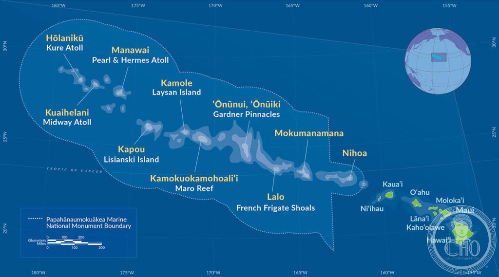
Papahānaumokuākea stretches across roughly 2,000 kilometres of open ocean northwest of the main Hawaiian Islands, encompassing ten islands and atolls and their surrounding reefs. The area is larger than the combined total of all United States national parks, and its coral reef systems are among the least disturbed in the Pacific, since every island bar research stations and the Midway wildlife refuge remains uninhabited.
Around 7,000 marine species have been recorded within its waters, roughly a quarter of them found nowhere else. The monument is a stronghold for the Hawaiian monk seal, one of the world’s most endangered marine mammals, for the green sea turtle, and for the Laysan albatross, most of whose world population nests here.
Key facts
- Extent: around 362,061 square kilometres, spanning roughly 2,000 km of the central Pacific.
- Species richness: around 7,000 marine species recorded, with roughly a quarter endemic to the region.
- Key wildlife: Hawaiian monk seal, green sea turtle, Laysan and black-footed albatross, and thirteen other seabird species.
- Designation: inscribed as a UNESCO World Heritage Site in 2010, the first US site listed for both natural and cultural criteria.
- Historical layer: site of the Battle of Midway, fought in June 1942, one of the decisive naval engagements of the Second World War.
History
Archaeological remains on Nihoa and Mokumanamana, including stone structures, agricultural terraces and religious platforms, show that ancient Hawaiians settled parts of the Northwestern Hawaiian Islands as early as the first millennium CE. Voyagers from the Marshall Islands and elsewhere in the Pacific are also thought to have visited the chain.
Western contact began in 1826, when the American ship Courier wrecked on Midway. Guano mining companies began working the islands from the mid-nineteenth century, and the United States annexed the Northwestern Hawaiian Islands as part of its wider annexation of Hawaii around the turn of the twentieth century. Midway Naval Air Station, established in 1941, became a key American forward base, and in June 1942 the waters around the atoll saw the Battle of Midway, in which US forces sank four Japanese fleet carriers and effectively ended Japan’s offensive capacity in the Pacific.
What you see
In Native Hawaiian cosmology, Papahānaumokuākea takes its name from the union of Papahānaumoku, the Earth Mother, and Wākea, the Sky Father, whose joining is said to have given rise to the Hawaiian islands and people. The Northwestern Hawaiian Islands are regarded as the ancestral homeland, and the surrounding waters are known as the pathway by which souls return to that homeland after death. Native Hawaiians took an active part in the process that led to the site’s UNESCO listing.
Physically, almost the entire monument is closed to casual visitors. The one exception is Midway Atoll National Wildlife Refuge, where the remnants of the 1942 naval air station stand alongside a memorial to those who died in the battle, set among nesting colonies of albatross and the beaches used by monk seals and turtles.
Practical information
- Access: a permit from the US Fish and Wildlife Service is required for any visit, and access is limited to Midway Atoll.
- Transport: there is no commercial passenger air service; visits depend on refuge-organised charter flights, occasional berths on research vessels, or permitted yacht passages.
- Programmes: the refuge occasionally runs small group experiences for photographers and researchers; current availability should be checked directly with the US Fish and Wildlife Service.
- For most people: the monument is best experienced through documentary coverage, including the BBC’s Blue Planet II and National Geographic and Werner Herzog productions on the region.
Getting there
There is no commercial route to Midway Atoll or any other part of the monument. Access depends on a US Fish and Wildlife Service permit combined with a charter flight, a research vessel berth or a permitted yacht passage, arranged through the refuge’s official channels. On a clear day the direction of the Northwestern Hawaiian Islands chain can sometimes be traced from the main island of Kauai, though the islands themselves lie far out of sight.
Nearby
- Kauai — about 2,400 km southeast, the northernmost of the main Hawaiian Islands, known for the sea cliffs of the Na Pali Coast and the Waimea Canyon.
- Haleakalā National Park, Maui — about 2,500 km southeast, a dormant shield volcano whose summit caldera offers sunrise views above the clouds and hosts the endemic silversword plant.
Sources
- Wikipedia
- UNESCO
Find it on the map
See this place and what’s around it →📷 Become a Cultural Heritage Online photographer
Share your photos of places: they stay published under your name as the author. The more they're seen, the more you get noticed — and soon a contest will reward the most appreciated photos.
Log in or sign up free to add a photo