Paestum — I templi dorici della Magna Graecia
Paestum (UNESCO 1998, rif. 842) conserva i tre templi dorici greci più grandi e meglio conservati al di fuori della Grecia: fondati dai coloni achei come Posidonia (c.600 BCE), sopravvissuti ai Lucani (400 BCE), a Roma (273 BCE) e alla malaria medievale che spopò la città, riemergendo dalla macchia mediterranea nel Settecento sotto gli occhi degli architetti del Grand Tour.
At a glance
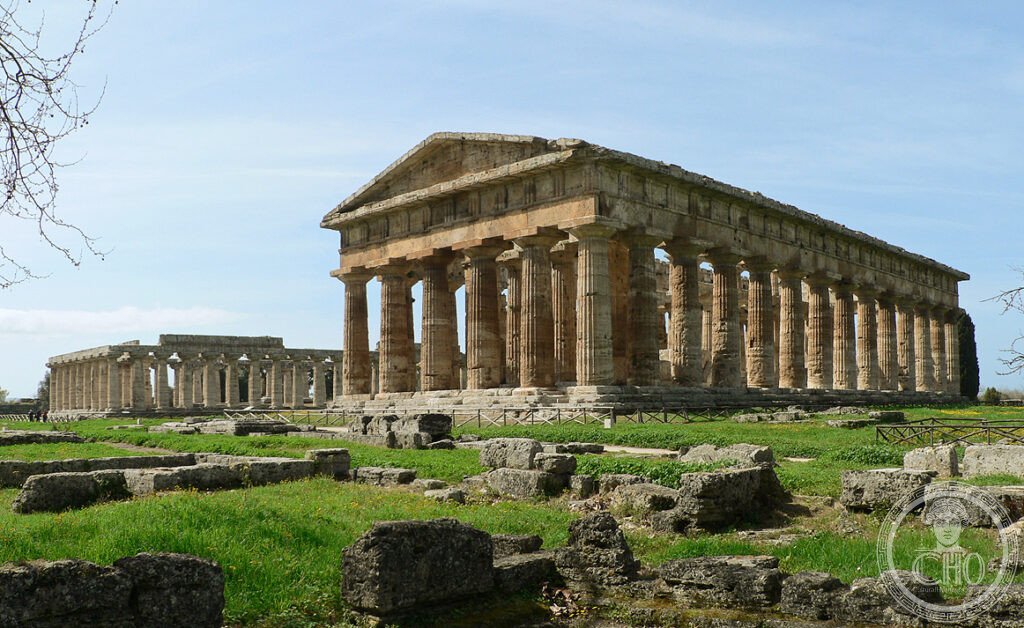
Paestum Campania Italy (40.4222 N 15.0064 E UNESCO WHS 1998 reference 842: the most precisely Paestum zone Cilento Campania Italy: the site (the ancient city of Posidonia/Paestum: founded c.600 BCE by Greek colonists from Sybaris (a colony of Achaea in southern Greece): the city was called “Posidonia” (city of Poseidon) by the Greeks; the Romans renamed it “Paestum” (273 BCE): the location (the Piana del Sele: a flat coastal plain of the Cilento region, 40 km south of Salerno: bounded by the Sele river to the north and the Alento river to the south: the ancient city walls (5 km circumference) still partially visible)): the temples (3 Doric temples in various states of preservation: Tempio di Era I (c.550 BCE, the oldest: 50 m × 24.5 m; 9 × 18 columns; known as “Basilica” in early descriptions because the excavators mistook it for a secular building); Tempio di Poseidone (460-450 BCE: 59.98 m × 24.26 m; 6 × 14 columns: the best preserved; most likely dedicated to Hera, not Poseidon); Tempio di Cerere (c.500 BCE: 32.88 m × 14.54 m; 6 × 13 columns; now considered dedicated to Athena, not Ceres))).
Key facts
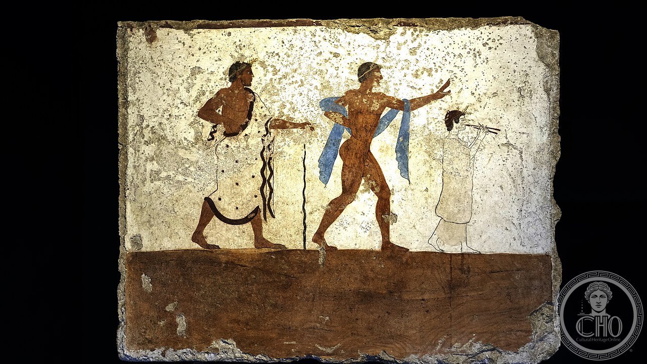
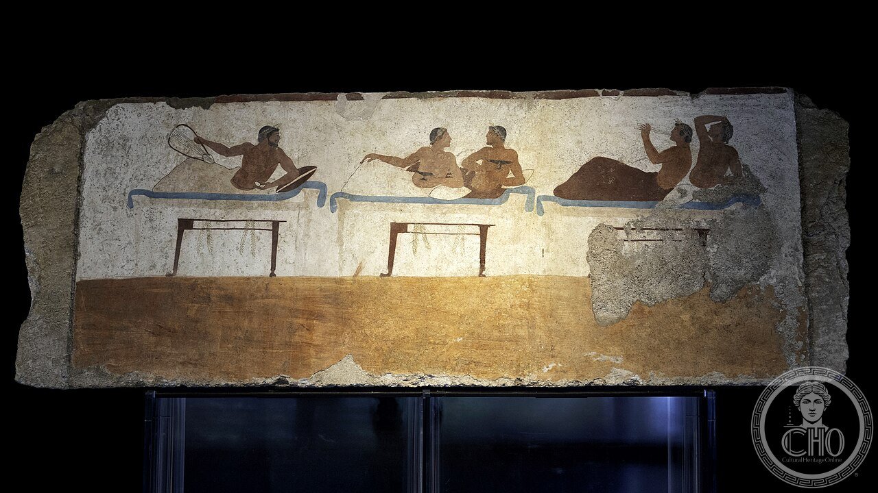
- Tempio di Poseidone (460–450 BCE) e l’architettura dorica di Paestum: the Temple of Poseidon (the best-preserved Greek temple in the world except for the Theseion (Hephaisteion) in Athens (449-415 BCE): the dimensions (59.98 m × 24.26 m: 6 columns across the short sides × 14 columns along the long sides (the peristyle): each column is 8.88 m tall and 2.09 m in diameter at the base (the “entasis”: the slight outward curve of the column shaft that creates the optical illusion of straightness)): the material (travertine limestone from local quarries: the same honey-golden limestone as the Basilica and the Temple of Ceres): the construction (the blocks are fitted without mortar, held in place by their own weight and the precision of the cutting: the largest blocks weigh approximately 8 tonnes): the interior (there are 2 rows of 7 columns inside the cella (the inner chamber) that divide it into a nave and 2 aisles: the original roof was wooden and has not survived); the Tomba del Tuffatore (the “Tomb of the Diver”, 480-470 BCE: discovered 1968 CE: 5 limestone slabs painted with frescoes (the “symposion” on 4 slabs + the famous “diver” on the lid slab: the only known example of Greek figure painting on tomb walls outside Greece: the diver (a young man diving from a stone diving board into a body of water: the only surviving complete example of ancient Greek painting on a flat surface outside of Egypt): now in the Museo Nazionale di Paestum)
- GPS: 40.4222° N, 15.0064° E (Via Magna Graecia, Capaccio Paestum, Campania)
History
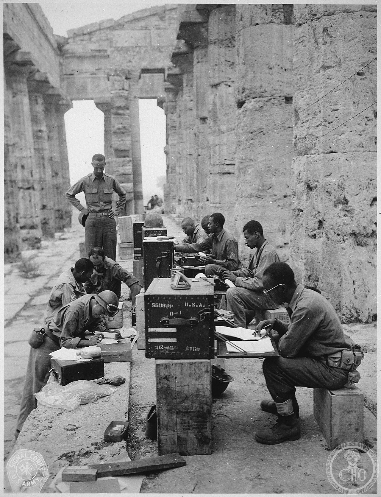
Da Posidonia c.600 BCE a UNESCO 1998 (the most precisely Paestum history: the founding (c.600 BCE: the city of Posidonia was founded by colonists from Sybaris (itself a Greek colony founded by Achaeans from the Peloponnese c.720 BCE): the site was chosen for the flat fertile Piana del Sele plain and the protected anchorage of the Sele river mouth): the Lucanian conquest (400 BCE: the Lucani (an Italic tribe from the Apennines) conquered Posidonia: the city was renamed “Paistos” in the Oscan language (the language of the Lucani): the Greek population was reduced to second-class status but the temples were maintained and used (archaeological evidence shows continuous religious use)): the Roman conquest (273 BCE: Rome established a Latin colony at Paestum: the city was renamed “Paestum”: the Roman colony coexisted with the Lucanian and Greek populations: the Roman forum was built between the two main Greek temples): the Byzantine and medieval period (549 CE: the Saracen raids devastated the city: the population abandoned the coastal city for the inland hilltop settlement (the current Capaccio: 7 km inland): the abandoned city was gradually covered by vegetation and by the rising water table of the Piana del Sele (the malaria swamps of the Cilento coast, which persisted until drainage in the 1920s CE): the temples survived because they were used as sheep pens and later as quarries for building material (the Romans of the later Empire removed marble decorations; medieval inhabitants quarried the stone blocks for buildings in Capaccio and Salerno)): the rediscovery (1745 CE: the first modern description by Felice de Nigris; 1750 CE: the Grand Tour architects (Giovanni Battista Piranesi, Robert Wood) published engravings of the temples: the temples became one of the most visited sites of the Grand Tour (1750-1850 CE); the architect John Soane and the composer Brahms visited Paestum): the UNESCO inscription (1998 CE, reference 842 (“Parco Nazionale del Cilento e Vallo di Diano, con i siti di Paestum e Velia, e la Certosa di Padula”)).
What you see
Il percorso di visita (Via Sacra): Porta Marina (l’ingresso principale sud): Tempio di Era I (“Basilica”, c.550 BCE: 9 colonne × 18 = il numero di colonne insolito: il capitello “a fungo” (il più antico stile dorico)) → Tempio di Poseidone (460-450 BCE: l’edificio meglio conservato: le 2 file di colonne interne ancora in piedi nel cella) → Foro Romano (273 BCE: il basamento del tempio romano; la macellum (il mercato coperto); il tempio romano italo-corinzio) → Tempio di Cerere (Athena, c.500 BCE: le sculture architettoniche in terracotta; le metope dei Silenoio) → Museo Nazionale di Paestum (nel convento domenicano del 1256 CE: le metope del Sele (le sculture del santuario di Era alla foce del Sele); la Tomba del Tuffatore (480-470 BCE: il più importante esempio superstite di pittura greca su tombe; le 5 lastre nel corredo funebre: il simposio + il tuffatore)).
Practical information
- Biglietti: €13 (area archeologica + museo); €7 solo museo; apertura 8:30–19:30 (area); 9:00–19:30 (museo); chiuso il primo e terzo lunedì del mese
- Tempo suggerito: 3–4h totali (area + museo): il museo è essenziale per capire le metope del Sele e la Tomba del Tuffatore
- Best time: maggio-giugno e settembre-ottobre: evitare luglio-agosto (40°C, niente ombra nell’area); buoni stivali o scarpe comode (terreno irregolare)
Getting there
Treno da Salerno (linea Salerno–Reggio Calabria: stazione Capaccio-Paestum; 45-60 min; frequenza ogni 1-2h): con l’auto da Salerno (40 km, 40 min via SS18); aeroporto più vicino: Napoli Capodichino (NAP, 100 km, 1h30 di auto).
Nearby
- Certosa di Padula (60 km): la più grande certosa d’Italia (1306 CE; 1 km di lunghezza; 320 stanze; la cucina da 52 fuochi; la scalinata elicoidale del 1718 CE); UNESCO WHS 1998 (rif. 842 stesso sito di Paestum)
- Velia/Elea (30 km): la colonia greca fondata c.540 BCE dai Focesi: la scuola filosofica eleatica (Parmenide c.515-450 BCE; Zenone di Elea c.490-430 BCE: i paradossi di Zenone); la porta medievale “Porta Rosa” (IV sec. BCE: il più antico arco a tutto sesto d’Italia)
- Costiera Amalfitana (40 km nord): UNESCO WHS 1997; Ravello (Villa Rufolo 1270 CE; Richard Wagner); Positano
Gallery

Sources
- UNESCO World Heritage List: “Cilento and Vallo di Diano National Park with the Archeological Sites of Paestum and Velia, and the Certosa di Padula”, rif. 842 (whc.unesco.org/en/list/842)
- Museo Nazionale di Paestum (museopaestum.beniculturali.it)
- Zancani Montuoro, Paola & Zanotti-Bianco, Umberto: “Heraion alla Foce del Sele”, Istituto Poligrafico dello Stato, Roma 1951-1954
- Sestieri, Pellegrino Claudio: “Paestum”, Istituto Poligrafico, Roma 1967
Find it on the map
See this place and what’s around it →📷 Diventa un fotografo di Cultural Heritage Online
Condividi le tue foto dei luoghi: restano pubblicate con la tua firma come autore. Più vengono viste, più ti fai conoscere — e presto un concorso premierà le foto più apprezzate.
Accedi o registrati gratis per aggiungere una fotoDo you manage this place?
This page is read by travellers and heritage enthusiasts who find it on Google. Keep it accurate — and make it work for you. Free for non-profit heritage institutions.