Ouadi Qadisha and the Forest of the Cedars of God
The last major grove of the legendary Lebanon Cedar and one of the oldest continuously occupied Christian sacred landscapes in the world — the Forest of the Cedars of God above Bcharre in north Lebanon contains ancient trees venerated since antiquity (the wood that built Solomon’s Temple and the Phoenician fleet), while the Qadisha Valley below is lined with cliff-face monasteries and hermit caves inhabited by Christian communities since the 4th century AD.
At a glance
The UNESCO WHS of Ouadi Qadisha and the Forest of the Cedars of God (reference 1107; inscribed 1998) encompasses two linked sites in the northern Mount Lebanon range: the Qadisha Valley (Ouadi Qadisha; from the Aramaic/Syriac word for “holy”; a deep limestone gorge approximately 35 km long running east–west from the village of Bcharre to the coastal plain near Tripoli) with its ancient Christian monastic heritage; and the Horsh Arz el-Rab (Forest of the Cedars of God; the most famous surviving grove of Cedrus libani, the Lebanon Cedar; approximately 2 km above the town of Bcharre at 1,850–2,100 metres altitude on the western slope of the Qadisha Valley); Bcharre (population approximately 4,000; 120 km north of Beirut; approximately 1,400 metres altitude) is the gateway to both sites and the birthplace of the poet Khalil Gibran (1883–1931; the most widely read Arab author of the 20th century; his masterwork The Prophet (1923) has been translated into more than 100 languages and has never gone out of print; the Gibran Museum in the Mar Sarkis and Bakhos Monastery in Bcharre holds his personal collection and is his burial place).
Key facts
- The Lebanon Cedar (Cedrus libani) and the biblical trade: the most symbolically loaded tree in the ancient Near East — the Lebanon Cedar (Cedrus libani; an evergreen conifer of the family Pinaceae; it can live for 3,000 years and grow to 40 metres; the timber is highly aromatic, naturally resistant to insects and decay, and exceptionally durable) was the primary source of timber for the civilisations of the ancient Near East (Egypt, Mesopotamia, Phoenicia, Israel) for at least 5,000 years; the Egyptians imported Lebanese cedar for the masts and hull planks of their ships and for the coffins of the pharaohs (cedar timber has been found in Egyptian tombs dating to 2,600 BC); the Phoenicians of Byblos and Sidon built their famous merchant ships from Lebanon cedar (the Phoenician trade networks — which spread the Phoenician alphabet to Greece, and Phoenician colonists to Carthage, Cadiz, and Malta — depended on cedar shipbuilding); the most famous cedar use in the Bible is in the construction of Solomon’s Temple in Jerusalem (First Kings 5–7: King Solomon asks King Hiram of Tyre for cedar logs; Hiram sends 10,000 men a month to Lebanon to cut the timber; the entire cedar population of Lebanon was progressively reduced by this demand, from an estimated 500,000 hectares in antiquity to approximately 2,000 hectares today; the Cedars of God grove at Bcharre is the most famous of the very few remaining virgin stands); the Lebanese cedar appears on the national flag of Lebanon
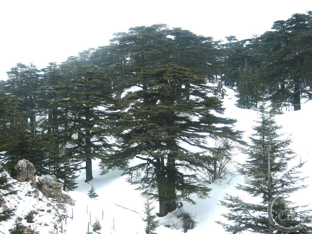
- The Horsh Arz el-Rab (Forest of the Cedars of God): the most visited and most venerated cedar grove in Lebanon — the grove at Bcharre contains approximately 375 living cedar trees in a fenced reserve of approximately 102 hectares at 1,850–2,100 metres altitude; the forest is managed by the Tannourine and Bcharre municipalities and the Ministry of Environment of Lebanon; access is on foot on marked paths (the grove is open daily in summer; in winter it is covered in snow, which the cedars are adapted for — the snow melts in spring to feed the Qadisha River); the 12 largest and oldest trees are estimated to be 1,000–3,000 years old (the age estimates are imprecise because cedar rings are difficult to read accurately at this age; the most likely oldest trees are approximately 1,500–2,000 years); the sacred grove was described by Lamartine (who visited in 1832), by the Victorian explorer Lady Hester Stanhope, and by Gibran himself; a Maronite ceremony is held in the grove annually on the Feast of the Transfiguration (6 August); the grove is also subject to restoration — thousands of cedar saplings have been planted in the surrounding areas in recent decades by the Lebanese NGO Friends of the Cedar
- The Qadisha Valley and early Christian monasticism: one of the oldest continuously inhabited Christian sacred landscapes in the world — the Qadisha Valley was settled by early Syriac Christian communities (Syriac Christianity, which uses the Syriac language — a dialect of Aramaic, the language of Jesus — as its liturgical language, was one of the most important forms of early Christianity; the Maronite Church of Lebanon is a branch of Syriac Christianity in communion with Rome) from the 4th century AD; the sheer limestone cliffs of the valley wall (up to 250 metres high) were carved into hermit cells and then developed into full cliff-face monasteries; the most important monasteries in the valley are Deir Qannoubin (the most ancient; the patriarchal seat of the Maronite Church was here from 1440 to 1823; built into a natural cave in the cliff face; the tombs of the Maronite patriarchs are cut into the rock), Qozhaya (with the most accessible collection of rock-cut rooms and a small museum; a printing press from 1585, the first printing press in the Middle East, is displayed in the monastery), and Mar Elisha (a Carmelite monastery in the valley floor; founded 1695; still inhabited by monks); the valley is accessible on foot by a multi-day trail (the Qadisha Trail; 3 days from Bcharre to the coast) or by jeep on a rough road
- Heritage: UNESCO World Heritage Site, Ouadi Qadisha and Forest of the Cedars of God, inscribed 1998
- GPS: 34.2500° N, 36.0500° E
History
Cedar wood from Lebanon exported to Egypt from at least 2600 BC; the forests supplied Phoenician shipbuilders for millennia; the Assyrians and later rulers continued deforestation; the Maronite Christian community settled the Qadisha Valley from the 4th century AD (the Maronites took their name from the 4th-century Syrian hermit Saint Maron); the Maronite Patriarchate resided in the valley from 1440 to 1823; the Druze-Maronite conflicts of the 17th–19th centuries centred in part on the Bcharre area; the poet Khalil Gibran born in Bcharre 1883; the remaining cedar groves were protected from cutting in the 19th century by a Maronite patriarch’s decree; UNESCO WHS 1998.
What you see
The cedar grove (well-signed walking paths; English signage; the largest oldest trees are marked; a cedar stump section in the visitor area shows the ring structure; views across the Bcharre valley to the snow-capped peaks of the Mount Lebanon range); the Deir Qannoubin monastery (accessible by a steep path from the valley road; the cliff-face setting is extraordinary — the monastery is essentially a series of rooms cut into a cave in the rock face, plastered and frescoed; the Maronite patriarchs’ tombs are in the cave itself); the Gibran Museum in Bcharre (a Maronite monastery converted into a museum; Gibran’s paintings, personal objects, manuscripts, and library; his stone tomb in the garden rock; one of the most visited museums in Lebanon).
Practical information
- Admission and access: Cedar grove admission approximately LBP 100,000 (approximately USD $1.10 at 2026 rates; Lebanese pound has been volatile since 2019; verify locally); open daily approximately 8am–6pm (summer), 8am–4pm (winter); the grove is covered in deep snow from December to March (the Cedars ski resort, one of the oldest ski resorts in the Arab world, is adjacent to the grove; skiing November–April); Qadisha Valley: the monasteries have variable hours (Deir Qannoubin and Qozhaya typically open daily 8am–5pm in summer; phone ahead); the valley walk (from Bcharre to the sea, approximately 35 km; 3 days; well-marked but strenuous) requires a local guide for navigation; day walks in the upper valley are accessible independently
- Getting there: from Beirut: approximately 120 km north (2h 30 min by car via the Jounieh motorway and the Nahr Ibrahim highway; the mountain road section from Byblos to Bcharre is particularly scenic); from Tripoli (the second city of Lebanon; 35 km south-west of Bcharre; 1h by car): regular service taxis run Tripoli–Bcharre in the morning; the road from Tripoli climbs steeply through the Qadisha Valley to Bcharre; note that political conditions in Lebanon can affect road safety and accessibility; verify current conditions before visiting
- Lebanon travel context: Lebanon’s political and economic situation has been volatile since 2019 (the banking crisis, the 2020 Beirut port explosion, and the ongoing political instability); tourism infrastructure in Bcharre and the Qadisha Valley remains largely intact and accessible; the area is distant from the areas of conflict; local accommodation (guesthouses, hotels) is available in Bcharre; the visit is typically combined with Byblos (UNESCO WHS; 70 km south; see separate CHO place card) and Baalbek (UNESCO WHS; 70 km south-east) in a northern Lebanon heritage circuit
Getting there
From Beirut: 120 km north (2h 30 min by car). From Tripoli: 35 km east (1h). GPS: 34.2500, 36.0500.
Nearby
- Byblos (Jbeil) — 70 km south of Bcharre (1h 30 min by car); one of the oldest continuously inhabited cities in the world and the site where the Phoenician alphabet was first used extensively — Byblos (modern Jbeil; Phoenician name Gebal; Greek Byblos; the Greek word for “papyrus book” — biblos — and hence our words “Bible” and “bibliography” derive from the city’s name, as papyrus was traded through Byblos from Egypt to Greece) has been continuously inhabited for approximately 7,000 years (Neolithic settlement c. 5000 BC; Bronze Age Phoenician city; the main trading city for cedar wood to Egypt and for papyrus from Egypt to the Levant; Persian, Hellenistic, Roman, Crusader, and Ottoman layers all visible in the archaeological site and the living city; the medieval Crusader castle is one of the best-preserved Crusader fortifications in the Middle East); UNESCO WHS along with the city of Baalbek; see separate CHO place card
- Baalbek — 70 km south-east of Bcharre (1h 30 min by car via the Bekaa Valley); the largest Roman temple complex surviving in the world — Baalbek (the ancient Heliopolis; “City of the Sun”; in the Bekaa Valley, 1,170 metres altitude; the most fertile valley in Lebanon) preserves the Temple of Bacchus (c. 150 AD; the best-preserved Roman temple in the world outside Rome; the cella walls and columns standing to their full height; the carved reliefs of the doors are the finest examples of Roman baroque carving in existence) and the colossal podium of the Temple of Jupiter Heliopolitanus (one of the three largest Roman temples ever built; the podium stones include the largest worked stones in the world — the “trilithon” blocks, each weighing approximately 1,000 tonnes, remain in place 2,000 years after their laying; how the Romans moved these blocks is still debated); UNESCO WHS 1984; see separate CHO place card
- Ehden and the Horsh Ehden Nature Reserve — 20 km south-west of Bcharre (40 min by car); the best nature reserve in Lebanon outside the UNESCO WHS — the Horsh Ehden Nature Reserve (1 km² of old-growth mixed forest at 1,600–1,800 metres altitude; oak, fir, cedar, juniper, and strawberry tree; the only Lebanese nature reserve with a full-time ranger service) and the picturesque village of Ehden (one of the most beautiful traditional stone-built villages in the Mount Lebanon range; famous for its cherry orchards and the Ehden International Festival of traditional music and dance in July) are the most rewarding complement to the Qadisha Valley visit in the northern mountains of Lebanon
Sources
- Wikipedia, Qadisha Valley; Cedars of God; Cedrus libani; Khalil Gibran, accessed June 2026
- UNESCO, Ouadi Qadisha and Forest of the Cedars of God, WHS reference 1107, inscribed 1998
- Thomas Schipperges, Die Zedern des Libanon, Palmyra Verlag, 2003
Find it on the map
See this place and what’s around it →📷 Diventa un fotografo di Cultural Heritage Online
Condividi le tue foto dei luoghi: restano pubblicate con la tua firma come autore. Più vengono viste, più ti fai conoscere — e presto un concorso premierà le foto più apprezzate.
Accedi o registrati gratis per aggiungere una foto