Ngorongoro Conservation Area
The world’s largest intact volcanic caldera and one of the greatest concentrations of wildlife on Earth — the Ngorongoro Crater in northern Tanzania encloses approximately 25,000 large animals in a natural amphitheatre 260 km² wide and 600 metres deep; the floor of the crater is simultaneously one of the most beautiful landscapes and one of the most dramatic predator–prey theatres in the world, while the surrounding Ngorongoro Conservation Area encompasses the Olduvai Gorge, where the earliest fossil evidence of the genus Homo was found.
At a glance
The Ngorongoro Conservation Area (NCA; 8,292 km²; established 1959 as a multiple-use area from the former Serengeti National Park) is located in the Crater Highlands of northern Tanzania, approximately 180 km west of Arusha (the main city in the region and the usual jumping-off point for northern Tanzania wildlife circuits); the NCA encompasses several distinct zones: the Ngorongoro Crater itself (the star attraction; 260 km² caldera floor + 20 km diameter; reached from the crater rim by a 4WD track — private vehicles not permitted on the crater floor after 6pm; a full-day game drive starting at 7am is the standard visit); the Olduvai Gorge (a steep-sided ravine in the eastern Serengeti Plains where Louis and Mary Leakey worked from 1931 to 1983 and discovered the fossil remains of Australopithecus, Homo habilis, and Homo erectus; one of the most important archaeological sites in the world; a small on-site museum); the Laetoli site (55 km south of Olduvai; the site of the famous Australopithecus afarensis footprints in volcanic ash, c. 3.66 million years BP, the oldest known bipedal footprints in the world; the footprints were discovered by Mary Leakey in 1978 and have been reburied for protection — not visitable, but the story is told in the Olduvai museum); and the Ndutu area (the southern NCA, bordering the Serengeti; the main calving ground for the Serengeti wildebeest in January–March).
Key facts
- The Ngorongoro Crater (caldera): the world’s largest intact and unfilled volcanic caldera — the Ngorongoro Crater is the collapsed caldera of a volcano that became dormant approximately 2–3 million years ago (the caldera formation date is uncertain; the current best estimate is approximately 2.5 million years BP, when the roof of the magma chamber collapsed into the emptied chamber); the caldera is 20 km in diameter; the rim forms a circle of hills rising to 2,286 metres above sea level on the highest point (Olmoti rim); the crater floor is at approximately 1,680 metres; the height difference between the crater floor and the highest point of the rim is thus approximately 600 metres; the crater floor (approximately 260 km² of savanna, woodland, swamp, and a shallow soda lake, Lake Magadi) is not enclosed — there is no continuous physical barrier between the crater floor and the surrounding NCA — but in practice the combination of the steep caldera walls and the lush grazing inside the crater means that approximately 80% of the animal population never leaves the crater floor; the population is self-contained enough that it has developed genetic distinctives (the lion population of the crater, isolated since approximately 1980 when a massing of biting flies killed all but a handful of lions, is one of the most genetically inbred large carnivore populations in the world — all of the current 60–75 lions are descended from a tiny founding population that recolonised from outside after the flies died off)
- The big five and the critically endangered black rhinoceros: the most complete “big five” population in East Africa — the Ngorongoro Crater is one of the very few places in East Africa where all five of the traditional “big five” (lion, African elephant, Cape buffalo, black rhinoceros, and leopard) can be reliably seen in a single day’s drive; the critically endangered black rhinoceros (Diceros bicornis) is particularly significant: the NCA population of approximately 26 black rhinos is one of the last remaining wild black rhino populations in Tanzania; the NCA is a key conservation site for the species; the black rhino population in the crater (always between 20 and 30 animals) has been monitored by individual identification for decades and is known to be slowly growing; the crater also holds the highest density of lions in Africa (approximately 60–75 lions in an area of 260 km² — approximately 1 lion per 4 km², compared with 1 per 25–50 km² in most savanna parks)
- Olduvai Gorge and human evolution: the site where the fossil history of the human genus was established — the Olduvai Gorge (approximately 50 km from the Ngorongoro Crater; a steep gorge cut by streams into the Serengeti Plains with exposed sedimentary layers spanning 2 million years) is where Louis Leakey (1903–1972) and Mary Leakey (1913–1996) conducted their most important fossil discoveries; in 1959, Mary Leakey found the first Paranthropus boisei (initially called Zinjanthropus; “Zinj” in the team’s shorthand; Australopithecus boisei in modern classification; a robust australopithecine with a sagittal crest and massive jaw; dated to 1.8 million BP), which was the Leakeys’ first major find and brought international attention to Olduvai; in 1960, Jonathan Leakey found the fossils of Homo habilis (the first member of the genus Homo recognised from Africa; dated to approximately 1.75 million BP; the fossil evidence for Homo habilis — small brain but human-like teeth and hand bones, associated with the earliest stone tools, the Oldowan culture — is stronger at Olduvai than anywhere else in the world)
- Heritage: UNESCO World Heritage Site, Ngorongoro Conservation Area, inscribed 1979 (extended 2010)
- GPS: -3.1628° S, 35.5832° E
History
The Ngorongoro Highlands were Masai territory from the 17th century; German colonial administration created a game reserve in the 1890s; after World War I, British Tanganyika continued the reserve; the first European to describe the crater was the German explorer Oskar Baumann (1894); game hunting was the primary use through the early 20th century; the NCA was carved out of the Serengeti National Park in 1959 to allow continued Masai pastoralism inside the boundary; UNESCO WHS inscription 1979; Louis and Mary Leakey worked at Olduvai Gorge from 1931 to 1983; the crater lion population was nearly eliminated by a biting-fly epidemic in 1962 and recovered slowly from a bottleneck of perhaps 10 individuals; UNESCO inscription extended 2010 to better recognize the Olduvai/Laetoli Outstanding Universal Value.
What you see
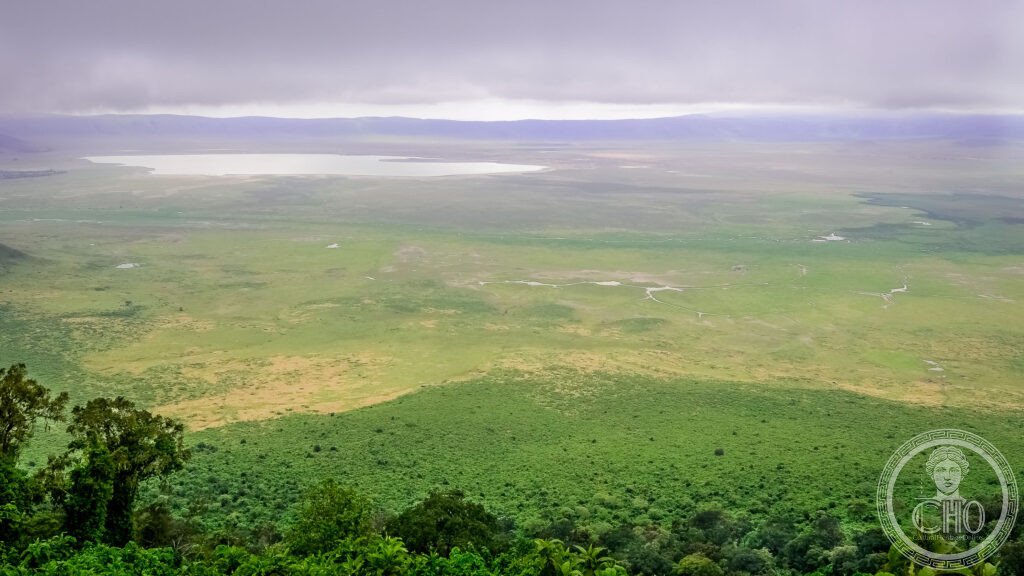
The standard Ngorongoro experience starts with the descent into the crater on the 4WD track from the rim (the first view of the crater floor from the rim, looking down 600 metres onto the golden savanna and the flat shimmer of Lake Magadi, is one of the most spectacular moments in African wildlife tourism); the game drive on the crater floor typically encounters lion (the lions rest on the savanna road edges in the morning; the density means encounters are near-certain), black rhinoceros (the 20–30 individuals are spread across the crater; sightings are not guaranteed but are frequent — approximately 60–70% of full-day drives encounter at least one), elephant (a large resident herd), Cape buffalo (herds of several hundred), wildebeest and zebra (permanent crater residents; supplemented by the wildebeest migration passing through in June–July), hippopotamus (in the Mandusi hippo pool near the lake), and flamingos (on Lake Magadi in some seasons); the afternoon ascent on the opposite rim road gives a second panoramic view of the crater.
Practical information
- Fees: the NCA charges separate fees from national parks: Conservation Fee (USD $70.80/person/day for non-residents; 2026 tariff — Tanzania has a complex multi-part fee structure); vehicle fee; crater service fee; all these together make a full-day Ngorongoro Crater visit approximately USD $120–150 per non-resident adult in addition to accommodation costs; these fees fund conservation and the Ngorongoro Conservation Area Authority (NCAA)
- When to go: the crater is accessible year-round (unlike some Tanzania parks that close in the long rains); the dry season (June–October and January–February) gives the best visibility and road conditions; January–March is the calving season for wildebeest on the nearby Ndutu plains (the most dramatic wildlife spectacle after the main wildebeest crossing; lions, cheetah, and hyena in intense hunting mode); the short rains (November–December) bring green vegetation and fewer tourists but some road closures on the steeper crater tracks
- Getting there: from Arusha (approximately 180 km west; 3h by road; the main approach route passes through Karatu, the gateway town with several good mid-range lodges); from Kilimanjaro International Airport (approximately 200 km; the main international airport for northern Tanzania safari circuits; served by direct flights from Amsterdam, London, Dubai, Nairobi, and Addis Ababa); the crater is typically combined with the Serengeti in a 5–7 day northern Tanzania circuit (Arusha → Tarangire → Ngorongoro → Serengeti is the classic route)
Getting there
From Arusha: 180 km west by road (3h); from Kilimanjaro International Airport (200 km). Combined with Serengeti in the classic northern Tanzania circuit. GPS: -3.1628, 35.5832.
Nearby
- Serengeti National Park — 80 km west of the Ngorongoro Crater via the Naabi Hill gate (1h 30 min by road); the world’s most famous wildlife migration — see separate CHO place card for full description; from the Ngorongoro Crater, the standard approach is via the NCA road through Olduvai Gorge to the Naabi Hill gate, then into the Serengeti; most visitors do Ngorongoro first (2 nights, one full day in the crater) then continue west into the Serengeti (3–5 nights)
- Tarangire National Park — 140 km east of Ngorongoro (3h by road via Arusha); the most underrated national park in northern Tanzania — Tarangire (2,600 km²; a 3h drive south-east of Arusha) is the park with the highest density of elephants in Tanzania (up to 3,000 elephants congregate around the Tarangire River in the dry season, July–October) and arguably the most beautiful landscape of any northern Tanzania park (the Tarangire River, lined with ancient baobabs, yellow fever acacias, and riverine forest, with the pink hills of the Masai Steppe in the background); the park is much quieter than the Serengeti or Ngorongoro; birding is exceptional (over 550 species; the largest concentration of breeding birds of any park in Africa according to some surveys)
- Lake Natron — 160 km north of Ngorongoro (3h by road through the Great Rift Valley); the world’s most important flamingo breeding site — Lake Natron (a shallow, highly alkaline and saline lake in the Rift Valley on the Tanzania-Kenya border; the caustic sodium carbonate-rich water kills most animals but provides the flamingos with a breeding site inaccessible to predators; the lake’s surface temperature can reach 60°C; the salt crust calcifies animals that die there, producing the haunting crystallised bird carcasses photographed by Nick Brandt in 2013) is the most important breeding site in the world for the Lesser Flamingo (Phoeniconaias minor; approximately 1.5–2 million birds breed here in good years, representing approximately 75% of the world population of the species); the lake is also overlooked by the active Ol Doinyo Lengai volcano (3,188 m; the only active carbonatite volcano in the world; the lava is cool enough to flow at 510°C rather than the typical 1,100°C of basaltic lava, and is black when molten but turns white on cooling — the Masai consider it a sacred mountain, “Mountain of God” in Maa language)
Sources
- Wikipedia, Ngorongoro Conservation Area; Ngorongoro Crater; Olduvai Gorge; Laetoli, accessed June 2026
- UNESCO, Ngorongoro Conservation Area, WHS reference 39, inscribed 1979 (extended 2010)
- Ian and Oria Douglas-Hamilton, Among the Elephants, Viking Press, 1975 (early NCA research)
- Mary Leakey, Disclosing the Past, Weidenfeld and Nicolson, 1984
Find it on the map
See this place and what’s around it →📷 Diventa un fotografo di Cultural Heritage Online
Condividi le tue foto dei luoghi: restano pubblicate con la tua firma come autore. Più vengono viste, più ti fai conoscere — e presto un concorso premierà le foto più apprezzate.
Accedi o registrati gratis per aggiungere una foto