

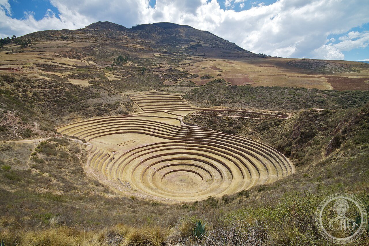
The Inca built a research station inside a natural sinkhole: concentric circular terraces that create 15°C of temperature difference between top and bottom — a living laboratory for developing crops to feed an empire of 12 million people across 5,000 metres of altitude.
At a glance
Moray is an Inca archaeological site located at 3,500 metres altitude on the Sacred Valley plateau, 50 km northwest of Cusco. It consists of three main groups of concentric circular terraces built into natural karst depressions (sinkholes), creating bowl-shaped structures that descend up to 30 metres through up to seven terraced levels. The site is unique in the Inca world: no other comparable structure is known, and its function is not recorded in any written source (the Inca had no writing system). Archaeologists now broadly interpret Moray as an agricultural research station — a place where Inca scientists experimented with crop cultivation under systematically varying temperature and humidity conditions.
Key facts
- Altitude: 3,500 m above sea level (Sacred Valley plateau)
- Main bowl: ~220 m diameter, ~30 m deep, 7 concentric terraced levels
- Temperature range: up to 15°C difference between top and bottom terrace
- Equivalent altitude range: the thermal gradient simulates ~3,000 m of altitude change
- Period: c. 1400–1534 AD (late Inca Empire)
- Function (interpreted): agricultural research station for crop development
- Distance from Cusco: 50 km northwest, ~1.5 hours by road
History
The Inca Empire (Tawantinsuyu) stretched from modern Colombia to central Chile, encompassing one of the most vertically varied landscapes on earth: coastal deserts at sea level, sierra valleys at 2,000–3,500 m, altiplano grasslands at 3,800–4,200 m, and high-altitude puna at 4,500–5,000 m. Feeding an empire of an estimated 12 million people across this vertical range — without money, markets, or wheeled transport — required mastery of dozens of agricultural micro-environments and the ability to develop crop varieties suited to each zone. State granaries (qollqas) stored food for redistribution; state farms (with mit'a labour) produced crops for the army and administration. Moray appears to have been part of the agricultural research infrastructure that made this system possible.
The site has no Quechua name recorded in colonial sources, and the Spanish colonial records make no mention of it as a functioning institution — suggesting it was abandoned or its purpose was not understood at the time of the conquest. The name "Moray" is the name of the modern village nearby. The agricultural research interpretation was developed by archaeologists in the 20th century based on the physical evidence: the precise thermal gradient created by the concentric bowl design, irrigation channels fed from sources outside the depression, and the variety of crop residues (including many wild and cultivated plants) found at different terrace levels during excavation.
What you see
The largest of three bowl sites is the most visited and the most photogenic: seven concentric terraces of fitted stone descend into a circular depression approximately 220 metres across, converging on a flat circular floor. The fitted stone retaining walls of each terrace are typical of Inca agricultural construction — carefully shaped, unmortered, slightly battered — but the circular geometry is unique. Two smaller bowl sites nearby (Cheqoq and Mluchayoc) are less intact. Irrigation channel traces are visible on the hillside above the main bowl. The site has a small visitor centre with explanatory panels.
Practical information
Moray is usually visited as part of the Sacred Valley circuit from Cusco. The site is open daily; entry requires a Cusco Tourist Ticket (Boleto Turístico del Cusco), which also covers Ollantaytambo, Pisac, Chinchero, and other sites in the valley. At 3,500 metres, altitude acclimatisation is essential — spend at least one full day in Cusco (3,400 m) before visiting. The climate is dry and sunny in the dry season (May–October, recommended); wet season (November–April) can make the terraces slippery.
Getting there
From Cusco: take a taxi or organised tour (approximately 1.5 hours via the road through Maras); alternatively, join a group Sacred Valley tour that combines Moray with the Maras salt pans (Salineras de Maras, 5 km away). Public transport is limited: minibuses run from Cusco's Qorikancha area toward Urubamba; ask to be dropped at the Moray turnoff and walk or hire a mototaxi from Maras. The nearest airport is Alejandro Velasco Astete International Airport, Cusco (CUZ).
Nearby
- Salineras de Maras — 5 km east; Inca salt evaporation pans still in use today, producing pink salt from a saltwater spring; one of the most visually striking agricultural landscapes in the Andes
- Ollantaytambo — 30 km southeast; the best-preserved Inca town in existence, with original street grid still inhabited and a massive hilltop fortress; gateway to the Inca Trail to Machu Picchu
- Chinchero — 20 km southeast; Inca market town with colonial church built over an Inca palace; famous for traditional weaving
- Pisac — 45 km east; Inca citadel with impressive agricultural terracing above the Sacred Valley market town
Sources
- Earls, J. (1989). "The Structure of Inca Agriculture." In Archaeological Thought in America, ed. C.C. Lamberg-Karlovsky. Cambridge University Press.
- Kendall, A. (1985). Aspects of Inca Architecture. British Archaeological Reports.
- Ministerio de Cultura del Perú — Boleto Turístico del Cusco: site information.
- Bauer, B.S. (2004). Ancient Cuzco: Heartland of the Inca. University of Texas Press.
- Wikipedia: "Moray (Inca ruin)" — consulted June 2026.
Do you know more?
On this page we have published what we were able to verify. If you know Moray first-hand — you work there, have studied it, or remember how it used to be — and can add a detail, a date, a story or an old photograph, write to Sofia, who looks after these pages. Photographs of the place are welcome too: you can send them with the form at the bottom of this page.
Write to Sofia or send a message on WhatsApp
Please start your message with the title of this page, so it reaches the right file. Every contribution is checked against independent sources before it goes on the page, and we always say where a piece of information came from.
Find it on the map
See this place and what’s around it →📷 Become a Cultural Heritage Online photographer
Share your photos of places: they stay published under your name as the author. The more they're seen, the more you get noticed — and soon a contest will reward the most appreciated photos.
Log in or sign up free to add a photo