Maiden Castle
The largest Iron Age hillfort in Europe — 47 hectares of Dorset downland enclosed by multiple concentric ramparts whose western entrance system, designed to disorient and destroy attackers, anticipated principles of Early Modern European fortification. A site occupied and sacred for 4,500 years, from Neolithic enclosure to Roman temple.
At a glance
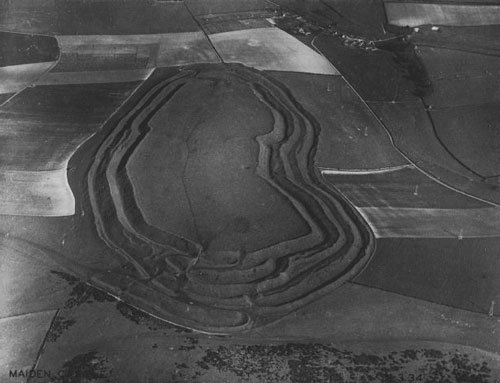
On a chalky hilltop 3km southwest of Dorchester in Dorset, the earthworks of Maiden Castle extend across 47 hectares of downland — roughly the area of 60 football pitches — in a system of multiple concentric ramparts and ditches so immense that the full extent of the site can only be grasped from the air. The outermost earthwork circuit is approximately 3km in circumference. At its western entrance, the ramparts are arranged in a deliberately confusing maze of overlapping banks and passages designed to channel attackers into kill zones and prevent cavalry movement: a defensive system so sophisticated that military historians studying it in the 20th century described it as anticipating principles of 17th-century bastion fortification theory.
Maiden Castle is not simply an Iron Age hillfort. The hill has been occupied, modified, and regarded as significant for approximately 4,500 years: from a Neolithic causewayed enclosure of c. 3500 BC, through a 545-metre-long Neolithic bank barrow of extraordinary scale, through successive Iron Age phases of rampart construction and expansion, to the Roman assault of 43–44 AD and a late Roman temple of 367 AD — one of the longest occupation sequences at any single site in Britain.
Key facts
- Area enclosed: approximately 47 hectares (the largest hillfort in Europe by enclosed area)
- Outer rampart circuit: approximately 3km in circumference
- First occupation: Neolithic causewayed enclosure, c. 3500 BC
- Bank barrow: Neolithic long barrow c. 545 metres long, one of the longest in Britain
- Iron Age hillfort phases: c. 600 BC onwards, expanding and elaborating until c. 100 BC
- Iron Age population estimate: 3,000–4,000 people at peak
- Roman assault: c. 43–44 AD (Vespasian’s southern British campaign, Legio II Augusta)
- Late Roman temple: built c. 367 AD at the centre of the hillfort
- Management: English Heritage; freely accessible year-round
History
The hill that would become Maiden Castle first attracted human attention in the Neolithic period, around 3500 BC, when a causewayed enclosure — a characteristic type of Neolithic communal meeting, ritual, and exchange site found widely across Britain and northwestern Europe — was constructed across the hilltop. This was followed, perhaps 500 years later, by the construction of the bank barrow: a linear earthwork approximately 545 metres long and 20 metres wide, running east to west across the summit. The barrow is among the longest in Britain and its function is uncertain — funerary ritual, territorial marking, and cosmological alignment have all been proposed. What is clear is that by the later Neolithic the hilltop was already a place of special significance, set apart from the surrounding landscape and invested with communal labour on a substantial scale.
The hillfort itself began to take shape around 600 BC, when Iron Age communities enclosed the eastern portion of the hill with a single rampart and ditch. Over the following centuries the enclosure expanded westward to cover the full hilltop, and the defences were progressively elaborated: from a single rampart to the multiple concentric rampart-and-ditch system visible today, with the outer rampart eventually reaching approximately 6 metres in height above its ditch. The entrance systems became increasingly complex — the multiple overlapping banks and passages at the east and west gates are among the most sophisticated defensive arrangements known from Iron Age Europe. At its population peak, roughly 100 BC, Maiden Castle was in effect a small town, with evidence for streets, storage facilities, rectangular and circular buildings, and a central area that may have served religious or administrative functions.
The Roman assault was documented by Mortimer Wheeler’s excavations in the 1930s, which revealed a war cemetery near the eastern gate containing the remains of approximately 40 individuals, several with iron ballista bolts embedded in their skeletons or lying beside their bodies. The Roman force — almost certainly Vespasian’s Legio II Augusta — assaulted the hillfort during its rapid conquest of southwestern Britain in 43–44 AD. The community that survived the assault was eventually resettled in the Roman town of Durnovaria (modern Dorchester), 3km to the north. A small Roman-Celtic temple was built at the centre of the abandoned hillfort around 367 AD, suggesting that the site retained religious significance even after its political and military function had ended.
What you see
Approaching Maiden Castle from the car park on the southern access road, the first impression is of scale: the outer rampart rises steeply to a height that dwarfs the approaching visitor, and the full extent of the earthworks — curving away in both directions and disappearing over the hill — gives little sense from ground level of the total area enclosed. The walk up and over the outer rampart is physically demanding; the original ditches at the base, now partially silted, were considerably deeper when cut in the Iron Age, giving the rampart an effective height of perhaps 12–15 metres from ditch bottom to rampart top.
The western entrance, the more complex of the two surviving entrances, is the best place to understand the defensive logic: the banks and passages here branch, converge, and overlap in a way that would have made it impossible for an attacker in formation to maintain direction or momentum. The interior of the hillfort is now open downland grazed by sheep, with no standing structures, but earthwork traces of internal features are visible in low-angle light, and the site of the Roman temple — indicated by a low square earthwork near the centre — can be located on foot. The views from the interior across the Dorset countryside in all directions are extensive.
Practical information
- Access: freely accessible year-round; no admission charge to the earthworks
- Management: English Heritage (site guardian)
- Parking: small English Heritage car park on the southwestern access road, approximately 600 metres from the western entrance
- Terrain: steep grassy earthworks; good walking shoes essential; can be slippery when wet
- Duration: Allow 1.5–2 hours minimum to walk the full perimeter and explore both entrance systems
- Facilities: information panels at the car park; no visitor centre or café on site
Getting there
Maiden Castle lies approximately 3km southwest of Dorchester, Dorset. By car from Dorchester town centre: follow signs to Maiden Castle via Maiden Castle Road — the English Heritage car park is at the end of a minor road off the A354. By foot: a well-marked footpath leads from Dorchester town centre (approximately 45 minutes each way) via the Cerne Abbas road. Dorchester South and Dorchester West stations are served by South Western Railway from London Waterloo (approximately 2h 30min) and by Great Western Railway from Bristol and Exeter.
Nearby
- Dorchester (3km north): Roman Durnovaria — the Dorset County Museum holds finds from Maiden Castle and one of the finest Romano-British collections in southwestern England
- Cerne Abbas Giant (20km north): 55-metre chalk-cut figure of disputed date (now dendrodated to c. 700–1100 AD), carved into a hillside in the North Dorset Downs
- Durdle Door and Lulworth Cove (20km southeast): iconic coastal landforms on the Jurassic Coast UNESCO World Heritage Site
- Maumbury Rings (1.5km northeast): Neolithic henge monument in Dorchester, later converted to a Roman amphitheatre — the nearest major prehistoric site to Maiden Castle
Sources
- Wheeler, R.E.M. (1943). Maiden Castle, Dorset. Reports of the Research Committee of the Society of Antiquaries of London, No. XII.
- Sharples, N. (1991). Maiden Castle: Excavations and Field Survey 1985–6. English Heritage Archaeological Report No. 19.
- Wikipedia: Maiden Castle, Dorset
- English Heritage: english-heritage.org.uk
Find it on the map
See this place and what’s around it →📷 Diventa un fotografo di Cultural Heritage Online
Condividi le tue foto dei luoghi: restano pubblicate con la tua firma come autore. Più vengono viste, più ti fai conoscere — e presto un concorso premierà le foto più apprezzate.
Accedi o registrati gratis per aggiungere una foto