Hedeby and the Danevirke
At the narrow neck of the Jutland Peninsula, where the Baltic nearly meets the North Sea, a Viking Age trading city and a 30-kilometre frontier wall together defined the edge of the Danish world for over a thousand years. Both are now a UNESCO World Heritage Site.
At a glance
Hedeby (Old Norse: Heiðabý; German: Haithabu) was one of the largest trading towns in northern Europe during the 9th and 10th centuries. At its height it held some 1,500–2,000 inhabitants within a semicircular earthen rampart, with workshops producing amber ornaments, antler combs, glass beads, and textiles, and a harbour sealed by a wooden palisade. It was burned and abandoned in 1050 CE. Running across the base of the Jutland Peninsula just to its north, the Danevirke is a series of earthwork rampart lines begun around 737 CE and used as a military frontier until 1864 — a fortification in active service for more than eleven centuries. UNESCO inscribed both as a single serial property in 2018.
Key facts
- UNESCO inscription: 2018, Cultural — criteria (iii) (iv)
- Location: Schleswig-Holstein, Germany, at the base of the Jutland Peninsula
- Period: Danevirke from c. 737 CE; Hedeby from c. 808–1050 CE
- Peak population: c. 1,500–2,000 people (9th–10th century)
- Danevirke total length: c. 30 km across multiple construction phases
- Last military use of Danevirke: 1864 (Second Schleswig War)
- Serial components: 2 — Hedeby (Haithabu) and the Danevirke
- Museum: Viking Museum Haithabu (Wikinger Museum Haithabu), Busdorf, near Schleswig
History
The Jutland Peninsula creates a land bridge between Scandinavia and Continental Europe, but ships sailing between the Baltic Sea and the North Sea had to navigate the treacherous Skagerrak around its northern tip. Hedeby solved this problem: positioned where the Schlei inlet of the Baltic almost meets the River Treene and Eider system flowing to the North Sea, it became the preeminent transhipment hub of northern Europe. Merchants could unload their cargo, carry or cart it the short distance overland, and reload onto vessels in the other sea — saving weeks and considerable danger.
The town appears to have been founded around 808 CE when the Danish king Godfred relocated Slavic and Frisian merchants from the trading post of Reric to this strategically superior site. Within decades it grew into a cosmopolitan centre drawing Frankish, Anglo-Saxon, Byzantine, and Arab traders alongside Scandinavians. Arab silver dirhams, Frankish swords, and Rhenish wine all passed through its market.
The Danevirke predates Hedeby. Its earliest phase — confirmed by radiocarbon dating and dendrochronology — was constructed around 737 CE, before the Viking Age as conventionally defined. Danish kings continued to extend and reinforce it through the 8th, 9th, and 12th centuries. The wall effectively marked the southern boundary of the Danish realm, and Hedeby sat inside its protective arc.
Hedeby suffered a first major attack in 994 CE by the Norwegian king Olaf Tryggvason and was sacked again in 1049–1050 CE. A contemporary skaldic poem by Ulf Uggason describes the town in flames: only ash remains of Haithabu. The site was never rebuilt. Its successor, Schleswig, developed a few kilometres to the north on the opposite shore of the Schlei.
What you see
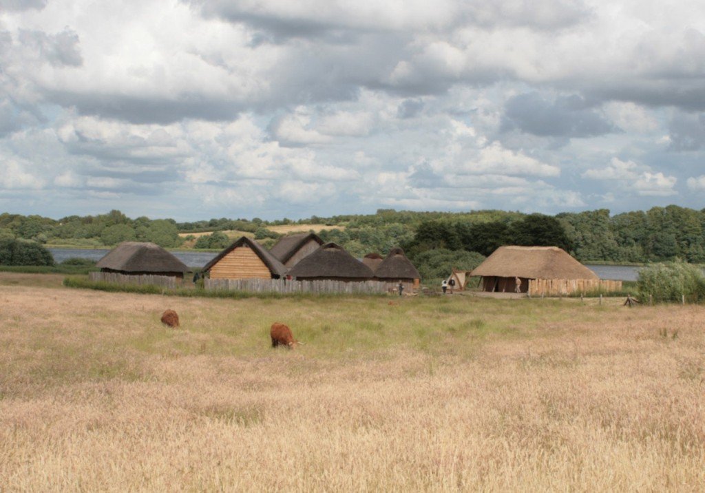
The most visible physical feature at Hedeby is the Halbkreiswall (semicircular rampart), a 1,300-metre arc of earthwork that enclosed the urban area on three sides, with the Schlei forming the fourth. The rampart survives to a height of up to 6 metres and is walkable today. Archaeological excavations since 1930 — and continuing — have revealed wooden plank roads, post-built longhouses, a central well, and extensive craft quarter remains.
The Viking Museum Haithabu (Wikinger Museum Haithabu) adjacent to the site is one of the best Viking Age museums in Europe, displaying original excavated objects — amber beads, bone combs, tools, clothing fragments, coins — alongside reconstructed harbour palisade sections. Four full-scale reconstructed longhouses stand in the field for an immersive sense of scale.
At the Danevirke, the most impressive surviving sections are the Hauptwall (Main Wall) and the Kovirke, a separate southern extension. The scale of the earthwork — in places 20 metres wide at the base — is best appreciated at the Danevirke Museum in Dannevirke village, where a dedicated exhibition traces the full history of the fortification from its Danish Bronze Age precursors through the 1864 war.
Viking Age urbanism
Hedeby is one of only a handful of Viking Age emporia (the others include Birka in Sweden, Kaupang in Norway, and Ribe in Denmark) that can be studied archaeologically in detail. What distinguishes Hedeby is the degree of urban infrastructure revealed: planned street lines, a freshwater supply system, zoned craft production areas, and evidence of a mixed multi-ethnic population. The combination of Hedeby’s urban record with the Danevirke’s political-territorial record makes the serial property exceptionally valuable for understanding how the Viking Age Danish state functioned.
Practical information
- Address: Wikinger Museum Haithabu, Am Haddebyer Noor, 24866 Busdorf (near Schleswig)
- Opening hours: April–October daily; November–March Tuesday–Sunday; check museum website for current hours
- Admission: Charged; combined tickets with Danevirke Museum available
- Danevirke Museum: Ochsenweg 7, 24867 Dannevirke village
- Best season: May–September for outdoor rampart walks and archaeological open days
- Language: Most museum panels in German and English
Getting there
- By car: From Schleswig city centre, follow signs to Haithabu / Wikinger Museum; c. 5 km south on the eastern shore of the Schlei
- By rail: Schleswig station (DB, Hamburg–Flensburg line) + taxi or bike 6 km to museum; a seasonal ferry crosses the Schlei from Schleswig old town directly to the museum
- By ferry: In summer, a passenger ferry runs from Schleswig harbour to the museum landing — the most atmospheric approach
- Nearest airport: Hamburg (HAM) 120 km south; Billund (BLL) 140 km west in Denmark
Nearby
- Schleswig Cathedral (Dom zu Schleswig) — Romanesque-Gothic cathedral in Schleswig city, containing the Bordesholm Altarpiece, one of the largest carved altarpieces in northern Europe
- Gottorf Castle (Schloss Gottorf) — baroque ducal palace now housing the Schleswig-Holstein State Museum and the Nydam Boat (the oldest surviving rowing vessel in the world, c. 320 CE)
- Ribe Viking Center — 80 km north in Denmark, a full-scale reconstruction of an 8th-century Viking Age village at the oldest town in Scandinavia
- Jelling UNESCO World Heritage Site — 90 km north, the runic stones and burial mounds of the Danish royal dynasty that unified Denmark in the 10th century
Sources
- UNESCO World Heritage List — Archaeological Border Landscape of HedeBY and the Danevirke (2018)
- Wikinger Museum Haithabu — official site, haithabu.de
- Danevirke Museum — official site, danevirke-museum.de
- Jankuhn, H. (1986). Haithabu: Ein Handelsplatz der Wikingerzeit. Neumünster: Wachholtz.
- Sindbæk, S.M. (2007). The Small World of the Vikings. Norwegian Archaeological Review 40(1).
Find it on the map
See this place and what’s around it →📷 Diventa un fotografo di Cultural Heritage Online
Condividi le tue foto dei luoghi: restano pubblicate con la tua firma come autore. Più vengono viste, più ti fai conoscere — e presto un concorso premierà le foto più apprezzate.
Accedi o registrati gratis per aggiungere una foto