Grand Canyon National Park
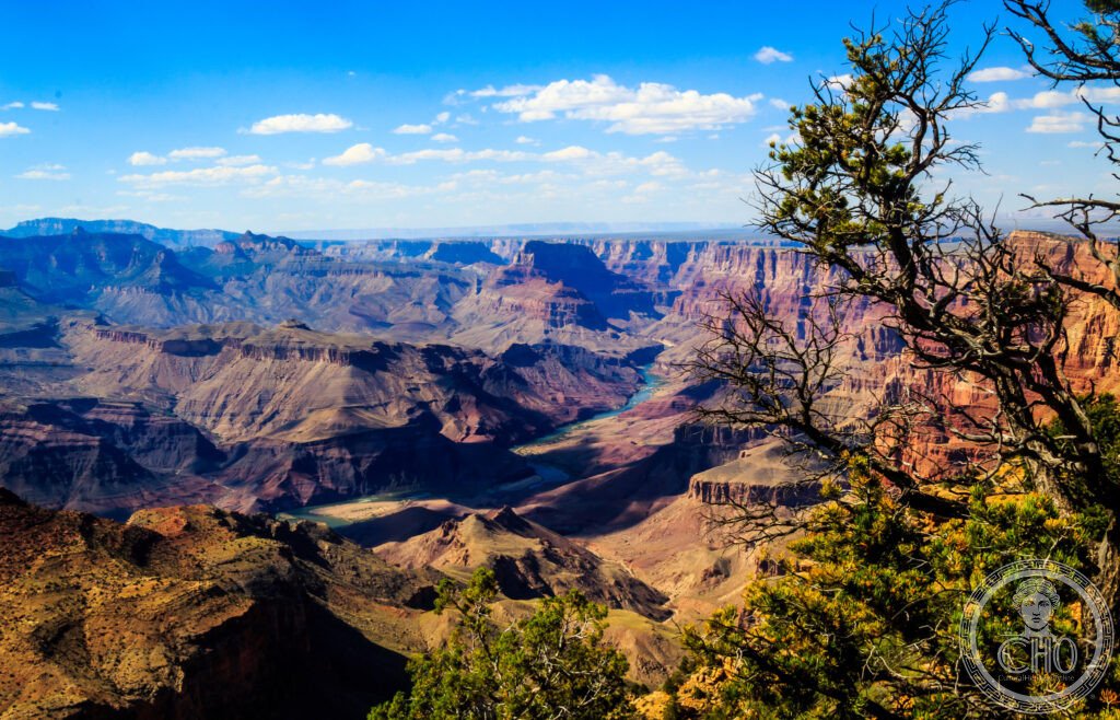
The most visited natural wonder in the United States and the deepest river-carved canyon in the world — the Grand Canyon, in northern Arizona, exposes 1.84 billion years of geological history in a 446-kilometre gash up to 29 kilometres wide and 1,857 metres deep, carved by the Colorado River over approximately 5 to 6 million years.
At a glance
Grand Canyon National Park (UNESCO WHS 1979; approximately 6 million visitors per year (the most visited natural heritage site in the USA; the most visited of all American national parks); established as a national park in 1919 (the 17th US national park; President Woodrow Wilson signed the Grand Canyon National Park Act); previously a National Monument (designated by President Theodore Roosevelt in 1908 after his famous 1903 visit in which he said “Leave it as it is. You cannot improve on it. The ages have been at work on it, and man can only mar it” — the most quoted single statement on the Grand Canyon and the most elegant argument for conservation ever delivered by an American president)); the geology (the most important single fact about the Grand Canyon: the Colorado River has carved through 1.84 billion years of geological history — almost half the age of the Earth — in a single canyon; the Great Unconformity (the most important geological feature in the Grand Canyon: the boundary between the 540-million-year-old Tapeats Sandstone and the 1.84-billion-year-old Vishnu Schist beneath — a gap of approximately 1.2 billion years of missing geological record; the most significant time gap in any exposed geological sequence on Earth; the Great Unconformity is visible to the naked eye at the inner gorge, where dark schist abruptly meets light sandstone — the most visible billion-year gap in the geological record anywhere in the world); the Canyon (the dimensions: 446 km long (end-to-end from Lees Ferry to the Grand Wash Cliffs); up to 29 km wide (the widest point); 1,857 m deep (the deepest point, from the North Rim to the river); total area: 4,926 km²)).
Key facts
- John Wesley Powell and the first river traverse: the most important exploration of the Grand Canyon — John Wesley Powell (1834–1902; the American geologist and explorer; the most important single figure in the exploration of the American West after Lewis and Clark; the first river traverse of the Grand Canyon): the 1869 expedition (the most important river journey in American history; Powell led a team of 9 men in 4 wooden boats from Green River, Wyoming, down the Green and Colorado Rivers through the Grand Canyon; the boats (flat-bottomed wooden dories named Emma Dean, Kitty Clyde’s Sister, No-Name, and Maid of the Canyon — the most romantically named fleet in American exploration history; the No-Name (it kept its original pre-expedition name — the most passive-aggressive boat name in American history)); the losses (the No-Name was wrecked on a rapid; 3 men abandoned the expedition near the end and hiked out through the canyon rim — they were killed by Paiute people the same day the rest of the expedition successfully exited the canyon; the most tragic single-day denouement in American exploration history); the achievement (Powell and the 5 remaining men emerged from the Grand Canyon at the Virgin River on 30 August 1869 — the most important single date in the history of American river exploration; the voyage proved the Colorado was navigable; it opened the Southwest to systematic scientific survey)); the Powell Geographic Surveys (1871–1872 second expedition; the first systematic geological mapping of the canyon; Powell named many of the major geological formations still used today)
- Hiking the canyon: the essential physical experience of the Grand Canyon — the South Rim trails (the Bright Angel Trail (the most popular and safest rim-to-river trail; 15.3 km round-trip to the Colorado River; 1,341 m elevation drop; the Indian Garden oasis (now Havasupai Gardens; the only reliable water source on the Bright Angel Trail; the cottonwood trees; the most welcome shade in the canyon on a summer day) at 7.5 km; Phantom Ranch at the river (the only accommodation below the rim; a historic stone lodge and cabins built by Mary Jane Colter in 1922; the most remote hotel reservation in the USA — bookings open 13 months in advance and fill within minutes of release; the beer at Phantom Ranch after the hike down (the most celebrated post-hike drink in American hiking culture)); the South Kaibab Trail (the most dramatic rim-to-river descent; 12 km round-trip to the river; no shade and no water; the Ooh Aah Point (the most dramatic single viewpoint on the trail at 1.5 km); the Cedar Ridge (the best picnic spot in the canyon; 4.6 km round-trip; the most popular short hike on the South Rim)); the heat warning (the NPS’s most urgent safety message: “Do not hike to the river and back in one day” — the most frequently ignored advice at the Grand Canyon; heat-related rescues peak in June–August; canyon temperatures can exceed 40°C at river level even when the rim is 15°C)
- The Havasu Falls and the Havasupai people: the most spectacular side-canyon in the Grand Canyon — Havasu Canyon (the side canyon of the Havasupai Reservation, approximately 60 km from the South Rim visitor area; the Havasupai people (the “people of the blue-green water”; the most isolated Native American community in the contiguous USA; the tribe that has lived continuously in Havasu Canyon for approximately 800 years; the most tenacious continuous human occupation of any canyon in the American Southwest; the reservation (the Havasupai Indian Reservation; the most restricted Native American land in terms of access: only accessible by a 16-km trail from the canyon rim; helicopter; or mule — no paved road enters Havasu Canyon)); the Havasu Falls (the most beautiful waterfall in the American Southwest; 37 m high; the travertine-blue colour of the water (the most extraordinary natural water colour in the USA: the Havasu Creek carries dissolved calcium carbonate in such concentration that the algae-laden travertine gives the water a spectacular turquoise-blue colour visible from 100 m; the most frequently described “Caribbean blue” of any landlocked waterfall in North America)); the permit system (permits are required and are among the most sought-after in the USA; released annually in February; the most over-subscribed reservation system in American outdoor recreation)
- Heritage: UNESCO World Heritage Site, Grand Canyon National Park, inscribed 1979
- GPS: 36.0544° N, -112.1401° E
History
Human history at the Grand Canyon (the oldest evidence of human occupation near the Grand Canyon: split-twig figurines found in Stanton’s Cave (approximately 4,000 years old; the most ancient human-made objects in the Grand Canyon; their purpose debated — possibly hunting magic); the Ancestral Puebloans (the prehistoric peoples of the Four Corners region; they occupied the Grand Canyon rim and inner canyon approximately 1,000–700 years ago; the Tusayan Pueblo on the South Rim (c.1185 CE; one of the best-preserved Ancestral Puebloan villages accessible to visitors; the most historically significant structure on the South Rim); the Havasupai (see above; the most continuously occupied community in the canyon)); European exploration (the first Europeans at the canyon: García López de Cárdenas (1540 CE; a captain of Coronado’s expedition sent north by Coronado after hearing reports from Hopi people of a great river; he arrived at the South Rim and spent 3 days trying to descend to the river before turning back — the most unsuccessful descent attempt in Grand Canyon history; the party brought with them Hopi guides who knew the canyon but did not share that knowledge with the Spanish); the Ives Expedition (1857–1858; the US Army Corps of Topographical Engineers; the first American government survey of the lower Colorado River)); John Wesley Powell (1869 and 1871–72; see above); the railroad era (the Santa Fe Railway reached the South Rim in 1901; the most important single infrastructure event in the history of Grand Canyon tourism; the arrival of the railway (within 5 years, annual visitor numbers increased from approximately 1,000 to over 20,000; the most rapid growth in any American heritage site before the automobile age)); national park status (1919; UNESCO WHS 1979).
What you see
The Grand Canyon visit (the two rims — the South Rim (the most visited; open year-round; 6 km from the Colorado River directly below; accessible by car, shuttle, and the Grand Canyon Railway from Williams; the best all-around experience; the key viewpoints along the Desert View Drive from the Village to Desert View: Mather Point (the most visited; the first view most visitors have); Yavapai Point (the geology museum at the point); Grandeur Point; The Abyss (the deepest single-drop view from the South Rim); Desert View Watchtower (the most interesting building on the South Rim: a multi-storey Puebloan-style stone tower built by architect Mary Jane Colter in 1932; the finest single building at the Grand Canyon; Colter was the most important architect of the American Southwest style and her buildings at the Grand Canyon — including the Bright Angel Lodge, Lookout Studio, Hopi House, Hermit’s Rest, and the Watchtower — are the most coherent architectural ensemble at any American national park)); the North Rim (open mid-May to mid-October; 1,000 m higher than the South Rim; the fewer visitors (approximately 10% of South Rim attendance); the finest single view: from Point Imperial, the most expansive panorama at the Grand Canyon; the Kaibab Plateau forest (Ponderosa pine and aspen at 2,500 m; the most beautiful forest drive to any national park rim in the USA)); the mule rides (the most traditional canyon experience; mule rides to Phantom Ranch have operated since 1913 — the most continuous commercial tourism experience at the Grand Canyon).
Practical information
- Getting there: Flagstaff Pulliam Airport (FLG; Flagstaff, Arizona; the closest commercial airport; 130 km south (1h 30min); daily flights from Phoenix, Los Angeles, and Denver); Phoenix Sky Harbor International Airport (PHX; 360 km south; 3h 30min drive; the best connection to international flights); the Grand Canyon Railway (from Williams, AZ; 113 km south; 2h scenic train to the South Rim; the most atmospheric arrival at the canyon; the train operates daily; the Williams station is a beautifully restored 1908 depot); the South Rim entrance (USD 35 per vehicle; valid 7 days; annual pass (America the Beautiful; USD 80; covers all US national parks for 1 year — the most value-for-money annual pass in American outdoor recreation)); the shuttle system (the free shuttle buses within the park (the most efficient way to move between viewpoints on the South Rim; cars are extremely limited in parking; the Hermit Road shuttle runs to viewpoints inaccessible to private cars (closed to private vehicles March–November))
- Sedona and the red rock country: the finest desert landscape accessible from the Grand Canyon — Sedona (110 km south of the South Rim; 2h drive; the most visited scenic red-rock town in Arizona; the red Schnebly Hill Formation sandstone (280 million years old; the same geological age as the Coconino Sandstone in the Grand Canyon walls); the Vortex sites (the 4 most famous energy vortex sites in Sedona: Bell Rock (the most photographed isolated rock formation); Cathedral Rock (the most famous Sedona silhouette; the most frequently used image in Arizona tourism marketing); Boynton Canyon (the most forested canyon approach); Airport Mesa (the most accessible and the best 360° view of Sedona)); the Cathedral Rock Trail (the most popular hike in Sedona; 2 km round-trip; 104 m elevation gain; the final scramble over red slickrock; the most rewarding short hike in Arizona); the Oak Creek Canyon (the most dramatic canyon drive in Arizona: a 25-km road descending through red and cream sandstone walls from the rim to Sedona; the swimming holes in Oak Creek (Slide Rock State Park; the most popular natural waterslide in Arizona; natural stone chutes polished by the creek; the most visited swimming hole in Arizona))
- Monument Valley Navajo Tribal Park: the most recognisable landscape of the American West — Monument Valley (320 km north-east of the Grand Canyon (4h drive); the most recognisable landscape in the world for Western films: the isolated sandstone buttes (the Mittens and Merrick Butte; the most photographed rock formations in the American Southwest; used in 7 John Ford Western films, including Stagecoach (1939), She Wore a Yellow Ribbon (1949), and The Searchers (1956) — the most cinematic landscape in North America); the Navajo Nation (Monument Valley is entirely within the Navajo Nation Reservation — the largest Native American reservation in the USA (71,000 km²); the Valley of the Gods, the Navajo Code Talkers; the most photographed and least understood cultural landscape in the American West); the best photograph (the view of the East and West Mitten Buttes from the Visitor Centre overlook at sunrise — the most frequently replicated photograph of any American landscape: seen in hundreds of films, posters, and advertisements, yet still genuinely breathtaking in person))
Getting there
Flagstaff Airport (FLG) 130 km (1h 30min). Phoenix (PHX) 360 km (3h 30min). Grand Canyon Railway from Williams 2h scenic. Entry USD 35/vehicle. GPS: 36.0544, -112.1401.
Nearby
- Zion National Park — 165 km north-west (2h 30min drive); the finest slot canyon and cliff-face hiking in the American Southwest — Zion Canyon (the most vertically dramatic canyon in the USA (the Navajo Sandstone walls of Zion Canyon rise 610 m directly above the canyon floor — the most claustrophobically dramatic canyon in the USA; the wall colours (the cream and red Navajo Sandstone; the desert varnish (manganese-oxide black streaks on the cliff faces — the most distinctive colouration of any sandstone wall in the American West)); the Angels Landing Trail (the most famous dangerous hike in the USA: the final 0.8 km involves climbing a 454-m cliff face using chains bolted into the rock; it is the most frequently discussed risk-reward hiking decision in American national park history; the NPS requires a permit (since 2022) and issues safety warnings that the final section is “not for the faint of heart” — the most diplomatic warning for a trail that has killed approximately 10 people))
- Bryce Canyon National Park — 230 km north (3h 30min drive); the finest hoodoo landscape in the world — Bryce Canyon (the hoodoos (the orange, pink, and red spires of eroded Claron Formation limestone; Bryce Canyon contains the highest concentration of hoodoos in the world — approximately 1.8 million individual spires; the most surreal geological landscape in the American West; the colour (the Pink Cliffs of Bryce are the topmost step of the Grand Staircase geological sequence — the same rocks continue from the Grand Canyon up through Zion to Bryce; the most continuous geological progression visible from any trio of American national parks)); the Navajo Loop and Queen’s Garden Trail (the finest single hike at Bryce; 4.8 km; the descent into the amphitheatre between the hoodoos; the red canyon walls; the Navajo Loop’s Wall Street section (the narrowest corridor between hoodoo walls in Bryce; 3 m wide; 60 m tall; the most claustrophobic hike in Utah))
- Antelope Canyon (Navajo Nation) — 190 km east (2h 30min drive); the most photographed slot canyon in the world — Antelope Canyon (Upper Antelope Canyon (Tse’ bighanilini; “the place where water runs through rocks”); a Navajo-owned slot canyon near Page, Arizona; the most photographed interior landscape in the American Southwest: the narrow sinuous canyon of Navajo Sandstone sculpted by flash floods over thousands of years; the beam of light (the shaft of sunlight that penetrates the narrow slot opening and illuminates the curved orange sandstone walls; visible most dramatically from April to September between 10am and 1pm; the most sought-after photograph in any American canyon (the beam requires specific weather, season, time, and a tripod; the one photograph that justifies the guided tour (required by the Navajo Nation park authority for all visitors)); the Lower Antelope Canyon (Hasdeztwazi; the “spiral rock arches”; narrower and less crowded than the Upper; requires a ladder descent; the more athletic but equally spectacular alternative))
Sources
- Wikipedia, Grand Canyon; John Wesley Powell; Bright Angel Trail, accessed June 2026
- UNESCO, Grand Canyon National Park, WHS reference 75, inscribed 1979
- John Wesley Powell, Exploration of the Colorado River and its Canyons, Smithsonian, 1875
Find it on the map
See this place and what’s around it →📷 Diventa un fotografo di Cultural Heritage Online
Condividi le tue foto dei luoghi: restano pubblicate con la tua firma come autore. Più vengono viste, più ti fai conoscere — e presto un concorso premierà le foto più apprezzate.
Accedi o registrati gratis per aggiungere una foto