Le Dolomiti
The most spectacular example of Triassic coral reef material in the world, compressed by tectonic collision, exposed by glaciation, and eroded into vertical walls and spires — the Dolomites (UNESCO WHS 2009; 141,903 hectares across three regions; 9 distinct massifs) are named after the French geologist Déodat de Dolomieu, who identified the rock type in 1791, and contain some of the most extreme technical climbing walls in the world alongside the most theatrical Alpine scenery in Europe.
At a glance
Le Dolomiti (the most precisely Dolomiti single UNESCO WHS 2009 reference 1237 Natural Outstanding Universal Value 141903 hectares 9 massifs: Pelmo Croda da Lago Marmolada Pale di San Martino San Lucano Dolomiti Bellunesi Vette Feltrine Dolomiti Friulane Dolomiti d Agordino Badia Gader Puez Odle Sciliar Catinaccio Latemar Cortina Bovec Tre Cime di Lavaredo Tre Cime highest North face 2999m 5 Italian regions Veneto Trentino-Alto Adige Friuli-Venezia Giulia 18 municipalities 5 UNESCO criteria: viii outstanding geological processes; ix active geological processes including ice formation erosion unique geomorphological processes; x exceptional natural beauty; xi geomorphological process active ongoing rock fall ice formation vegetation zones: 240 million years old Triassic origin ancient sea floor coral reef material: dolomite rock type CaMg(CO3)2 calcite + magnesium described first 1791 Déodat de Dolomieu French geologist).
Key facts
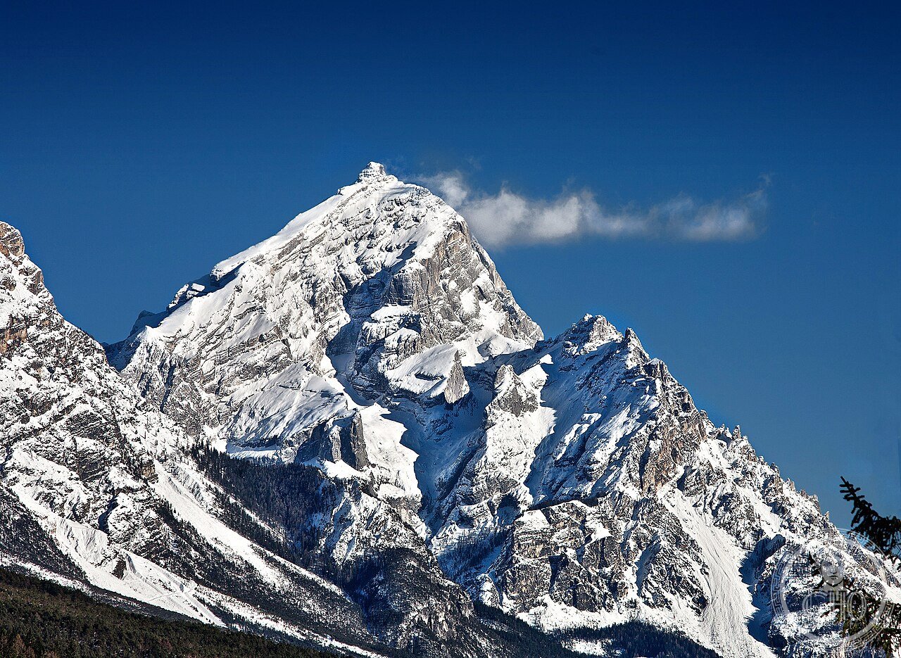
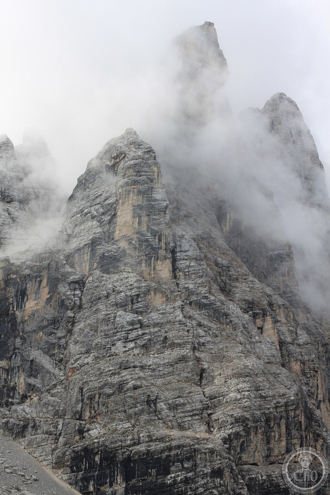
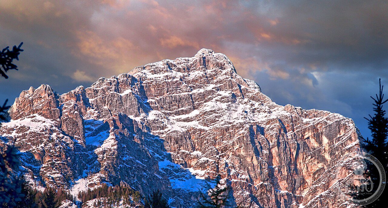
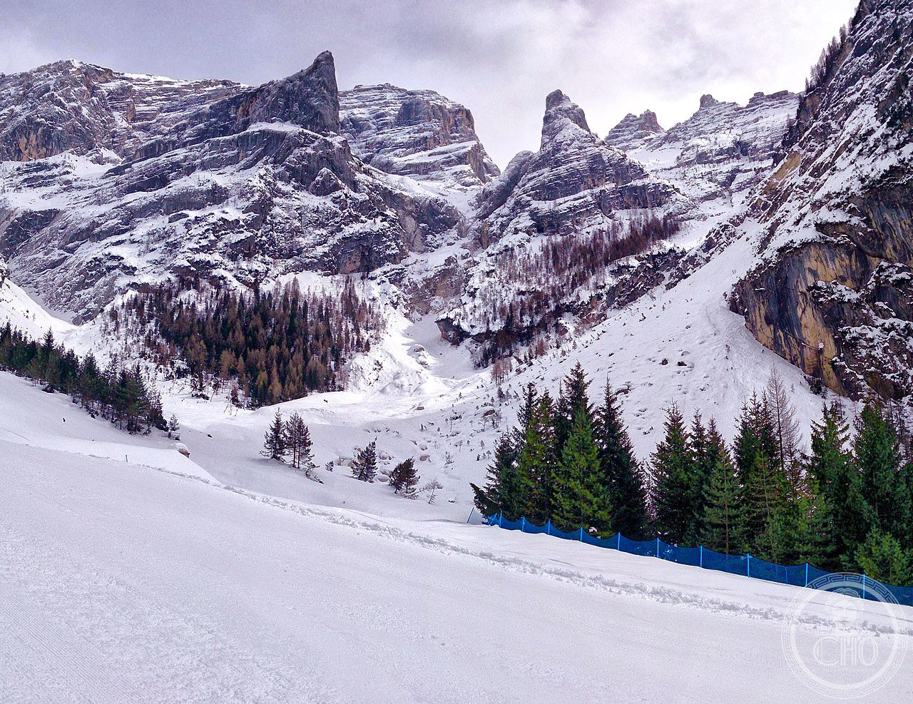
- The Dolomite rock type and why it makes vertical walls (the geology of the most dramatic Alpine scenery in Europe): the Dolomites are made of a specific rock type: dolomite (CaMg(CO₃)₂; calcium magnesium carbonate), which differs from ordinary limestone (CaCO₃) in one crucial way: it is harder, more resistant to acid dissolution, and erodes differently; the rock was formed 240 million years ago as a tropical coral reef in the Tethys Sea (the ancient ocean that would eventually close to form the Mediterranean); the reef material was compressed as the African and European tectonic plates began colliding; it was pushed upward during the Alpine orogeny (50–15 million years ago) to heights exceeding 3,000 m; glaciation (the last ice age; maximum approximately 20,000 years ago) scraped away the surrounding softer rock, leaving the dolomite towers exposed; the key property of dolomite that creates the Dolomite landscape: it resists chemical weathering (acid rain, freeze-thaw cycles attack it less than limestone) but fractures along vertical joint planes when mechanically stressed; the result is near-vertical faces rather than the rounded slopes of limestone Alps; the characteristic pale grey colour turns orange-pink at sunset (the “enrosadira” — the alpenglow effect is intensified in dolomite because the crystal structure reflects warm-spectrum light differently than ordinary limestone — this is a scientific fact, not a romantic legend; the enrosadira can be observed 20-30 minutes after sunset on clear evenings from the Cinque Torri, the Tre Cime, the Catinaccio/Rosengarten, and the Pale di San Martino)
- GPS: 46.4945° N, 12.3035° E (Tre Cime di Lavaredo area, central Dolomites)
History
From 240 million year old tropical reef to WWI front to UNESCO heritage (the most precisely Dolomiti single 240 million years BCE Triassic period Tethys Sea tropical reef calcium magnesium carbonate layers deposited 65 million BCE Alpine orogeny begins Tethys closed African Eurasian collision 50 15 million BCE dolomite massifs pushed upward above 3000m altitude 20000 BCE last glacial maximum glaciers carved valleys exposed vertical faces post-glacial period human habitation valleys Neolithic Bronze Age Ladin people ancient alpine population still inhabiting valleys speaking Rhaeto-Romance language Ladin related Latin 700 BCE Celtic people Venetic people mountain passes traded amber tin copper bronze 15 BCE Roman conquest Raetia province road building mountain passes trade routes Augustine road Brenner Pass 1200 1600 CE medieval period German colonization South Tyrol mining silver copper extraction Belluno Venice territory 1800s CE modern mountaineering era German Austrian British climbers Dolomites exploration Paul Grohmann first ascents Marmolada 1864 Tre Cime 1869 first major rock climbing routes Innerkofler guides Sextener Dolomiten 1914 1918 CE World War I Dolomites became high-altitude front line between Italian and Austrian forces trenches tunnels dug directly into dolomite rock still visible today Pasubio Passo Falzarego Marmolada glacier Austro-Hungarian forces 1916 dug 9km tunnels through glacier called Ice City Città di ghiaccio to protect 12000 soldiers from Italian artillery 2009 CE UNESCO WHS inscription reference 1237 Natural criteria: the Via Ferrata system of WWI (how the Dolomite war created the world’s most developed network of iron-rung climbing routes): the Via Ferrata (iron way; from Latin via ferrata) is a system of fixed iron rungs, cables, and ladders installed on vertical Dolomite rock faces, created during World War I by Austrian and Italian military engineers to allow non-specialist soldiers to cross the high mountain terrain that divided the two armies; the Via Ferrata Cesare Battisti on Monte Pasubio (1917 CE; Italian military; the most famous WWI via ferrata; 6 km of fixed cables crossing four distinct massifs at altitudes between 1,200m and 2,235m) was the longest and most complex military climbing route in the war; after 1919, the military routes were preserved and expanded as civilian hiking infrastructure; the Dolomites today have over 500 named via ferrata routes, making it the most developed iron-climbing network in the world; the concept and name “via ferrata” has been exported to climbing areas in every Alpine country and is now used worldwide for fixed-protection mountain routes)).
What you see
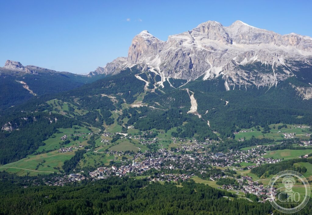
The 9 massifs and the key access points (the most precisely Dolomiti single three most visited areas Tre Cime di Lavaredo Sesto Dolomites north Cortina rifugio Auronzo road 2320m highest drive Dolomites car park Rifugio Auronzo walk 2h circuit around three towers north face vertical 500m drop most photographed viewpoint the lake reflection Laghi dei Piani 30 min from rifugio Marmolada highest Dolomite peak 3343m Fedaia Pass access cable car summer winter largest glacier Dolomites; Pale di San Martino plateau 2589m accessible via cable car from San Martino di Castrozza the largest high plateau the Dolomites flat alpine meadow 1000m above treeline the most otherworldly landscape the most photogenic in horizontal light; Cinque Torri Cortina area 2361m accessible by chairlift near Passo Falzarego 5 towers WWI military museum in situ trenches preserved open air museum best WWI site Dolomites; Catinaccio Rosengarten massif near Bolzano 2981m alpine road summer evening enrosadira the best viewing location for the alpenglow pink-orange light on dolomite; the Ladin villages: the Ladin people (the alpine population speaking the Rhaeto-Romance Ladin language; approximately 20,000 speakers in the Badia, Fassa, Gadertal/Badia valleys; the Ladin culture museum in San Martin de Tor Badia valley; traditional Ladin costume worn at alpine festivals August September): the Dolomite villages maintain a trilingual culture (Italian/German/Ladin) that is unique in the Alps and directly linked to the complex governance history of the mountains).
Practical information
- Getting there: from Venice: car to Cortina d’Ampezzo 2h30m (via A27 Belluno then SS51); from Milan: 3h30m via A4 Bergamo; from Bolzano/Bozen: 1h30m to various massifs; train (Venice to Belluno 2h then bus Belluno to Cortina 2h; Bolzano/Bozen is on the Brenner mainline; frequent connections; bus connections to valleys from Bolzano); best bases: Cortina d’Ampezzo (the most famous resort; central access to Tre Cime, Tofane, Cristallo; expensive but best infrastructure); Ortisei/St. Ulrich (Gröden Valley; Alpe di Siusi plateau access; more affordable; central Ladin culture); Moena/Pozza di Fassa (Fassa Valley; Catinaccio/Rosengarten access; most authentic Ladin village atmosphere); Auronzo di Cadore (closest to Tre Cime; budget accommodation; the best dawn light on the north face 4:30–5:00 AM June–August)); seasons: summer (July–September: hiking; walking the circuit around Tre Cime; via ferrata; mountain biking Alpe di Siusi); winter (December–March: skiing; the Dolomiti Superski area is the largest connected ski area in the world: 1,220 km of pisted runs; 450 lifts across 12 valleys; the Sella Ronda circuit (4 passes; 4 valleys; 26 km; can be skied in 1 day clockwise or anti-clockwise in standard conditions) is the most elegant ski touring route in the Alps); mid-season (May and October): best for photography (no crowds, clear air, wildflowers in May, autumn colours in October); completely different landscapes from July–August peak)
Getting there
From Venice: car 2h30m. From Milan: 3h30m. From Bolzano: 1h30m (train to Bolzano then bus). Best bases: Cortina (central, expensive), Ortisei (affordable Ladin culture), Moena Fassa Valley (Catinaccio access). Sella Ronda ski circuit in winter. Tre Cime circuit 2h walk from Rifugio Auronzo (road toll in summer). GPS: 46.4945, 12.3035.
Nearby
- Bolzano / Bozen — 80 km west (the South Tyrol capital; the Museum of Archaeology housing Ötzi the Iceman (Ötzi; the mummified remains of a 45-year-old Copper Age man (approximately 3,300 BCE; found in 1991 in a Tirolean glacier; the oldest known naturally preserved mummy in Europe; killed by an arrow in the back — the arrowhead still in place; the museum display at 0°C and 98% humidity allows full body viewing; Ötzi’s genome shows he had brown eyes, type 0 blood, was lactose intolerant, and had genetic markers common in modern Sardinian men — the specific combination of ancestral traits is one of the most discussed in modern archaeogenetics); the Walther Platz (the 14th-century civic square; the Christmas market here is one of the oldest and largest in the Alpine region))
- Verona — 150 km south-west (UNESCO WHS 2000; the Arena (1st century CE; the Roman amphitheatre in active use as an opera venue — the summer Arena di Verona opera season (June–August; 14,000 seats; the world’s largest open-air opera stage; Verdi’s Aida and Bizet’s Carmen are the traditional summer productions); the Casa di Giulietta (13th century CE; the balcony associated with Romeo and Juliet; Shakespeare used Verona as setting but the story is a 16th-century Italian novella; the Association of Juliet Secretaries responds to 1,800 letters per week addressed to Juliet from around the world))
Gallery
Sources
- Wikipedia, Dolomites; Tre Cime di Lavaredo; Via ferrata; Dolomite (rock); Ladin people, accessed June 2026
- UNESCO, The Dolomites, WHS reference 1237, inscribed 2009
Find it on the map
See this place and what’s around it →📷 Diventa un fotografo di Cultural Heritage Online
Condividi le tue foto dei luoghi: restano pubblicate con la tua firma come autore. Più vengono viste, più ti fai conoscere — e presto un concorso premierà le foto più apprezzate.
Accedi o registrati gratis per aggiungere una foto