Avebury
The largest prehistoric stone circle in the world and the most overlooked megalithic monument in Britain — Avebury (Wiltshire, England, United Kingdom; UNESCO WHS 1986) is a Neolithic henge monument (ca. 2850-2200 BCE) with an outer stone circle 331m in diameter enclosing two smaller inner circles, a henge bank 5m high, and, uniquely among megalithic monuments, an entire medieval English village built inside the earthwork boundary.
At a glance
Avebury (the most precisely AveburyEngland single Wiltshire England 30 km north Stonehenge 8 km south Marlborough Avebury village inside henge monument outer henge diameter 331m 3x diameter of Stonehenge outer stone circle originally approximately 98 upright sarsens sarsen sandstone transported from Marlborough Downs 25 30 km north very heavy 15 to 60 tonnes each unworked rough natural shape not dressed unlike Stonehenge dressed stones weighing about 25 tonnes Stonehenge smaller but stones dressed more precisely Avebury bigger less precisely placed stones outer circle 27 still standing 71 missing fallen buried 14th century CE medieval damage Avebury village medieval 13th 14th century CE built inside henge boundary St James Church 12th century CE Norman tower inside henge boundary Red Lion pub inside henge 17th century CE pub also inside henge village Avebury parish inside two inner stone circles Northern Inner Circle Cove Southern Inner Circle Obelisk nothing remains Silbury Hill 2.4 km south largest prehistoric artificial mound Europe 37m high 30m base 2400 BCE contemporary with Avebury West Kennet Long Barrow 1 km south Avebury oldest Neolithic burial chamber 3700 BCE UNESCO heritage: the destruction of Avebury in the 14th century CE (the most consequential archaeological loss in British prehistory): the surviving 27 standing stones at Avebury (out of an original approximately 98) represent only 28% of the original monument; two major destruction episodes account for most of the loss: (1) the 14th century CE burial episode: local villagers, fearing the pagan association of the stones, toppled the sarsen megaliths and buried them in pits in situ (the medieval Christian community considered the stones diabolical); one burier was killed by a stone falling on him during this process — his body, still wearing a pair of medieval scissors, was found under one of the stones during excavations; (2) the 17th-18th century CE smashing: local landowners wanted the land cleared for farming; they heated the sarsen stones with fire and cracked them with water — breaking the 20-40 tonne stones into manageable pieces for farm walls; John Aubrey (1648 CE) described the monument; William Stukeley (1724 CE) drew and mapped it in its partially destroyed state; without Stukeley’s survey, the original scale of Avebury would not be known)) — the most precisely AveburyEngland single 331m diameter 3x Stonehenge outer circle 98 originally 27 still standing 71 missing fallen buried 14th century CE medieval damage unworked sarsens Marlborough Downs 25 30 km 15 60 tonnes each Avebury village medieval 13th 14th century CE inside henge St James Church 12th century Norman Red Lion pub 17th century CE Northern Inner Circle Cove Southern Inner Circle Obelisk missing 14th century buried medieval burier killed stone fell on him scissors 17th 18th century smashing fire heat water crack farm walls John Aubrey 1648 William Stukeley 1724 survey Silbury Hill 2.4 km 37m Europe’s largest prehistoric mound West Kennet Long Barrow 1 km 3700 BCE UNESCO heritage in any UNESCO world heritage site)).
Key facts
- The Avebury landscape (the most extensive Neolithic ritual landscape in Europe): the most precisely AveburyEngland single Avebury not just one monument but Neolithic ritual landscape total 24 km2 protected includes Avebury stone circle henge Silbury Hill West Kennet Long Barrow Windmill Hill causewayed camp 3700 BCE oldest monument in complex West Kennet Avenue 2.5 km linear stone avenue originally 100 pairs of stones connecting Avebury circle to Beckhampton Avenue West Kennet Avenue most complete Beckhampton Avenue mostly destroyed Alexander Keiller restored West Kennet Avenue 1930s CE Obelisk Ring of 29 stones marker South Inner Circle nothing survives the Sanctuary 3 km southeast Avebury multiple stone rings now marked by concrete markers most removed 18th century CE Windmill Hill 1.6 km northwest causewayed enclosure 3700 3300 BCE earliest known monument Avebury complex pre-dates circle by 800 years Alexander Keiller 1920s 1930s industrialist Keiller Marmalade Company excavated restored Avebury funded out of pocket UNESCO heritage — the most complete Neolithic ritual landscape in Europe: the Avebury landscape (a UNESCO World Heritage Site specifically designated as a “complex of outstanding universal value” rather than a single monument) encompasses: (1) the Avebury henge and stone circles (ca. 2850-2200 BCE); (2) Silbury Hill (37m high; 2400 BCE; the largest prehistoric artificial hill in Europe; function unknown — not a burial mound, despite 19th-century claims; no primary deposits found); (3) West Kennet Long Barrow (3700 BCE; 100m long; the chambers contained 46 human skeletons; the largest Neolithic chambered tomb in England); (4) Windmill Hill (3700-3300 BCE; the causewayed enclosure — the earliest type of Neolithic communal enclosure in Britain); (5) West Kennet Avenue (2.5 km stone row of paired standing stones; originally 100 pairs; approximately 50% restored); the entire landscape represents 1,500 years of Neolithic and Early Bronze Age ritual activity in a single river valley
- GPS: 51.4286° N, -1.8544° W
History
From Neolithic construction to medieval village to Alexander Keiller’s restoration (the most precisely AveburyEngland single 3700 3300 BCE earliest activity Windmill Hill causewayed enclosure northwest 3500 3000 BCE construction begins Avebury site first henge bank ditch 2850 2200 BCE outer stone circle and inner circles erected 2400 BCE Silbury Hill begun contemporary Avebury possibly same community built both 2200 BCE construction period ends Early Bronze Age begins 1st century CE Roman period no documented activity 12th century CE first mention Avebury village parish documents Norman St James Church 12th century 13th 14th century CE village expansion medieval Avebury grows inside henge; stone burials begin medieval villagers bury pagan stones 14th century CE 1648 CE John Aubrey antiquarian first serious description Avebury Aubrey reported Avebury in comparison surpasses as much Stonehenge as a Cathedral doeth a Parish-Church 1663 CE King Charles II visited Avebury after Aubrey’s recommendation expressed astonishment 1724 1743 CE William Stukeley physician antiquarian mapped and documented Avebury extensively before further destruction Stukeley coined term Druid and incorrectly associated Avebury with Druids 1934 CE Alexander Keiller Dundee marmalade heir bought and restored Avebury funded excavation re-erected fallen and buried stones 1937 CE Keiller sold site to National Trust 1986 CE UNESCO UNESCO heritage: John Aubrey and the discovery of the British prehistoric landscape (how a 17th century antiquarian saved Avebury from oblivion): John Aubrey (1626-1697 CE; English antiquarian; also the biographer of Francis Bacon, Thomas Hobbes, and Shakespeare) discovered Avebury in 1648 CE while fox-hunting across the Marlborough Downs; he was the first person to recognise that the earthwork and stones constituted a single planned monument; he wrote: “I never heard of it before. It does as much exceed in greatness the so renowned Stonehenge as a Cathedral doeth a Parish-Church.”; his unfinished Monumenta Britannica (not published until 1980 CE) contains the earliest systematic descriptions of Avebury, Stonehenge, and other megalithic sites; without Aubrey’s documentation, and William Stukeley’s subsequent surveys (1724 CE), the original layout of Avebury (before 17th-18th century CE smashing) would be unknown)) — the most precisely AveburyEngland single 3700 3300 BCE Windmill Hill earliest 3500 3000 BCE first henge bank 2850 2200 BCE outer stone circle inner circles 2400 BCE Silbury Hill 12th century CE Norman St James Church 13th 14th century CE medieval village inside henge stone burials 1648 CE Aubrey fox-hunting discovered first modern recognition does exceed Stonehenge as Cathedral Parish Church 1663 CE Charles II visited astonishment 1724 CE Stukeley mapped before further destruction coined Druid incorrect 1934 CE Keiller marmalade restored erected fallen stones 1937 CE National Trust 1986 CE UNESCO heritage in any UNESCO world heritage site)).
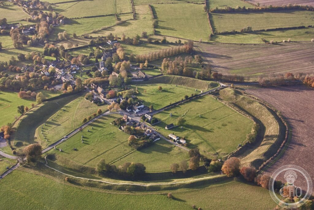
What you see
The henge earthwork, the outer stone circle, and Silbury Hill (the most precisely AveburyEngland single henge bank ditch outer earthwork circuit 1.1 km circumference bank originally 11m high now 5m high ditch outside bank inside bank unusual positioning reversed most henges modern interpretation bank visible outside from afar 4 original causeways entrances henge causeway northeast Kennet Avenue West Kennet Avenue approaches southeast Beckhampton Causeway northwest southeast four causeways entrances outer stone circle 331m diameter 27 of original 98 stones upright natural unworked grey sarsen Marlborough Downs some 40 60 tonnes tall stones 4 5m some fallen Northern Inner Circle originally 29 stones Cove monument inside 3 surviving tall stones most stone circle 2 surviving The Cove Keiller reconstructed 2 stones 1938 CE Southern Inner Circle Obelisk originally 29 stones centre Obelisk removed 1700s CE Ring of Stones 29 stone inner circle nothing survives Keiller Museum Avebury Manor Avebury Great Barn museum Alexander Keiller Museum archaeology museum Avebury National Trust Alexander Keiller Museum outstanding collection Neolithic Bronze Age archaeology Avebury area including skeletons from West Kennet Silbury Hill 2.4 km south visible from henge 37m high 160m base circumference 500m largest prehistoric earthwork hill Europe 4500 years old unknown function not burial 19th century explorers tunnelled inside found no burial chamber Silbury UNESCO heritage: the mystery of Silbury Hill (the largest prehistoric earthwork in Europe with no known purpose): Silbury Hill (ca. 2400 BCE; 37m high; 160m base diameter; approximately 248,000 cubic metres of chalk; constructed in multiple phases over approximately 100 years) is the largest prehistoric earthwork in Europe; its purpose is completely unknown; it is not a burial mound (18 different excavations, including a BBC television excavation in 1969 CE and a major English Heritage investigation in 2007 CE, found no burial chamber and no primary deposit of any kind); proposals include: a symbolic mountain (a man-made sacred hill in a flat landscape), a sun monument (aligned with the midsummer sunrise as seen from the Avebury circles), a fertility symbol (the shape is similar to a pregnant figure), or purely a monument to the labour itself (as a demonstration of social organisation); the 2007 English Heritage investigation found evidence that Silbury Hill is slowly sinking — the chalk fill is settling; the BBC tunnel (1969 CE) has since had to be sealed to prevent collapse)) — the most precisely AveburyEngland single henge bank 1.1 km circumference 5m high originally 11m 4 causeways outer stone circle 331m diameter 27 of 98 upright natural grey sarsen 40 60 tonnes Northern Inner Circle Cove 3 surviving Southern Inner Circle Obelisk removed 1700s nothing survives Keiller Museum National Trust Silbury Hill 2.4 km 37m 160m 248000 cubic metres chalk 4500 years unknown purpose not burial 18 excavations no chamber BBC 1969 English Heritage 2007 settling sinking slowly UNESCO heritage in any UNESCO world heritage site)).
Practical information
- Getting there: from London: train from London Paddington to Swindon (55 min; £25-40 return) then bus to Avebury (Thamesdown Transport X46; 45 min; £5 return; approximately hourly on weekdays; less frequent on weekends and in winter); or rent a car from London (150 km; 2h on the M4/A4 then A361); Avebury is 30 km north of Stonehenge — most visitors combine both on a single day; the Avebury stone circles and henge (free entry; the stone circles are freely accessible 24 hours a day, every day of the year — the village is built inside the monument; you can wander among the standing stones and along the henge earthwork at any time); the Alexander Keiller Museum (£9.50 for National Trust non-members; free for National Trust members; includes the archaeology collection and temporary exhibitions; essential for context); the West Kennet Avenue (free; the 2.5 km stone avenue connecting Avebury to the Sanctuary; 1h walk one way); Silbury Hill (visible from the road; short footpath to the base; do not climb the hill — erosion); West Kennet Long Barrow (free; 1 km south of Silbury Hill; 3700 BCE; you can enter the chambers; a torch (flashlight) is recommended))
Getting there
From London: train to Swindon (55 min £25-40) then bus X46 (45 min £5). Or car M4/A361, 2h. Stone circles: free, open 24 hours (village inside). Alexander Keiller Museum: £9.50. West Kennet Long Barrow: free, 3700 BCE, chambers accessible. Stonehenge 30 km south. GPS: 51.4286, -1.8544.
Nearby
- Stonehenge — 30 km south (UNESCO WHS 1986 (same inscription as Avebury); the most famous prehistoric monument in the world; ca. 3000-1500 BCE; the outer sarsen circle (ca. 2500 BCE; the iconic trilithons — two upright stones topped by a lintel stone; the bluestones (ca. 2500 BCE; transported from the Preseli Hills in Wales, 250 km; the most impressive engineering feat of Neolithic Britain)); the English Heritage visitor centre and timed-entry tickets (essential to book in advance, especially in summer); the Stonehenge Avenue (the 3 km earthwork avenue leading northeast from Stonehenge to the River Avon))
- The Ridgeway — passing 5 km south (the oldest road in Britain; a 135 km Neolithic ridgeway path along the chalk escarpment from Avebury to Ivinghoe Beacon in Hertfordshire; the path passes several Neolithic and Bronze Age monuments including Wayland’s Smithy (a Neolithic chambered tomb; 3700 BCE; an extraordinary chambered tomb in the middle of a beech wood); the Uffington White Horse (3000 BCE; the oldest hill figure in Britain; 110m long; cut into the chalk hillside above the Vale of White Horse))
Sources
- Wikipedia, Avebury; Silbury Hill; West Kennet Long Barrow; Alexander Keiller, accessed June 2026
- UNESCO, Stonehenge, Avebury and Associated Sites, WHS reference 373, inscribed 1986
Find it on the map
See this place and what’s around it →📷 Diventa un fotografo di Cultural Heritage Online
Condividi le tue foto dei luoghi: restano pubblicate con la tua firma come autore. Più vengono viste, più ti fai conoscere — e presto un concorso premierà le foto più apprezzate.
Accedi o registrati gratis per aggiungere una fotoDo you manage this place?
This page is read by travellers and heritage enthusiasts who find it on Google. Keep it accurate — and make it work for you. Free for non-profit heritage institutions.