

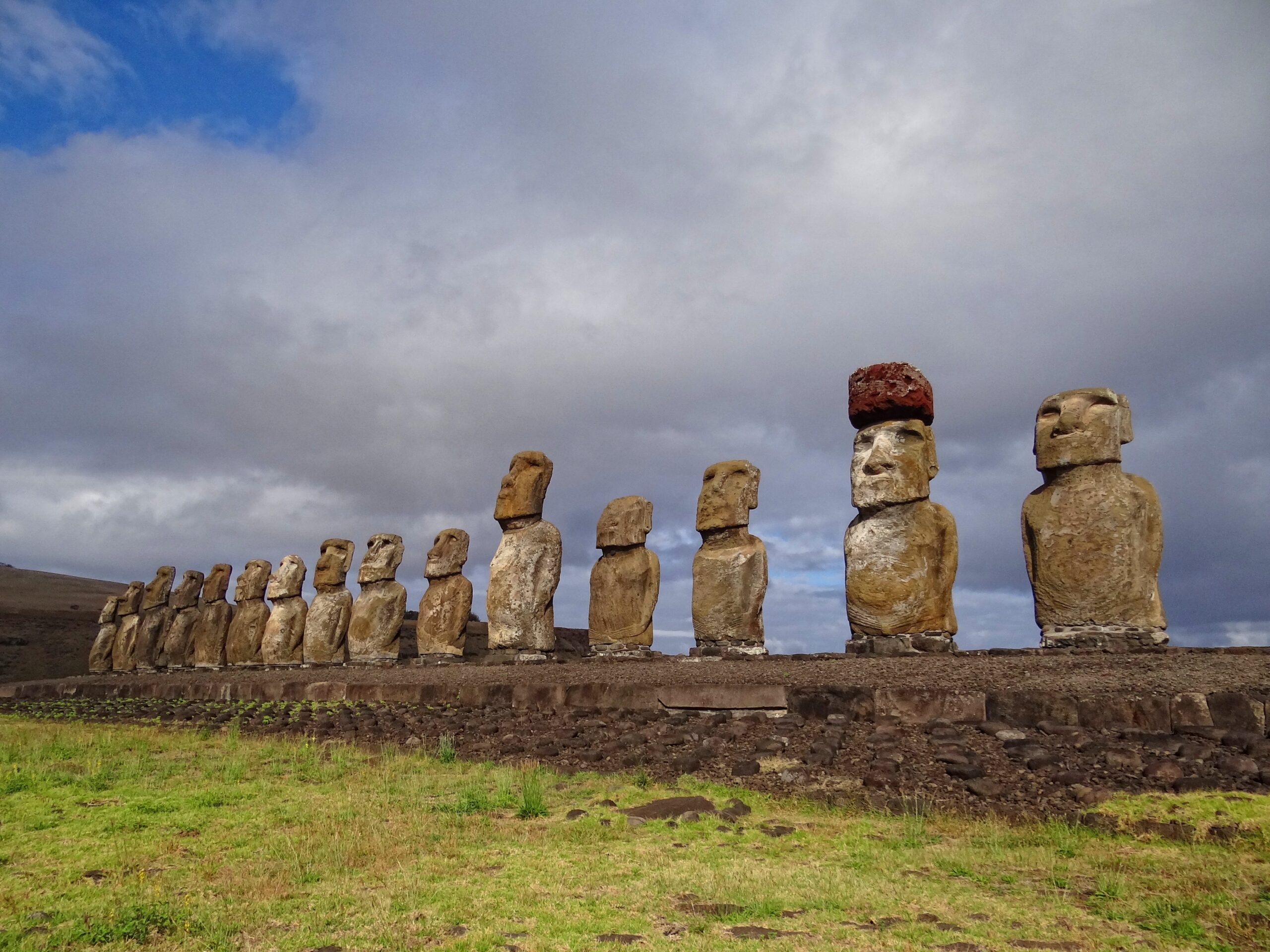
Toppled by rival clans in the 17th century and then hurled inland by a 1960 tsunami, fifteen moai stand again on the largest ceremonial platform on Easter Island — restored over three years by Chilean archaeologists and a Japanese construction company.
At a glance
Ahu Tongariki is the largest ahu (ceremonial stone platform) on Easter Island, a basalt structure 220 metres long on the island’s southeastern coast, facing inland across the Poike volcanic landscape. It carries fifteen moai, ranging from 4 to 9 metres tall and 20 to 90 tonnes in weight; one wears a pukao (red scoria topknot). The moai face inland — as all Easter Island statues do, protecting the community rather than watching the sea. The platform was toppled in the 17th-18th century wars, scattered further by the 1960 Chilean tsunami, and fully restored to its present condition between 1992 and 1995 in one of the largest archaeological reconstruction projects of the 20th century. Together with the sunrise silhouette effect it produces before dawn, Ahu Tongariki is among the most recognised archaeological images in the world.
History
The Rapa Nui people, who reached Easter Island from Eastern Polynesia around 300–900 AD, developed a distinctive monumental culture centred on the carving and erection of moai — ancestor figures representing deceased high-status individuals whose mana (spiritual power) was believed to protect the clan living in front of each ahu. The construction of Ahu Tongariki and the erection of its fifteen moai are estimated to date from approximately 1250–1500 AD, near the peak of Rapa Nui monumental activity.
Between approximately 1600 and 1800, Rapa Nui society experienced a catastrophic breakdown: population growth, resource depletion (primarily the felling of all native palms for canoe-building, rope production, and moai transport), and intensifying competition between clans produced endemic warfare. During this period, rival groups deliberately toppled each other’s moai — the statues were pulled forward, face-down, so they would break at the neck. Every single standing moai on Easter Island was toppled in this period. Ahu Tongariki’s fifteen statues fell, shattering on the basalt platform.
In May 1960, the Great Chilean Earthquake (magnitude 9.5, the most powerful earthquake ever recorded) generated a tsunami that swept across the southeastern coast of Easter Island. The wave reached sufficient height and force to pick up the fifteen shattered moai — some weighing 90 tonnes — and scatter them across more than a kilometre of inland scrubland. The ahu base was also damaged. The site lay as the tsunami had left it for 32 years.
In 1992, Japanese construction company Tadano donated a large crane to the Chilean National Monuments Council to enable restoration. Chilean archaeologist Claudio Cristino led a team working with Tadano’s equipment for three years to locate all scattered fragments, match them to their original moai, and re-erect all fifteen in their pre-toppling positions. The restoration was completed in 1995 and coincided with Rapa Nui’s inclusion in the UNESCO World Heritage Site extension. A single moai from Ahu Tongariki was temporarily loaned to Japan for the 1992 World Expo in Seville (it was returned and re-erected with the others).
What you see
The ahu platform itself is a massive construction: 220 metres long, built from fitted basalt blocks, with a sloped seaward face and a flat landward face against which the moai are set. The fifteen moai stand in a slightly irregular row, their backs to the Pacific Ocean, facing a levelled plaza where clan ceremonies would have been held. The variation in their heights — from 4 to 9 metres — gives the row a dynamic, non-mechanical profile that suggests individual carving rather than production-line uniformity. The largest moai at Ahu Tongariki, the heaviest successfully re-erected moai on Easter Island, weighs approximately 86 tonnes.
One moai at the eastern end of the row wears a pukao — a cylindrical topknot carved from red scoria (volcanic rock from Puna Pau quarry, on the other side of the island), indicating high status. The others are bare-headed. The moai faces show the characteristic Easter Island features: long ears, prominent brows, compressed lips, and the hollow eye sockets that were filled during ceremonies with white coral and red or black pupils. No eye inlays survive in situ.
The setting compounds the effect. The ahu faces inland across the Poike peninsula’s profile; to the east, Rano Raraku — the volcano quarry where all Easter Island moai were carved, 18 kilometres away — is sometimes visible on the horizon. At dawn, with the sun rising behind the statues from the Pacific direction, the moai are silhouetted in a dramatic backlit effect that has made this the most photographed viewpoint on the island. The effect is visible on any clear morning with a sunrise; it is most extreme near the equinoxes.
Key facts
- Location: Southeastern coast of Easter Island, Chile — 27.13°S 109.28°W
- Platform length: 220 metres — the largest ahu on Easter Island
- Number of moai: 15, ranging 4–9 metres tall; heaviest ~86 tonnes
- Original construction: c. 1250–1500 AD (Rapa Nui monumental period)
- Toppled: 17th–18th century inter-clan wars
- Tsunami damage: 1960 Great Chilean Earthquake (M9.5); moai scattered >1 km inland
- Restoration: 1992–1995, led by archaeologist Claudio Cristino; crane donated by Tadano (Japan)
- UNESCO WHS: 1995, as part of Rapa Nui National Park (WHS No. 715)
Historical significance
Ahu Tongariki’s restoration is significant not only as an archaeological achievement but as an act of cultural restitution: the Rapa Nui community had watched the site lie ruined for 32 years, and the decision to restore it was made in consultation with the Rapa Nui people, who regard the moai as embodied ancestors rather than mere monuments. The completed row is now part of living Rapa Nui identity rather than exclusively an object of outside research.
The site also demonstrates the particular vulnerability of Pacific archaeological heritage to natural forces. The 1960 tsunami was a singular event, but rising sea levels, increasingly powerful Pacific storm surges, and erosion are active concerns for all Easter Island ahu. The basalt platforms are not protected from wave action; several ahu on the island’s northern coast show active erosion. Ahu Tongariki’s inland position offers more protection than most.
Practical information
- Entry: Access requires a Rapa Nui National Park entry ticket (approx. USD 80 for foreign nationals, purchased at Hanga Roa or the airport); the ticket covers all park sites for 10 days
- Dawn visit: Arrive 30–45 minutes before official sunrise for the silhouette effect; the site is accessible before the ticket booths open as there is no physical gate
- Distance from Hanga Roa: 18 km east; reachable by rental car, scooter, or guided tour (there is no public transport)
- Time needed: 1–2 hours on site; combine with Rano Raraku quarry (2 km north) in a half-day
- Photography: Tripod advisable for dawn silhouette shots; no drone flights permitted in the National Park without a special permit
Getting there
Easter Island (Isla de Pascua / Rapa Nui) is reached by air from Santiago de Chile (LATAM, approximately 5 hours; daily flights) or Papeete, Tahiti (LATAM, weekly). Mataveri International Airport (IPC) is the only entry point; the single town of Hanga Roa is 1 km from the airport. From Hanga Roa, Ahu Tongariki lies 18 km east via the southern road; scooters (approx. USD 40/day) and cars (USD 70/day) can be rented from several agencies in town.
Nearby
- Rano Raraku (2 km northwest) — the volcanic quarry where all Easter Island moai were carved; approximately 400 statues remain in various stages of completion on the crater slopes — see the CHO profile
- Poike Peninsula (5 km east) — the oldest geological part of the island, with the Poike Ditch (a possible defensive earthwork) and panoramic views of the island’s eastern tip
- Te Pito Kura (8 km northwest) — an ahu site with the largest moai ever transported and erected on an ahu (9.8 metres tall); toppled; also a large round stone said to be the “navel of the world” according to Rapa Nui tradition
Sources
- Ahu Tongariki — Wikipedia
- UNESCO WHS: Rapa Nui National Park
- Easter Island — Wikipedia
- Cristino, C. & Fuentes, M. (2011). The Rapa Nui World. University of Hawaii Press.
- Moai — Wikipedia
Find it on the map
See this place and what’s around it →📷 Become a Cultural Heritage Online photographer
Share your photos of places: they stay published under your name as the author. The more they're seen, the more you get noticed — and soon a contest will reward the most appreciated photos.
Log in or sign up free to add a photo