
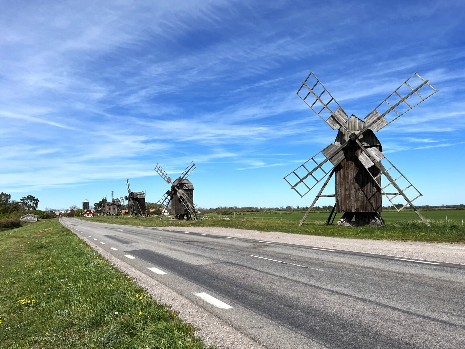
A living 5,000-year archive of human settlement: limestone alvar, windmills, Viking forts, and medieval open fields still farmed today on Sweden’s longest island.
At a glance
The southern half of Öland — Sweden’s second-largest island, stretching 137 km into the Baltic Sea — preserves an unbroken record of how humans have organised land, livestock, and community across five millennia. UNESCO inscribed it a World Heritage Site in 2000, recognising not just individual monuments but an entire landscape still shaped by traditions reaching back to the Neolithic.
At the heart of the site lies Stora Alvaret, one of Europe’s largest limestone plains: a 40-km-long plateau where thin alkaline soils support a remarkable mosaic of rare orchids, migratory birds, and semi-wild grazing cattle. Framing the alvar, a narrow coastal strip holds the island’s villages, burial mounds, ring forts, and over 400 surviving windmills — the densest concentration in Sweden.
Key facts
- UNESCO inscription: 2000 (Cultural Landscape)
- Total area: 56,000+ hectares (southern Öland)
- Stora Alvaret: ~26,000 hectares, Europe’s largest limestone alvar
- Windmills: 400+ surviving; Sweden’s highest concentration
- Human occupation: continuous for at least 5,000 years
- Royal hunting ground: Ottenby estate, southern tip, since 1569 CE
- Location: Island of Öland, Kalmar County, southeast Sweden
- Access: Öland Bridge from Kalmar (mainland) — 6 km, opened 1972
History
Settlement on Öland began in the Neolithic period around 3000 BCE, when the island’s limestone bedrock and coastal fertility attracted farming communities. The Bronze Age (1800–500 BCE) left extensive burial mounds visible across the landscape, concentrated along the coastal strip where the soil supports cultivation. The Iron Age (500 BCE–600 CE) saw the construction of ring-shaped hillforts called borgars — at least 18 survive on southern Öland — along with a wave of runic stones recording the deeds of local chieftains.
Medieval settlement crystallised into the open-field village system that still partly defines the landscape today. Öland’s geology forced a characteristic organisation: each village controlled a strip of coastal farmland, a share of the forest fringe, and access rights to the communal alvar for grazing. This collective management of a limited resource base produced the regular, almost geometric field patterns that are still legible from the air.
The windmill tradition developed from the 17th century onwards, when the island’s persistent Baltic winds made grinding grain by wind far more practical than water mills on the flat island. By the 19th century, Öland had become Sweden’s windmill capital. Most surviving mills are post mills or Dutch-type smock mills, many still privately owned and maintained.
In 1569, King Erik XIV designated the southern tip of Öland — the estate now called Ottenby — a royal hunting preserve. The reserve, which covers the entire southern tip of the island, has been protected in various forms ever since and is now a nature reserve and internationally important bird-ringing station, recording millions of migrants along the Baltic flyway.
What you see
The landscape offers an unusual layering of 5,000 years of human activity without any single dramatic monument dominating. Key elements:
- Stora Alvaret: The great limestone plain — almost entirely flat, largely treeless, with a distinctive flora of orchids (including several rare species), sea lavender, and thyme. Cattle and sheep still graze here under arrangements inherited from medieval commons management. The visual effect — a vast steppe-like expanse in the middle of a Baltic island — is unlike anything else in northern Europe.
- Windmills: Clustered in mill lines (möllrader) along village approaches, the surviving mills range from working restorations to picturesque ruins. Lerkaka, near Mörbylånga, has the island’s most photographed row.
- Iron Age borgars: Ring forts built of dry-stone limestone, typically occupying slight rises with views over the alvar. Gråborg, near Vickleby, is the largest preserved Iron Age fort in Scandinavia.
- Bronze Age burial mounds: Visible across the coastal strip — low turf-covered mounds, often in groups, marking the graves of Bronze Age chiefs and families.
- Runic stones: Scattered through village churches and roadside locations, recording names and deeds in the Viking-age runic alphabet.
- Ottenby: The royal estate at the southern tip, now part nature reserve, part working farm. The Ottenby Bird Observatory here is one of Sweden’s most important ornithological stations.
Practical information
- Open: The landscape is permanently accessible; individual sites have seasonal hours
- Entry: Most sites free; some windmills and manor houses charge admission
- Best time: Late May–early June for alvar orchids; September–October for migrating birds at Ottenby
- Visitor centres: Ottenby Naturum (nature reserve info); Mörbylånga local museum
- Guided tours: Available in summer from the Öland tourist office, Borgholm
- Cycling: Öland is flat and exceptionally cycle-friendly; marked routes connect all major sites
Getting there
Öland is linked to mainland Sweden by the Öland Bridge (6 km, one of the longest bridges in Europe) connecting to Kalmar. Kalmar is 3 hours by train from Stockholm. No rail service on Öland; car or bicycle are the practical options for exploring the southern landscape. The main town is Mörbylånga, near the centre of the inscribed area. Borgholm, in the north of the island, is the main tourist hub and ferry terminal for seasonal connections.
Nearby
Kalmar Castle (mainland, 15 km across the bridge) is one of Sweden’s best-preserved Renaissance castles. The island of Gotland, 90 km to the east across the Baltic, is another UNESCO World Heritage Site (the medieval town of Visby). Southern Öland’s neighbouring landscape transitions seamlessly into the cultural reserve — the entire island can be explored as a single cultural itinerary over 2–3 days.
Sources
- UNESCO World Heritage Centre: Agricultural Landscape of Southern Öland (whc.unesco.org, ref. 968)
- Wikipedia: Agricultural landscape of southern Öland (en.wikipedia.org)
- Swedish National Heritage Board (Riksantikvarieämbetet): Öland landscape documentation
- Öland Tourist Office: visitor information and cycling routes
Find it on the map
See this place and what’s around it →📷 Become a Cultural Heritage Online photographer
Share your photos of places: they stay published under your name as the author. The more they're seen, the more you get noticed — and soon a contest will reward the most appreciated photos.
Log in or sign up free to add a photo