Pentedattilo Village
A dramatically perched clifftop village whose five rocky peaks resemble a giant hand, Pentedattilo rises 250 metres above the Vallata Sant’Elia valley in southern Calabria.
At a glance
Pentedattilo commands the landscape from atop Monte Calvario, its distinctive silhouette defined by five towering sandstone formations. The village overlooks a valley of remarkable geological features, including the sandstone fortresses of Santa Lena and Prasterà, along with an ecosystem of olive trees, prickly pears, broom, and seasonal almond and mimosa blooms. Historic water mills with Greek-style wheels once dotted the area, powered by the Sant’Elia river and vital to the valley’s medieval economy.
History
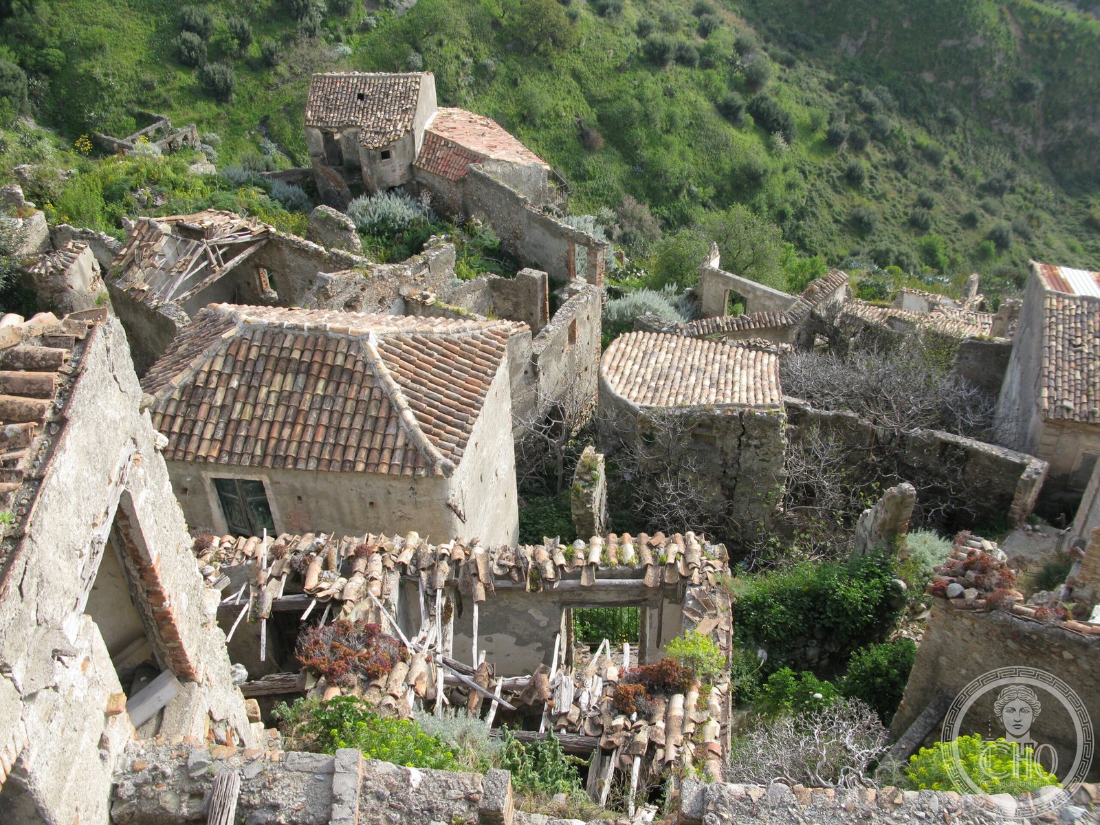
Pentedattilo was completely abandoned by the mid-1960s, emptied as modern life drew residents away. The village remained largely deserted until the early 1980s, when young people and cultural associations rediscovered its potential. What followed was a gradual recovery led by European volunteers, transforming the abandoned settlement into a living monument to rural resilience and collective memory.
What you see
The village’s most striking feature is the majestic sandstone cliff formation above it—five distinct peaks that give Pentedattilo its name, evoking an ancient hand reaching skyward. The narrow streets and stone structures preserve the character of a traditional Calabrese settlement. The surrounding valley reveals traces of the old milling infrastructure that once sustained the community, alongside the dramatic natural fortresses of Santa Lena and Prasterà.
Cultural significance
Pentedattilo represents both geological spectacle and human perseverance. The village embodies a critical moment in twentieth-century rural history—abandonment and rediscovery—while the valley’s landscape documents centuries of adaptation to Mediterranean geography. Its recovery by international volunteers reflects growing recognition of vernacular heritage and the importance of preserving communities that might otherwise vanish from memory.
Key facts
- Location: 89063 Melito di Porto Salvo, Calabria
- Elevation: 250 metres above sea level
- Coordinates: 37.95412988765772, 15.761046409606934
- Website: calabriagreca.it
Practical information
Opening hours and admission fees are not listed; check the official website or contact local visitor information in advance. The village terrain is steep and involves walking on uneven paths.
Getting there
Pentedattilo is located in Melito di Porto Salvo in the Reggio Calabria province. You can access the village from the Ionian coast road; local signage directs visitors to the village entrance. Public transport options are limited; a car is recommended for independent travel in this region.
Sources & resources
Find it on the map
See this place and what’s around it →📷 Diventa un fotografo di Cultural Heritage Online
Condividi le tue foto dei luoghi: restano pubblicate con la tua firma come autore. Più vengono viste, più ti fai conoscere — e presto un concorso premierà le foto più apprezzate.
Accedi o registrati gratis per aggiungere una foto