
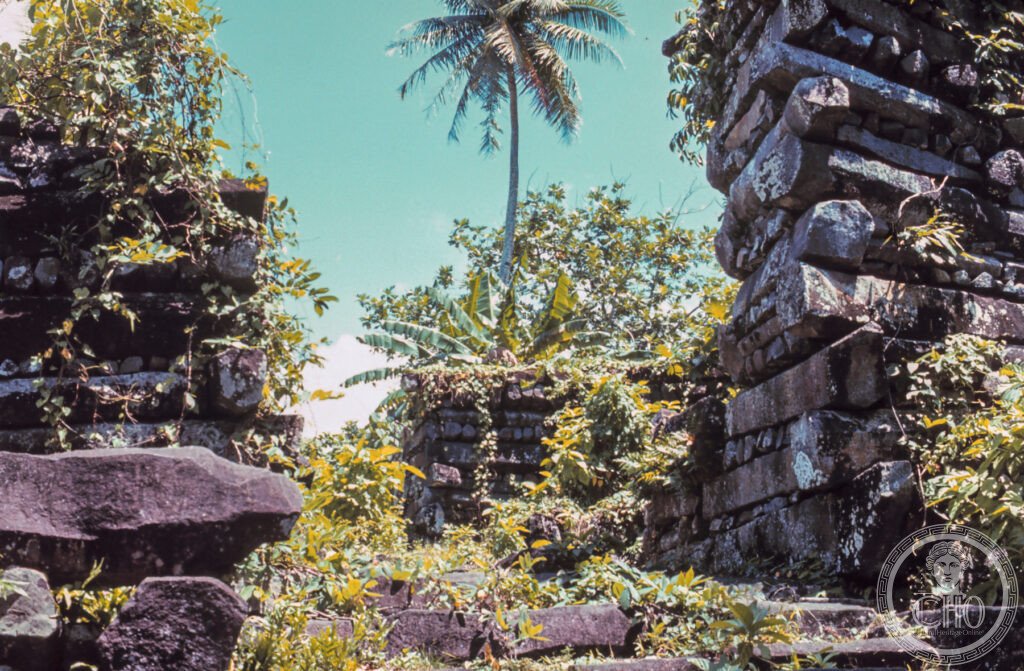
Ninety-two artificial islets of stacked basalt columns rise from a coral reef off Pohnpei, the abandoned capital of a dynasty of god-kings who ruled for nine centuries from a city with no fresh water and no soil. How its fifty-tonne stones were moved from a quarry across the island has never been explained.
At a glance
Nan Madol sits on the tidal flats beside Temwen Island, off the eastern coast of Pohnpei. Its name is thought to mean “spaces between things” in Pohnpeian, a reference to the tidal channels running between the islets. The city was built by stacking prismatic columns of basalt, the same naturally hexagonal rock formed by cooling lava that appears at the Giant’s Causeway in Northern Ireland, in crisscross log-cabin courses to raise walls several metres high.
It was the seat of the Saudeleur dynasty, sacred rulers who governed Pohnpei from this offshore capital, physically separated from the commoners on the main island. The arrangement kept the god-kings unseen and made them very difficult to reach, a design that was as political as it was symbolic.
Key facts
- Location: Pohnpei Island, Federated States of Micronesia, on the reef flats beside Temwen Island.
- Construction: begun around 700 CE and enlarged continuously until the dynasty’s fall around 1628 CE.
- Layout: 92 man-made islets separated by tidal canals, divided into a ceremonial-mortuary district and an administrative district.
- Material: columnar basalt quarried elsewhere on Pohnpei; the largest blocks are said to weigh around 50 tonnes, and how they were transported to the site remains unresolved.
- Heritage status: inscribed by UNESCO in 2016 and placed on the World Heritage in Danger list at the same time.
History
Radiocarbon evidence points to construction beginning around 700 CE. The site had no fresh water and could support no agriculture, so drinking water and food were brought in by canoe from the main island as tribute. Over roughly nine centuries the ruling class expanded the complex to its 92 islets, while the surrounding commoner population lived on Pohnpei itself.
The Saudeleur dynasty was overthrown by the warrior Isokelekel, who is said to have led an invasion fleet from Kosrae around 1628 CE. The new system of governance that followed, a confederation of chiefs rather than a single god-king, had no need of an isolated royal capital. Nan Madol was abandoned within a generation and the jungle and mangroves began to reclaim it. By the time a Spanish expedition reached Pohnpei in 1595, and later German, American and Japanese administrations surveyed the island, the city was already a ruin.
What you see
The 92 islets are threaded together by a network of canals navigable by shallow-draft canoe, tidal water flowing through them and rising and falling twice a day. Exploration is by boat, ideally at low tide, when the basalt walls stand clear of the water.
The complex divides into two districts. Madol Powe, on the ocean side, held the ceremonial and mortuary buildings, including the royal mortuary compound of Nandauwas, the priests’ houses and sacred eel pools, and is considered the most sacred part of the site. Madol Pah, on the lagoon side, was the administrative and food-preparation district, with islets given over to canoe storage and cooking.
Practical information
- Access: the site is reached by boat through mangrove channels, and a local guide is required under Pohnpei State regulation; guides are familiar with the site’s protocol and the areas considered kapu, or forbidden, by local tradition.
- Best time to visit: low tide, when the canals are more passable and the basalt walls are fully exposed.
- Duration: visitors should allow a generous stretch of the day to see the main islets properly.
- Further context: the Pohnpei Cultural Center in Kolonia has exhibits on Nan Madol and the Saudeleur dynasty.
Getting there
Pohnpei is reached by air via Guam. From Kolonia, the state capital, the site involves a short drive followed by a boat crossing through the mangroves; current schedules and guide arrangements are best checked with the airline and local tourism office directly.
Nearby
- Kepirohi Waterfall — around 10 km from Kolonia, Pohnpei’s most accessible waterfall, with a natural pool at its base considered sacred in local tradition.
- Sokehs Rock — around 5 km north of Kolonia, a sheer basalt cliff above the lagoon and the site of the Sokehs Rebellion of 1910–1911, when Pohnpeian warriors under Soumadau en Sokehs resisted German colonial rule.
Sources
- Wikipedia, Nan Madol
- Wikipedia, Saudeleur dynasty
- Wikipedia, Isokelekel
- UNESCO, Nan Madol: Ceremonial Centre of Eastern Micronesia, WHS reference 1503
Find it on the map
See this place and what’s around it →📷 Become a Cultural Heritage Online photographer
Share your photos of places: they stay published under your name as the author. The more they're seen, the more you get noticed — and soon a contest will reward the most appreciated photos.
Log in or sign up free to add a photo