Anjar
The only surviving city entirely conceived and built during the Umayyad Caliphate — Anjar (ancient Chalcis ad Belum), established around 714 AD by Caliph Walid I in the Bekaa Valley of modern Lebanon, is the best-preserved urban plan of the Umayyad period: a strict Roman-derived grid of approximately 370 × 310 metres with 600 shops, two palaces, a mosque, and bath complexes arranged on a regular street plan that reveals the Umayyad Caliphate’s deliberate adoption of Roman urban administrative forms.
At a glance
Anjar lies in the Bekaa Valley of Lebanon, 58 km east of Beirut (1h by car) and 10 km south of Chtaura (the main commercial junction of the valley). The ruins cover approximately 11.5 hectares within the original city walls; they are open to visitors as an archaeological site managed by the Lebanese Department of Antiquities. The site is not large (the full circuit of the walls and the principal ruins can be walked in 1.5–2 hours) but is of exceptional historical importance as the only intact Umayyad planned city; it is most often combined with a visit to the Roman temple complex at Baalbek (65 km north of Anjar, in the same Bekaa Valley) and the wine estates of the Bekaa (Château Ksara, Château Kefraya, and Château Musar are all within 30 km).
Key facts
- The Umayyad Caliphate and the founding of Anjar (c. 714–715 AD): the only city-scale project executed entirely under a single Umayyad caliph — the Umayyad Caliphate (661–750 AD) was the first great Islamic caliphate, ruling from Damascus over a territory extending from Spain to Central Asia; its caliphs were notable builders (the Dome of the Rock in Jerusalem, 691; the Great Mosque of Damascus, 705–715; the desert palaces of Jordan and Syria); Caliph Walid I (al-Walid ibn Abd al-Malik, r. 705–715) founded the city of Anjar (his documents call it “’Ayn al-Jarr”, the spring of the Jarr) as a planned commercial and administrative city in the Bekaa Valley, probably to control the trade routes between Damascus (60 km south-east) and the Mediterranean ports; the city was built in approximately 10 years (c. 705–715 AD); Walid I died in 715 AD and his successors do not appear to have continued the city’s development
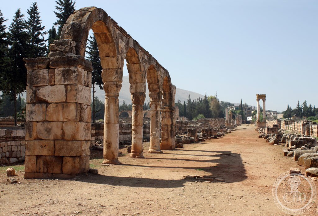
- The Roman grid plan: the most explicit Umayyad adoption of Roman urban planning in the surviving record — Anjar is built on a strict orthogonal grid derived from the Roman castrametation (military camp layout) and the Roman provincial city plan: a central north-south street (cardo maximus) and a central east-west street (decumanus maximus) divide the city into four equal quadrants; where they cross, a tetrapylon (four-columned arch) marks the intersection; 600 shops (dukkan) line the main streets in continuous arcades (the colonnaded street); the north-east quadrant contains the Great Palace (the caliph’s representative residence); the north-west quadrant contains the Small Palace (the administrative centre and the governor’s residence); the south-east quadrant contains the Great Mosque; the south-west quadrant has the bath complex and residential areas; the city walls (approximately 370 × 310 metres; 4 gates with projecting towers; approximately 40 wall towers) are derived from late Roman fortification design; the combination of Roman urban form with Islamic programme (mosque, bazaar, caliphal palace) makes Anjar the clearest surviving record of Umayyad architectural synthesis
- The carved stone decoration: the finest surviving Umayyad secular stone carving in Lebanon — the Great Palace at Anjar (the caliph’s formal reception building in the north-east quadrant) preserves significant stone carving in its arcade columns and spandrels; the capitals are a hybrid form combining Byzantine Corinthian capitals (with acanthus leaves) with Umayyad-style interlaced vine scroll decoration; the arch spandrels have carved arabesques in a style closely related to the carved stucco decoration of the Umayyad desert palaces of Jordan (Khirbat al-Mafjar, Qasr ‘Amra); the carved stone panels of the Great Palace are the most important surviving examples of Umayyad secular architectural sculpture in the Levant; stone was used rather than brick (as in the Mesopotamian architectural tradition) because the Bekaa Valley has abundant quarries of good limestone
- The abandonment (750 AD) and the Armenian community: the city was abandoned when the Umayyad Caliphate was overthrown — the Abbasid Revolution (750 AD) overthrew the Umayyad Caliphate and established a new dynasty based in Baghdad; the Abbasids had no interest in maintaining the Umayyad capital’s administrative infrastructure in Syria and Lebanon; Anjar was abandoned almost immediately after 750 AD and the ruins were covered by soil and vegetation; the village of Anjar, founded adjacent to the ruins, was established in 1939 as the settlement of approximately 1,500 Armenian refugees (survivors of the 1915–1920 Armenian Genocide) resettled in Lebanon by the French Mandate authorities; the Armenian community of Anjar has maintained the village and the archaeological site for over 80 years; the village has a strong Armenian cultural identity (Armenian language, school, and church) that coexists with the Umayyad archaeological site
- Heritage: UNESCO World Heritage Site, Anjar, inscribed 1984 (part of a group of five Lebanese UNESCO WHS including Baalbek, Byblos, Tyre, and the Qadisha Valley)
- GPS: 33.7311° N, 35.9189° E
History
The site was the location of the ancient city of Chalcis ad Belum (a Hellenistic and Roman city of the Bekaa; minor importance in the ancient record); Caliph Walid I founded the Umayyad city approximately 714–715 AD; the city functioned as an administrative and commercial centre for approximately 35 years (714–750 AD); the Abbasid Revolution abandoned the city in 750 AD; the ruins were covered by soil and vegetation and were not recognized as a major archaeological site until the French Mandate period (the archaeologist Maurice Chéhab began systematic excavations in 1949 and identified the Umayyad plan); the adjacent Armenian village was founded 1939; UNESCO inscription 1984; excavations continue (Lebanese Department of Antiquities, University of Bern).
What you see
Enter the site from the south gate; walk north on the main cardo maximus to the tetrapylon at the centre; from the tetrapylon, the Great Palace compound is visible to the right (north-east); the most impressive surviving structure is the arcade of the Great Palace (rows of columns with Umayyad-Byzantine hybrid capitals supporting arches; a 20-metre section of arcade has been re-erected from fallen columns and gives the best sense of the original colonnaded street character); in the north-east quadrant, the Great Palace reception hall is identifiable from the floor plan (the column bases of the apse end are intact); the city walls (best preserved on the south and east sides) can be walked along the exterior; the Small Palace in the north-west quadrant has a more compact surviving plan and is the best-preserved building complex at the site; the bath complex (in the south-west quadrant) is identifiable from its underfloor hypocaust heating system.
Practical information
- Admission: approximately 6,000 Lebanese Pounds (the price changes rapidly with the Lebanese currency crisis; check current admission at the site; approximately €2–5); open daily 9am–6pm; a local guide (available at the site entrance) adds significantly to the experience; the site has a small visitor centre with an explanatory model of the city plan; the Armenian village of Anjar adjacent to the site has several restaurants serving Lebanese-Armenian cuisine (the Armenian community’s food tradition includes dishes specific to the Eastern Anatolian Armenian heritage not found elsewhere in Lebanon); visiting the village gives additional cultural context
- Getting there: from Beirut: 58 km east via the Beirut–Damascus motorway (E0001) to the Chtaura junction, then south on the Bekaa motorway (approximately 1h by car); no public transport serves Anjar directly; the most practical approach is by service taxi from Chtaura (on the main Beirut–Damascus road); alternatively, hire a private car or join a tour from Beirut that combines Anjar with Baalbek (the combination of an Umayyad city of the 8th century with a Roman temple complex of the 1st–3rd centuries is historically logical and physically convenient — both are in the Bekaa Valley)
- The Bekaa Valley circuit: Anjar is best visited as part of a Bekaa Valley day from Beirut combining: Anjar (the Umayyad city, 1–2 hours), Baalbek (the Roman temple complex; 65 km north of Anjar; the largest surviving Roman temple complex in the world; UNESCO WHS 1984; the Temple of Jupiter Heliopolitanus is the largest Roman temple ever built, 70 × 55 metres of podium; the Temple of Bacchus is the best-preserved major Roman temple in the world), and one of the Bekaa wine estates (Château Ksara, founded 1857; Château Kefraya; or Château Musar, producing what Wine Spectator has called “the most exciting wine in the world”, the Château Musar red, a blend of Cabernet Sauvignon, Cinsault, and Carignan from the Bekaa)
Getting there
From Beirut by car (58 km, 1h via E0001). Service taxi from Chtaura junction. No direct public transport. GPS: 33.7311, 35.9189.
Nearby
- Baalbek — 65 km north of Anjar (1h by car); the largest and most spectacular Roman temple complex in the world and the supreme monument of Roman religious architecture in the ancient Near East — the Baalbek sanctuary (ancient Heliopolis; “City of the Sun”) was built on a Phoenician sacred site associated with Baal; the Romans built a sequence of temples dedicated to Jupiter, Bacchus, and Venus beginning in the 1st century BC; the Temple of Jupiter Heliopolitanus (the largest Roman temple ever built, with a podium 88 × 48 metres and columns 21.4 metres tall — the tallest Roman columns in existence; only 6 of the original 54 standing columns survive) dominates the site; the Temple of Bacchus (2nd century AD; 66 × 35 metres; the best-preserved major Roman temple in the world; the interior ceiling of the porch, with its extraordinary carved stone vault and Dionysiac mythological reliefs, is the finest Roman architectural sculpture in the Near East) is the essential interior visit; UNESCO WHS 1984; see separate CHO place card
- Byblos (Jbeil) — 80 km north-west of Anjar (1h 20 min by car); one of the oldest continuously inhabited cities in the world and the origin of the alphabet — Byblos (Jbeil in Arabic; Gebal in the Bible) has been continuously inhabited for at least 7,000 years (Neolithic remains from c. 5000 BC) and was the most important Phoenician city of the 3rd–2nd millennia BC; it gave its name to the Greek word for book (biblion), which gave the Bible its name; the Phoenician alphabet (the ancestor of the Greek, Latin, Hebrew, and Arabic alphabets and ultimately of all modern alphabets of the world) was first attested in inscriptions from Byblos in the 11th century BC; the archaeological site (covering Neolithic, Bronze Age, Phoenician, Hellenistic, Roman, Crusader, and Ottoman layers) is one of the most historically dense in the world; the Crusader Castle (12th century AD; built with stones from earlier monuments) gives panoramic views over the ancient harbour and the modern city; UNESCO WHS 1984; see separate CHO place card
- Beirut’s Downtown Archaeological Zone — 58 km west of Anjar (1h by car); the most urban and layered archaeological site in Lebanon — the rebuilding of central Beirut after the Lebanese Civil War (1975–1990) revealed an extraordinary sequence of archaeological layers beneath the modern city: the Phoenician port city, the Hellenistic city of Berytus, the Roman colony (the most important Roman law school in the ancient world was at Berytus; it trained the jurists who compiled the Justinian Code), the Byzantine city, and the medieval Crusader city are all stratified below the modern streets; the principal archaeological remnant visible today is the Tell (mound) in the Place de l’Étoile, which preserves the Roman forum; the Beirut National Museum (the most important collection of Lebanese antiquities) has recently completed a major renovation of its archaeological and numismatic collections (the collection includes gold and silver Phoenician jewellery, Bronze Age sarcophagi, Roman mosaics, and Crusader inscriptions)
Sources
- Wikipedia, Anjar, Lebanon; Umayyad architecture; Walid I, accessed June 2026
- UNESCO, Anjar, WHS reference 293, inscribed 1984
- Katharina Otto-Dorn, Das islamische Iznik, De Gruyter, 1941 (Umayyad architectural context)
- Robert Hillenbrand, Islamic Architecture, Columbia University Press, 1994 (Anjar and Umayyad planning pp. 395–412)
Find it on the map
See this place and what’s around it →📷 Diventa un fotografo di Cultural Heritage Online
Condividi le tue foto dei luoghi: restano pubblicate con la tua firma come autore. Più vengono viste, più ti fai conoscere — e presto un concorso premierà le foto più apprezzate.
Accedi o registrati gratis per aggiungere una foto