Chaine des Puys — Limagne Fault Tectonic Arena
A chain of 80 dormant volcanoes rising in perfect alignment above the Limagne plain near Clermont-Ferrand, France — one of the best-preserved examples of continental rift and intraplate volcanism on Earth. UNESCO World Heritage Site since 2018.
At a glance
The Chaine des Puys is a north-south alignment of 80 young volcanic peaks stretching 40 kilometres through the Massif Central of France, just west of Clermont-Ferrand in the Auvergne region. The chain sits atop one of the most significant geological features in Western Europe: the Limagne Fault, a major Cenozoic rift that has been subsiding for 35 million years while the volcanic chain above it erupted in geologically recent times.
Together — volcanic chain plus rift fault — they form what geologists call a tectonic arena: a place where the mechanics of crustal extension and intraplate volcanism are visible at the surface in extraordinary clarity. The youngest eruptions ended approximately 6,600 years ago; the volcanoes are dormant, not extinct.
Key facts
- UNESCO designation: World Heritage Site, 2018 (natural property)
- Number of volcanic peaks: 80, forming a 40 km north-south chain
- Age range: oldest c. 95,000 years; youngest eruption c. 6,600 BCE
- Highest peak: Puy de Dome, 1,465 m (lava dome)
- Geological context: Limagne Fault rift zone, part of the European Cenozoic Rift System
- Volcanic forms: lava domes, cinder cones, maars, lava flows
- Notable lava flow: Cheire d’Aydat — 8,500-year-old flow from Puy de la Vache, still topographically intact
- Historical landmark: Puy de Dome summit — site of Blaise Pascal’s 1648 barometric pressure experiment
History
Geologically, the Chaine des Puys chain began erupting around 95,000 years ago as the Limagne Fault continued its long subsidence. The most recent volcanic episode, ending around 6,600 BCE, produced some of the best-preserved landforms in the chain — including the Puy de la Vache and its Cheire d’Aydat lava flow, which buried a Neolithic valley and remains essentially unvegetated today.
Human history at the site stretches back to at least the Neolithic. The summit of the Puy de Dome (the highest peak at 1,465 m) held a Gaulish sanctuary to the god Lugh, later converted into a prominent Roman temple of Mercury — one of the most important Roman temples in Gaul, its foundations excavated in the 19th century and preserved on the summit. A medieval chapel succeeded the Roman temple through the Middle Ages.
The most famous episode in the mountain’s cultural history took place on 19 September 1648, when Florin Perier — brother-in-law of Blaise Pascal — carried a mercury barometer to the Puy de Dome summit on Pascal’s instructions. The mercury column fell 8.5 cm with the gain in altitude, definitively proving that atmospheric pressure decreases with height. Pascal’s experiment, conducted here, was a foundational moment in the history of physics, directly challenging the Aristotelian claim that nature abhors a vacuum.
Volcanological science was born partly in Auvergne. Nicolas Desmarest’s 1763-1771 field mapping of the chain established that basalt columns here were of volcanic origin — settling a pan-European scientific controversy that had simmered for decades and launching the discipline of historical geology.
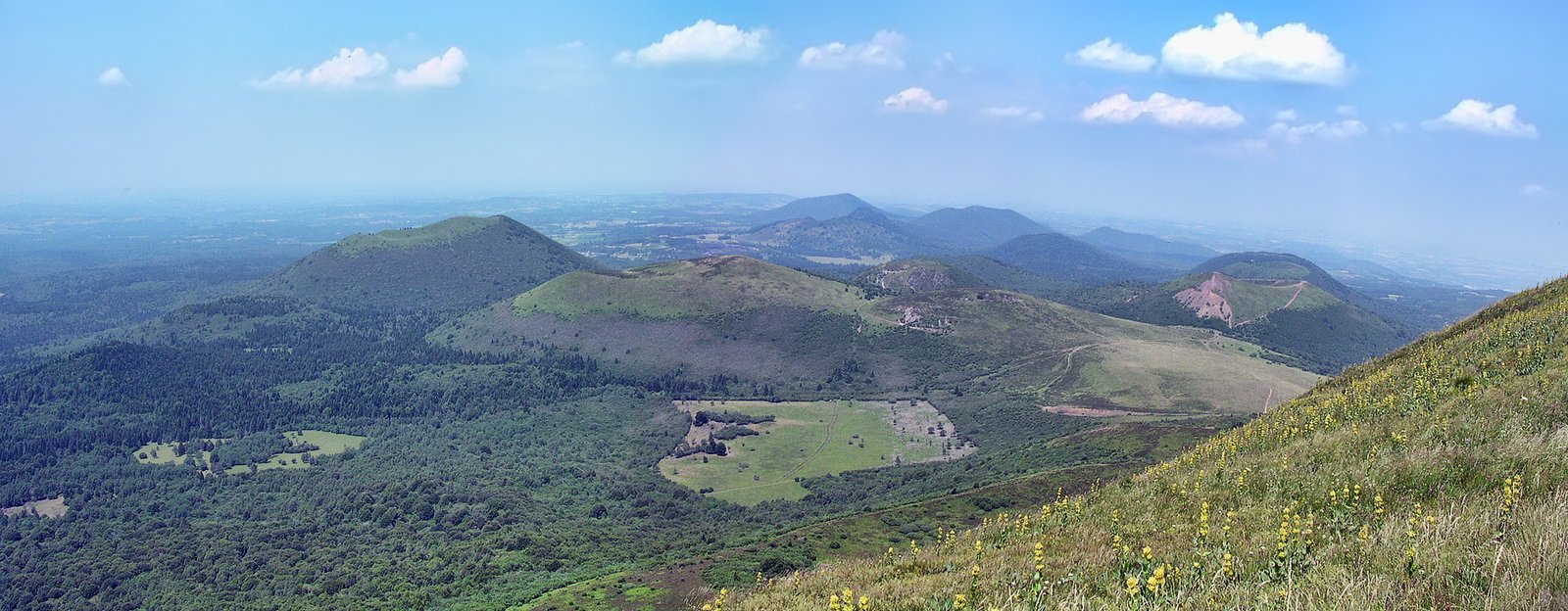
What you see
The chain presents a textbook catalogue of volcanic landforms. Lava domes: Puy de Dome is the largest — its swollen summit rising 400 m above the surrounding plateau in a rounded mass of trachyte lava that never fully erupted explosively. Cinder cones: Puy de Pariou is a near-perfect cone with a sharply defined crater bowl; Puy de Come retains a double-crater rim. Maars (explosion craters filled by lakes): the Gour de Tazenat in the northern chain is a circular lake occupying a maar throat. Lava flows: the Cheire d’Aydat — a broad tongue of black jagged basalt stretching 15 km from Puy de la Vache — is the most dramatic, still largely bare of vegetation millennia after solidification.
On the Puy de Dome summit: the foundations of the Roman Mercury temple, a restored 1876 meteorological observatory (the oldest high-altitude observatory in France still in operation), and the Panoramique des Domes rack railway that has served visitors since 1926. On clear days the view encompasses the entire chain and the Limagne plain.
Practical information
- Puy de Dome access: Panoramique des Domes rack railway (ticketed, year-round with seasonal reductions) or the Chemin des Muletiers hiking trail (free, approx. 2.5 h return)
- Visitor centre: Vulcania — European Park of Volcanism — near Saint-Ours-les-Roches (admission fee; all ages)
- Base town: Clermont-Ferrand (pop. ~150,000), 15 km east of the chain
- Long-distance hiking: GR441 trail circuits the entire chain (approx. 120 km over several days)
- Best months: May to October; summit often cloudy in winter; snow possible from November
- Nearest airport: Clermont-Ferrand Auvergne Airport (CFE)
Getting there
Clermont-Ferrand is served by the A71 motorway (Paris 400 km; Lyon 170 km) and by direct intercity rail from Paris Gare de Lyon (approximately 3 hours). The rack railway base station is at Col de Ceyssat on the D941b; seasonal local buses run from Clermont-Ferrand city centre. For the broader chain, a car or bicycle is the most practical option — the plateau roads are well signposted for cycling.
Nearby
- Clermont-Ferrand — medieval cathedral built from black Volvic volcanic stone; lively old town; Michelin museum
- Orcival Basilica — 12th-century Romanesque pilgrimage church on the Auvergne Romanesque Route, 20 km west
- Issoire — finest Romanesque church in Auvergne (Saint-Austremoine), 35 km south
- Vichy — Belle Epoque spa resort and thermal town with Art Deco architecture, 60 km north
- Lac de Guery — high plateau lake at 1,244 m surrounded by volcanic meadows, 15 km from Puy de Dome
Sources
- UNESCO World Heritage Centre — Chaine des Puys – Limagne Fault Tectonic Arena (whc.unesco.org/en/list/1510)
- Nehlig, Pierre et al. — Volcanisme et geodynamique en Auvergne, BRGM Editions (2003)
- Pascal, Blaise — Recit de la grande experience de l’equilibre des liqueurs (1648) — original account of the Puy de Dome experiment
- Wikipedia contributors — “Chaine des Puys” (en.wikipedia.org)
- Parc Naturel Regional des Volcans d’Auvergne — official documentation
Find it on the map
See this place and what’s around it →📷 Diventa un fotografo di Cultural Heritage Online
Condividi le tue foto dei luoghi: restano pubblicate con la tua firma come autore. Più vengono viste, più ti fai conoscere — e presto un concorso premierà le foto più apprezzate.
Accedi o registrati gratis per aggiungere una foto