
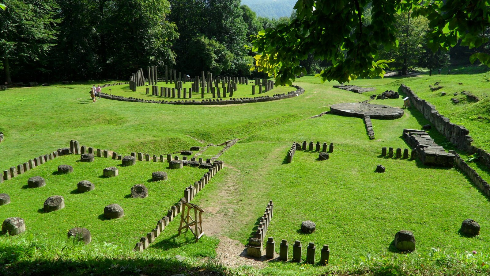
The political, military, and religious capital of the Dacian kingdom, systematically destroyed by the Roman Emperor Trajan in 106 AD and now one of the most dramatic and least-visited ancient capitals in Europe, concealed in dense Transylvanian forest at 1,200 metres elevation.
At a glance
Sarmizegetusa Regia crowns a forested spur of the Sureanu Mountains in the Orăștie range of central Romania, roughly 30 km from the modern town of Orăștia. Founded around 50 BC as a combined hilltop fortress, aristocratic settlement, and sacred precinct, it grew into the largest pre-Roman settlement in Transylvania under the Dacian king Decebalus. Its destruction by Trajan’s legions in 105–106 AD was thorough and deliberate — the Romans needed to erase the Dacians’ symbolic and religious centre — yet the stone foundations of the sacred area survive with remarkable clarity, including the unique circular sanctuary sometimes called the “Romanian Stonehenge.” The site has been a UNESCO World Heritage Site since 1999 as part of the Dacian Fortresses of the Orăștie Mountains.
Key facts
- Founded: c. 50 BC; peak under Decebalus c. 87–106 AD
- Destroyed: 106 AD by Emperor Trajan following two Dacian Wars (101–102, 105–106)
- Elevation: approximately 1,200 metres in the Sureanu Mountains
- UNESCO WHS: 1999 — part of Dacian Fortresses of the Orăștie Mountains (component VI)
- Key feature: Circular sanctuary of andesite pillars — interpreted as a solar calendar or astronomical observatory
- Primary visual record: Trajan’s Column in Rome, 155 narrative scenes of the Dacian Wars
- Access: Forest track from Grădiștea de Munte; no public transport; 4WD advisable in wet conditions
History
The Dacians — a Thracian people who dominated the Carpathian basin from roughly the 1st century BC — chose the ridge above modern Grădiștea de Munte for their capital for reasons of defence and sanctity simultaneously. By the time of King Burebista (c. 82–44 BC), who briefly united Dacian tribes into a major power that alarmed Julius Caesar, the site had already assumed political importance. Under Decebalus it became the undisputed centre of the Dacian state: a grid of terraces cut into the hillside supported rectangular buildings interpreted as aristocratic residences, craft workshops, and storehouses, while the outer ring of stone walls with square towers enclosed an area large enough to sustain a substantial permanent population.
Decebalus’s success in defeating Roman forces in the 80s and 90s AD — forcing Emperor Domitian to pay tribute in 89 AD — made Trajan’s subsequent campaigns (101–102 and 105–106 AD) campaigns of personal prestige as much as strategic necessity. After the second campaign Trajan garrisoned Dacian territory as the new province of Dacia and founded a new Roman city, Colonia Ulpia Traiana Augusta Dacica Sarmizegetusa, in the plain below — deliberately using a version of the original name to assert continuity and legitimacy. The original hilltop capital was left to ruin. Its systematic demolition means that little above foundation level survives, but the foundations themselves are extraordinarily complete.
Rediscovery was gradual: Romanian scholars began investigating the site in the 19th century, and systematic excavation began in the 1950s. A major ongoing problem is illegal metal-detector looting; the UNESCO designation and increased enforcement have helped, though the remoteness of the site makes policing difficult.
What you see today
The Sacred Area on the highest terrace is the most striking part of the site. Two large rectangular temples — their limestone floor slabs and andesite threshold blocks still in place — flank the circular sanctuary, which consists of a ring of tall andesite pillars surrounding a smaller inner arrangement and a central wooden post. The geometry of the outer ring — its circumference, the spacing of the pillars, and orientation — has generated debate about whether it served primarily as a temple, a calendar for agricultural scheduling, or an astronomical observation device.
Below the Sacred Area, the terraced residential and workshop zones are visible as broad earthen platforms cut into the hillside, with occasional stone foundations at ground level. The outer defensive wall, built of large square-cut stone blocks in the murus dacicus technique (stone face, earth and timber fill), survives in several sections to appreciable height. A small site museum near the car park at the base of the access track displays finds and interpretive material; the main collections are held at the Dacian Museum in Deva.
Practical information
- Opening: Site open year-round; best visited May–October; access road may be impassable in winter
- Entry: Small admission fee payable at site
- Duration: Allow 2–3 hours for the full circuit of the terraces and sacred precinct
- Footwear: Hiking boots essential — steep uphill climb on forest track from car park
- Facilities: Very limited — bring water and food; nearest services in Orăștia (30 km)
Getting there
The site is reached via Grădiștea de Munte village in Hunedoara County, approximately 30 km south of Orăștia. There is no public transport to the site; visitors must arrive by private car or guided tour. The access road from Grădiștea de Munte is unpaved and approximately 7 km long — passable by ordinary car in dry summer conditions but requiring a high-clearance vehicle after rain. From the car park, the walk to the Sacred Area takes 20–30 minutes on a marked forest path. Nearest railway station: Orăștia, on the Bucharest–Timișoara main line.
Nearby
- Blidaru Fortress (18 km) — another UNESCO Dacian Fortresses component, best-preserved murus dacicus walls in Romania
- Colonia Ulpia Traiana Sarmizegetusa (35 km) — Roman successor capital founded by Trajan; forum, amphitheatre, and temples
- Deva Citadel (45 km) — medieval fortress on a volcanic plug; Dacian Museum in town
- Corvin Castle, Hunedoara (50 km) — one of the largest Gothic castles in Europe
Sources
- Ioan Glodariu et al., Sarmizegetusa Regia: Capitala statului dac, Romanian Academy, 2008
- UNESCO World Heritage List, “Dacian Fortresses of the Orăștie Mountains,” whc.unesco.org/en/list/886
- Lucian Vaida, “The Sacred Area at Sarmizegetusa Regia,” Acta Musei Napocensis 44–45 (2007–2008)
- Trajan’s Column Documentation Project, McMaster University, macrocrux.mcmaster.ca
Find it on the map
See this place and what’s around it →
📷 Become a Cultural Heritage Online photographer
Share your photos of places: they stay published under your name as the author. The more they're seen, the more you get noticed — and soon a contest will reward the most appreciated photos.
Log in or sign up free to add a photo