

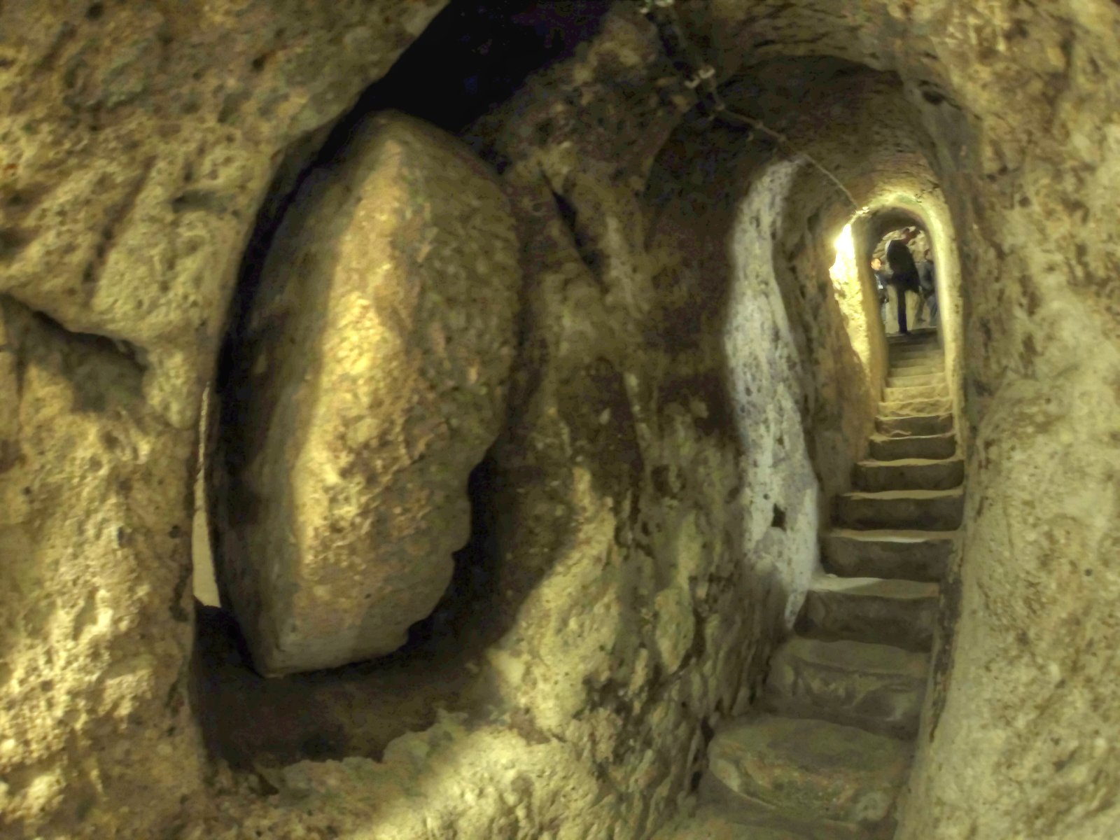
An 18-level city carved 85 metres into the Cappadocian rock, built to shelter up to 20,000 people from siege — complete with ventilation shafts, wine cellars, schools, and rolling stone doors no army could breach from outside.
At a glance
Derinkuyu is the deepest of roughly 36 underground cities discovered in Cappadocia’s Nevşehir Province. Its 18 storeys descend to approximately 85 metres below the surface, connecting stables, storage chambers, wine and oil presses, communal kitchens, chapels, and schools through a labyrinth of ventilated tunnels. Circular basalt doors — each weighing several tonnes and operable only from the inside — sealed individual levels during sieges. An 8-kilometre underground passage links it to the nearby city of Kaymakli, turning two separate refuges into a single interconnected underground system capable of sustaining its population for months at a time.
Key facts
- Period: c. 8th–7th century BC (Phrygian origins); expanded through Byzantine era, c. 5th–10th century AD
- Discovery: 1963, by a local resident demolishing walls in his home; opened to tourism 1969
- Scale: 18 storeys; approximately 85 m deep; capacity estimated at 20,000 people plus livestock
- Status: Open to the public; UNESCO Tentative List
- Access: Town of Derinkuyu, Nevşehir Province; designated entry with guided sections
History
The earliest layers of Derinkuyu were likely cut by the Phrygians in the 8th or 7th century BC as storage spaces and emergency shelters in a region where the soft volcanic tuff — ignimbrite — could be shaped with simple tools. The Phrygians built above ground too, but the rock beneath Cappadocia offered something surface architecture could not: near-total invisibility. Over the following centuries the city was expanded, deepened, and refined by successive populations navigating the turbulent corridors of Anatolian history.
Its most intensive period of use came during the early Christian era, when communities facing Roman persecution and, later, Arab raids in the 7th and 8th centuries AD descended into the rock for protection. Byzantine Christians adapted existing chambers into chapels and carved crosses into the walls. The name Derinkuyu — Turkish for “deep well” — reflects the settlement of Seljuk and Ottoman populations who recognised the feature above all else: the shafts that brought air and water down through 18 levels of stone.
The city was forgotten by the wider world until 1963, when a resident of the modern town of Derinkuyu, demolishing an internal wall of his house, broke through into a room that led to another, and then to a tunnel, and then to a world that had been sealed for centuries. Systematic archaeological investigation followed, revealing a complex whose full extent is still not entirely mapped.
What you see
Descending into Derinkuyu means entering a world built entirely at human scale — or rather, built for survival, not comfort. The tunnels are narrow enough that an invader would have to stoop and enter single-file; the ceilings in communal spaces rise just enough to stand. Ventilation shafts — over 52 of them, connecting all 18 levels — draw cool air through the stone, and the temperature holds at a constant 13°C regardless of the season above. At certain points, where the shafts align, you can hear the wind moving through the rock like breath.
The rolling stone doors are the most visceral detail: circular basalt discs, 1.5 metres in diameter, set into grooves carved into the tunnel floor and walls. Each could be rolled across a passage in seconds and secured with a wooden beam from the inside. No force from outside could shift them. On the lower levels, where the chapels and schools were placed — the most protected point of the entire city — the ceilings are slightly higher, the carving slightly more deliberate, as if the builders understood that faith and learning needed a different quality of space.
Practical information
- Opening hours: April–October 08:00–19:00; November–March 08:00–17:00
- Best season: Spring (April–May) and autumn (September–October) for mild surface temperatures; the underground stays 13°C year-round
- Duration: 1.5–2 hours for a thorough visit
- Notes: Some passages are low and narrow; not recommended for severe claustrophobia. Photography permitted without flash on most levels.
Getting there
The nearest airport is Nevşehir Kapadokya Airport (NAV), approximately 40 km away, with connections to Istanbul and Ankara. Kayseri Airport (ASR) is 90 km distant with broader international routes. From Nevşehir city, dolmuş (shared minibus) services run to Derinkuyu town. Most visitors base themselves in Göreme or Ürgüp and join organised day tours that combine Derinkuyu with Kaymakli underground city.
Nearby
- Kaymakli Underground City — 10 km north, connected by an 8 km subterranean passage
- Göreme Open Air Museum — 30 km north; Byzantine rock-cut churches with intact frescoes
- Uçhisar Castle — 35 km north; highest natural rock citadel in Cappadocia
- Ihlara Valley — 40 km west; 14 km canyon with carved churches along the river
Sources
- Wikipedia: Derinkuyu underground city
- Turkish Ministry of Culture and Tourism: Derinkuyu entry
- Nevşehir Provincial Culture and Tourism Directorate
Find it on the map
See this place and what’s around it →📷 Become a Cultural Heritage Online photographer
Share your photos of places: they stay published under your name as the author. The more they're seen, the more you get noticed — and soon a contest will reward the most appreciated photos.
Log in or sign up free to add a photo