Stari Grad Plain
On the Dalmatian island of Hvar, a flat fertile valley contains the oldest surviving land cadastre in the world: field boundaries laid out by Greek colonists in 384 BC that are still used by farmers today, 2,400 years later.
At a glance
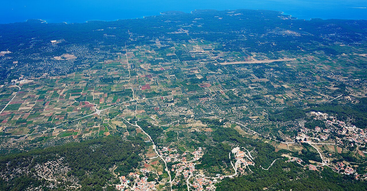
The Stari Grad Plain (Starogradsko polje) is a flat agricultural valley 6 kilometres long and 1.5 kilometres wide on the Dalmatian island of Hvar. In 384 BC, Greek colonists from the island of Paros founded the settlement of Pharos — modern Stari Grad, meaning “Old Town” — and divided the surrounding land among the first settlers using a precise geometric system of rectangular plots. They called each standard plot a kleros, measuring approximately 180 metres by 900 metres. The remarkable fact about Stari Grad Plain is that 73 per cent of this original land division survives intact in the current cadastral survey. The drystone walls the Greek colonists built are still standing and still maintained; the olive groves and vineyards still produce; and the field boundaries established 24 centuries ago still determine who farms which strip of land. UNESCO inscribed the site in 2008, calling it “an exceptional example of the continuity of man’s cultural relationship with the land.”
Key facts
- Founded: 384 BC by Greek colonists from Paros; settlement called Pharos (modern Stari Grad)
- UNESCO inscription: 2008, as “Stari Grad Plain”
- Area: approximately 9 km² of agricultural plain
- Land division unit: kleros — rectangular plot approximately 180 m × 900 m
- Survival rate: 73% of the original Greek geometric land division survives in today’s cadastral records
- Current crops: olive oil, wine (especially Plavac Mali grape), lavender — the same products as in antiquity
- Island: Hvar, Dalmatia, Croatia; Stari Grad is the oldest town on Hvar and one of the oldest continuously inhabited towns in Europe
History
In 384 BC, the island of Paros in the Aegean sent a group of colonists to establish a settlement on a large Adriatic island the Greeks called Pharos — the island we know today as Hvar. The colonists chose a site on a natural harbour at the western end of a long fertile valley and named their polis Pharos. The valley — the Stari Grad Plain — was the agricultural foundation of the settlement, and the colonists needed to divide it equitably among the founding families.
The Greek surveyors used a system called chora — the agricultural zone of a polis — and divided the plain into a precise rectangular grid of standard plots (kleroi), each measuring approximately 180 by 900 metres. The boundaries were marked with drystone walls built from the limestone rock cleared from the fields, and access roads (called decumani) were laid between the rows of plots. The system gave each founding family an equal share of land and an equal portion of both the fertile valley floor and the hillside margins.
The Roman conquest of Pharos in 219 BC ended Greek political independence, but the agricultural system on the plain was not disrupted — Roman farmers worked the same plots with the same boundaries. The Byzantine period, the medieval Croatian kingdom, Venetian rule from 1278 onwards, the Habsburg Empire, and finally Yugoslavia and independent Croatia all passed over the plain without fundamentally altering the land division. Some boundaries shifted, some plots merged or split, and Byzantine-era watchtowers and small chapels were added within the ancient grid. But the basic geometric structure survived.
The 20th century brought mechanisation but not destruction. Local farmers continued to maintain the drystone walls rather than remove them because the walls serve a practical purpose: they retain moisture, protect against erosion, and divide family holdings whose ownership records trace back through centuries of notarial records still held in Stari Grad. When surveyed systematically in the late 20th century, cadastral researchers found that 73 per cent of the original Greek division was still legible on the ground and legally registered.
What you see
The best way to comprehend Stari Grad Plain is from above — on the hillside road approaching Stari Grad from Jelsa, or on any satellite image. From elevation, the Greek geometry is unmistakable: parallel lines of drystone walls running from the sea to the mountain in perfect order, creating a grid of long rectangles across the valley floor. The regularity is almost startling in a landscape otherwise shaped by natural contours.
On the ground, walking through the plain feels like moving through a continuously inhabited Mediterranean agricultural landscape. The drystone walls are low — knee to waist height — and ancient in their appearance: grey limestone, fitted without mortar, colonised by lizards and wild herbs. The olive trees within the plots are old; some are centuries old. The paths between the fields follow the original Greek access roads. Occasional Byzantine chapels stand at plot boundaries. A few Roman-era structures have been identified archaeologically within the grid.
In Stari Grad itself, the Archaeological Museum is housed in the Renaissance estate of the poet Petar Hektorović (Tvrdalj), which includes a remarkably preserved fish pond and garden. The museum documents the Greek, Roman, and medieval history of Pharos with artefacts from the plain and the harbour area.
Practical information
- Access: the plain is open agricultural land, freely walkable via farm tracks; no entrance fee
- Stari Grad Archaeological Museum: located in Tvrdalj (Hektorović estate); seasonal opening hours — check locally
- Best time to visit: May–June (before peak tourist season) and September–October; the plain is beautiful in all seasons but summer sees high tourist traffic on Hvar island generally
- Guided tours: local guides available through the Stari Grad tourist office; recommended for understanding the cadastral grid
- Photography: unrestricted on foot paths; drone photography requires Croatian Civil Aviation Authority permit
Getting there
Stari Grad is reached by ferry from Split on the Croatian mainland; the ferry terminal is in Stari Grad itself (the main island car ferry route). From Split, ferries operate multiple times daily in summer and less frequently off-season (crossing approx. 2 hours). The plain extends directly behind the town and is walkable from the ferry terminal. The island of Hvar also has a catamaran connection to Split (Hvar Town, not Stari Grad). Hvar Town is approximately 20 km east of Stari Grad by road.
Nearby
- Hvar Town — the main tourist centre of the island, with a Venetian loggia, the oldest public theatre in Croatia (1612), and the Fortica fortress; approximately 20 km east
- Tvrdalj (Hektorović Estate) — 16th-century Renaissance fortified manor in Stari Grad with preserved fish pond, garden, and archaeological museum
- Pakleni Islands — archipelago of small islands immediately west of Hvar Town; accessible by water taxi
Sources
- UNESCO World Heritage List, Stari Grad Plain (2008), whc.unesco.org
- Wikipedia, Stari Grad Plain, en.wikipedia.org
- Kirigin, Branko. Pharos — the Island of Hvar in the Hellenistic Period. Zagreb, 2006.
- Croatia Ministry of Culture and Media — Stari Grad Plain heritage documentation
Find it on the map
See this place and what’s around it →📷 Diventa un fotografo di Cultural Heritage Online
Condividi le tue foto dei luoghi: restano pubblicate con la tua firma come autore. Più vengono viste, più ti fai conoscere — e presto un concorso premierà le foto più apprezzate.
Accedi o registrati gratis per aggiungere una foto