Kuelap
A walled citadel six hundred metres long and nineteen metres high, built by the Chachapoyas — the Warriors of the Clouds — at 3,000 metres above sea level in northern Peru’s cloud forest.
At a glance
Kuelap occupies a mountain ridge above the Utcubamba Valley in the Amazonas region of northern Peru, reachable since 2017 by a cable car that climbs 1,000 metres over sixteen minutes of jungle and cloud. Built from the 9th century AD and occupied until shortly after the Spanish conquest, the citadel was the largest pre-Columbian construction in South America by volume of stonework — a claim that stands despite Machu Picchu’s fame. It remained unknown to the outside world until Peruvian jurist Juan Crisóstomo Nieto described it in 1843. Fewer than 100,000 people visit annually, compared to 1.5 million at Machu Picchu; the silence on the platform, broken only by cloud and wind, is part of what the site offers.
Key facts
- Location: Amazonas Region, Peru — 6.4221° S, 77.9244° W (Google Maps)
- Period: c. 900–1570 AD; Chachapoyas culture; conquered by the Inca c. 1470 AD
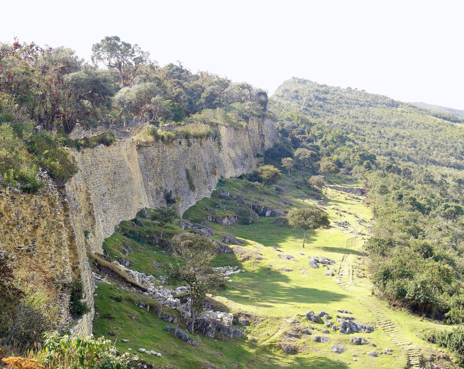
- Scale: Platform 600 m long, 110 m wide; exterior walls up to 19 m high; roughly 420 circular stone structures inside
- Stonework volume: Estimated larger than the Great Pyramid of Giza by total stone mass
- Cable car: Inaugurated 2017; 16-minute ride from Nuevo Tingo (1,800 m) to site level (3,000 m)
- Discovery: Juan Crisóstomo Nieto, 1843; systematic excavation began with Peruvian archaeologist Federico Kauffmann Doig in the 20th century
History
The Chachapoyas — whose name in Quechua means “Warriors of the Clouds” or “People of the Clouds” — occupied the northeastern Andean cloud forests from at least the 8th century AD. They were distinct from the coastal Chimú and highland Tiwanaku cultures, building in a characteristic style of circular stone structures rather than the rectangular rooms of Andean highland tradition. Kuelap was their primary settlement and ceremonial centre; its three-layered platform, built up over centuries of construction, eventually enclosed some 420 round buildings whose interiors show evidence of habitation, storage, and ritual activity.
Around 1470 AD the Inca under Tupac Inca Yupanqui conquered the Chachapoyas after a prolonged resistance. The Inca modified parts of Kuelap — a circular building at the site’s south end shows Inca construction techniques overlaid on a Chachapoyas base — but largely left the structure intact, using it as an administrative centre. The Spanish conquest effectively ended occupation by the early 17th century; the forest and cloud recovered the site. Juan Crisóstomo Nieto reached Kuelap in 1843 and published a description, but systematic archaeological work did not begin until Federico Kauffmann Doig’s surveys in the 1960s. Conservation and partial restoration have proceeded under the Peruvian Ministry of Culture since the 1990s; the cable car, opened in 2017 and the first of its kind in Peru, increased visitor access dramatically.
What you see
The approach by cable car is disorienting in the best possible way: you rise out of the valley’s heat and tropical vegetation into cloud, and the mountain above you disappears. The platform materialises as a long limestone wall above the treeline — not a pyramid’s pointed silhouette but a flat-topped fortification, its exterior walls presenting three narrow funnel-shaped entrances wide enough for a single person at a time, a design that forced attackers to enter one by one and made the citadel militarily impenetrable by any pre-gunpowder force.
Inside, the 420 circular structures are of varying sizes, their walls decorated with diamond and zigzag friezes in low relief — a Chachapoyas motif also found at other sites in the region, from Karajía to Revash. The largest structure is the Tintero (“inkwell”), a truncated inverted cone whose function remains debated. At the southern end, the Inca-period circular building stands in visible contrast to the surrounding Chachapoyas work: tighter stonework, trapezoidal niches. Cloud moves through the site at intervals, erasing and revealing sections of wall; the temperature drops ten degrees in minutes when it does.
Practical information
- Opening hours: Daily 8:00–16:00 (last cable car up at 15:00); cable car departs from Nuevo Tingo
- Tickets: Site entrance plus cable car ticket purchased separately; advance booking recommended in peak season (July–August)
- Best season: April–October (dry season); the site is open year-round but trails become slippery in the wet season (November–March)
- What to wear: Warm layers essential — temperature at 3,000 m drops rapidly; waterproof jacket; sturdy shoes for uneven stone surfaces
- Altitude: 3,000 m — acclimatise in Chachapoyas (2,335 m) for at least one night before visiting
- Time needed: 2–3 hours on site; half day including cable car and approach
Getting there
The nearest city is Chachapoyas (77 km by road), the regional capital of Amazonas, accessible by bus from Chiclayo (9–10 hours) or Lima (22+ hours). From Chachapoyas, the cable car base station at Nuevo Tingo is reached by a 1.5-hour drive on an unpaved mountain road. Organised day tours from Chachapoyas are the most practical option. There is no commercial airport at Chachapoyas; the nearest international connections are at Chiclayo (Capitán José Abelardo Quiñones Gonzales Airport) on the Pacific coast.
Nearby
- Karajía — 37 km north: Chachapoyas sarcophagi set into a cliff face at altitude, the figures still wearing their original painted headdresses
- Gocta Waterfall — 40 km north: one of the world’s tallest waterfalls (771 m), “unknown” to the outside world until 2006
- Revash — 50 km south: Chachapoyas cliff mausoleums in a dramatic canyon landscape
- Chachapoyas city — 77 km south: colonial-era city with a daily market and the regional museum holding Chachapoyas artefacts
Sources
- Kauffmann Doig, Federico. Arqueología de los Chachapoyas. Instituto de Arqueología Amazónica, 1996.
- Wikipedia — Kuelap: en.wikipedia.org/wiki/Kuelap
- Ministerio de Cultura del Perú — Kuelap official site: cultura.gob.pe
- Schjellerup, Inge. Incas and Spaniards in the Conquest of the Chachapoyas. Gothenburg, 1997.
Find it on the map
See this place and what’s around it →📷 Diventa un fotografo di Cultural Heritage Online
Condividi le tue foto dei luoghi: restano pubblicate con la tua firma come autore. Più vengono viste, più ti fai conoscere — e presto un concorso premierà le foto più apprezzate.
Accedi o registrati gratis per aggiungere una foto