Great Barrier Reef
The largest coral reef system on Earth and one of the most biodiverse marine ecosystems in the world — the Great Barrier Reef stretches 2,300 km along the Queensland coast of Australia, is visible from space, and supports more than 1,500 species of fish; it is also the marine ecosystem most severely affected by climate change, with approximately half its shallow-water corals killed by ocean warming since 1998.
At a glance
The Great Barrier Reef (344,400 km²; established as the Great Barrier Reef Marine Park in 1975; UNESCO WHS 1981; the largest marine park in the world) extends from Bundaberg in the south (24° S) to the Torres Strait in the north (10° S), a total length of approximately 2,300 km along the Queensland coast; it lies between 15 and 150 km offshore; the main visitor gateways are Cairns (the most popular; direct international flights; most reef pontoons and dive operators based here), Port Douglas (a more upmarket gateway, 70 km north of Cairns; the reef is closer to the coast here), the Whitsunday Islands (the central section; the most sheltered; accessible from Airlie Beach; the Whitsunday Islands are continental islands with fringing reefs), and Bundaberg/Lady Elliot Island (the most southerly section; the site of the highest coral cover remaining on the reef, paradoxically, because of less tourism pressure and the Coral Sea current patterns); access is primarily by boat (day trips by fast catamaran from Cairns to reef pontoons, approximately 90 min each way; liveaboard dive boats; seaplane to outer reef sections) or by helicopter; the reef is almost never seen from land (the continental shelf edge where the reef begins is too far offshore to see).
Key facts
- The coral bleaching crisis: the most urgent conservation emergency in marine biology — coral bleaching occurs when ocean water temperatures exceed the thermal tolerance of the symbiotic algae (zooxanthellae) that live in coral tissue and provide up to 90% of the coral’s energy through photosynthesis; when temperatures exceed 1°C above the long-term summer maximum for 8+ weeks, the coral expels the zooxanthellae — without them, the coral skeleton becomes visible (pure white = “bleached”) and the coral slowly starves; if temperatures return to normal within 4–8 weeks, the coral can recover by reabsorbing algae; if the thermal event lasts longer, the coral dies and becomes colonised by algae (green or brown, not white); the 2016 bleaching event was the worst in recorded history — surveys found that 30% of all shallow-water corals on the Great Barrier Reef died; the 2022 event, which occurred during a La Niña year (traditionally cooler), affected all sections of the reef simultaneously for the first time, demonstrating that climate background warming has exceeded the La Niña cooling effect; approximately 50% of all coral cover on the reef has been lost since 1995; the AIMS (Australian Institute of Marine Science) long-term monitoring programme documents the ongoing change
- The marine biodiversity: one of the most complex ecosystems on Earth — the Great Barrier Reef supports: 1,500 species of fish (including the Potato Cod at Cod Hole, Ribbon Reef, which have been hand-fed by divers since the 1970s and are now completely habituated — 80 kg groupers that swim towards divers to be touched), 4,000 types of mollusc (including the Giant Clam, Tridacna gigas, the world’s largest bivalve, up to 1.3 metres and 250 kg; the colours of giant clam mantles — electric blue, green, brown, purple, turquoise — are produced by the same zooxanthellae that live in coral), 240 species of bird, 6 of the world’s 7 sea turtle species (the Green Turtle nesting sites on Raine Island, the largest green turtle nesting rookery in the world, approximately 60,000 females per season), the Dugong (Dugong dugon; the “sea cow”; a large marine mammal related to the elephant; approximately 10,000 in the Great Barrier Reef area — the second largest dugong population in the world; they feed on seagrass meadows in the shallow inner reef areas), and the Dwarf Minke Whale (Balaenoptera acutorostrata subspecies; the most reliably encountered large whale for snorkellers; approximately 40–50 individuals visit the Ribbon Reefs north of Cairns each year in June–July; divers have been allowed to enter the water with approaching minke whales since 2003)
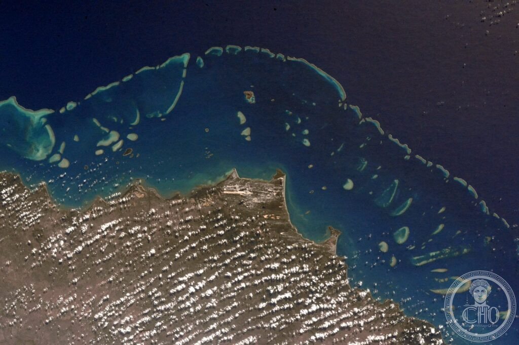
- The reef from above (aerial experience): the largest living structure visible from space and the most visually spectacular natural landscape in Australia — the Great Barrier Reef from the air (helicopters and seaplanes depart from Cairns and the Whitsundays; 30–60 min flights over the outer reef sections; the view includes: the clear-water lagoon between the outer reef wall and the coast (lighter blue, shallow, sheltered), the outer reef edge where the coral wall drops to 2,000 metres (the reef crest, white with breaking waves, is the most distinct line in the aerial view), the reef flats behind the crest (maze-like patterns of coral and sand), the patch reefs (isolated circular coral formations in the lagoon), and the ribbon reefs (long narrow parallel reef formations in the northern section) — from the air, the reef looks exactly like a landscape built to be viewed from above, which no human intended but which the aerial view makes the most dramatic natural landscape in Australia)
- Heritage: UNESCO World Heritage Site, Great Barrier Reef, inscribed 1981
- GPS: -18.2861° S, 147.6992° E
History
The Great Barrier Reef has been known to the Aboriginal and Torres Strait Islander peoples for approximately 60,000 years; the reef was charted by James Cook in 1770 (HMS Endeavour ran aground on the reef on 11 June 1770 — it was refloated after 24 hours and limped to shore near present-day Cooktown for repairs); the reef was established as a Marine Park in 1975 (the Great Barrier Reef Marine Park Act); UNESCO WHS 1981; the first recorded major bleaching event was in 1998 (associated with the strong El Niño of 1997–1998); successive bleaching events in 2002, 2016, 2017, 2020, 2022, and 2024 have dramatically reduced coral cover; the Australian government’s lobbying successfully prevented World Heritage In Danger listing in 2015 and 2021 despite IUCN recommendations to list; the reef was included in the 2022 IPCC report as one of the marine ecosystems most severely affected by anthropogenic climate change.
What you see
The visitor experience: outer reef pontoon day trips from Cairns (the standard first visit; a semi-submersible viewing chamber and snorkelling give access to the reef without diving certification; the pontoons are anchored on permanent reef sites that are managed to maintain coral cover; Hardy Reef pontoon near the Whitsundays is the most photogenic); scuba diving (the Ribbon Reefs north of Cairns are the highest quality dive sites accessible on a standard liveaboard; the Cod Hole at Ribbon Reef No. 10 has the most famous dive site on the entire reef — the resident Potato Cod); the Whitsundays (74 islands with white silica sand beaches — Whitehaven Beach is consistently rated the best beach in Australia; fringing coral reefs around the islands; calm sheltered sailing; the Whitsunday Islands are continental islands, not coral atolls, but they have fringing coral reefs); Lady Elliot Island (the southernmost coral cay on the reef; 80 min by small plane from Brisbane or Bundaberg; the highest live coral cover on any part of the accessible reef; manta ray cleaning station; sea turtle nesting).
Practical information
- Getting there: Cairns Airport (CNS; direct international flights from Tokyo, Singapore, Hong Kong, Osaka, and many Pacific routes as well as extensive domestic connections from Sydney, Melbourne, Brisbane, Perth; the international hub for reef access); Proserpine/Whitsunday Coast Airport (PPP; near Airlie Beach; for the Whitsundays section; domestic flights from Brisbane, Sydney, Melbourne); the reef itself is accessed by boat (fast catamaran day trips from Cairns or Port Douglas; 90 min each way to outer reef; approximately AUD $200–280 per person for a day trip with snorkel and lunch; dive certified visitors add AUD $60–100 for 2 dives) or seaplane/helicopter (AUD $300–500 for a 30–60 min flight)
- Responsible visiting: the reef is in measurable decline and visitor pressure is one contributing factor; guidelines for reducing reef impact: do not stand on coral (one step kills 20+ years of coral growth), do not touch marine animals, wear reef-safe sunscreen (chemical UV filters oxybenzone and octinoxate are toxic to coral and banned in some reef-adjacent areas), do not take any marine organism, support operators with Great Barrier Reef Marine Park Authority (GBRMPA) certification for their environmental management practices; GBRMPA has a “High Standard Operator” accreditation for the best operators
- Best season: the dry season (May–October; lower rainfall, lower water temperature — 22–26°C vs 27–31°C in summer; lower stinger (jellyfish) risk; calmer seas) is the recommended visit season; the wet season (November–April; higher temperatures; the risk of tropical cyclones, which can damage the reef and close areas; “stinger season” — the Box Jellyfish (Chironex fleckeri) and Irukandji Jellyfish, which are dangerous to fatal, are present in inshore waters November–May and require stinger suit use when swimming; the reef itself is outside the stinger zone)
Getting there
Cairns Airport (CNS) — international hub for reef access. Day trips 90 min by catamaran, ~AUD $200–280. GPS: -18.2861, 147.6992.
Nearby
- Daintree Rainforest (Queensland) — 90 km north of Cairns (1h 30 min by road; the Cape Tribulation section where the rainforest meets the reef is 130 km from Cairns); the oldest continuously surviving tropical rainforest on Earth, older than the Amazon — the Daintree Rainforest (Wet Tropics of Queensland UNESCO WHS 1988; approximately 7,000 km² of lowland and montane tropical rainforest north of Cairns; part of the Wet Tropics, which has been forested since the Gondwana era 130+ million years ago — making it the oldest tropical rainforest still in existence, predating the Amazon by approximately 100 million years; 12 of the 19 most primitive flowering plant families on Earth are found here, nowhere else; the cassowary — the second-largest bird in the world after the ostrich; a flightless bird with a razor-sharp inner toe; cassowaries are critically important seed dispersers for the Daintree and are occasionally seen crossing the Cape Tribulation road) can be visited on a day trip from Cairns (most tours combine the Daintree with Cape Tribulation beach and the Mossman Gorge)
- Uluru-Kata Tjuta National Park (Northern Territory) — 2h 30 min by flight from Cairns to Ayers Rock Airport (AYQ); one of the most sacred landscapes in Australia and the most iconic rock in the world — Uluru (also called Ayers Rock; the Anangu people’s sacred name is Uluru; a sandstone monolith 348 metres high, 9.4 km in circumference, and 2.5 km wide; the exposed rock above ground represents only the tip of a much larger underground formation; the surface of Uluru changes colour dramatically from rust-red to orange to deep violet-red depending on time of day and atmospheric conditions; the most intense colours are at sunrise and sunset; the climbing of Uluru was permanently closed in October 2019 at the request of the Anangu traditional owners — the rock is sacred and the Anangu had requested the closure since the 1985 handover of the land; Kata Tjuta (the Olgas; 36 domed rock formations grouped around a central valley; equally sacred; the Valley of the Winds walk between the domes is one of the most dramatic short walks in the Australian outback) are 50 km west)
- Ningaloo Reef (Western Australia) — 4h by flight from Cairns to Exmouth (via Perth); the world’s largest fringing reef (one that extends directly from the shore without a lagoon) and the best place in the world to snorkel with whale sharks — Ningaloo Marine Park (UNESCO WHS 2011; 300 km of fringing reef along the Exmouth Peninsula of Western Australia; unlike the Great Barrier Reef, Ningaloo is accessible from shore without a boat in many places; the whale shark aggregation (Rhincodon typus; the world’s largest fish; up to 18 metres; feeds entirely on plankton and small fish by filter-feeding; completely harmless; the Ningaloo aggregation of 300–500 whale sharks occurs March–August when coral spawning provides food; the swim-with-whale-shark experience is the most popular tourism activity in Western Australia)
Sources
- Wikipedia, Great Barrier Reef; Coral bleaching; Dugong, accessed June 2026
- UNESCO, Great Barrier Reef, WHS reference 154, inscribed 1981
- Australian Institute of Marine Science (AIMS), Long-Term Monitoring Program: Annual Summary Report of Coral Reef Condition 2023–24, AIMS, 2024
Find it on the map
See this place and what’s around it →📷 Diventa un fotografo di Cultural Heritage Online
Condividi le tue foto dei luoghi: restano pubblicate con la tua firma come autore. Più vengono viste, più ti fai conoscere — e presto un concorso premierà le foto più apprezzate.
Accedi o registrati gratis per aggiungere una foto