Dolomiti
Le Dolomiti (UNESCO 2009, rif. 1237) sono riconosciute come il paesaggio montano di maggiore bellezza estetica del mondo — 9 sistemi dolomitici tra Trentino-Alto Adige, Veneto e Friuli per 141.903 ettari di torri verticali, pinnacoli e pareti di dolomia che al tramonto virano dal bianco all’arancio (l’“Enrosadira”).
At a glance
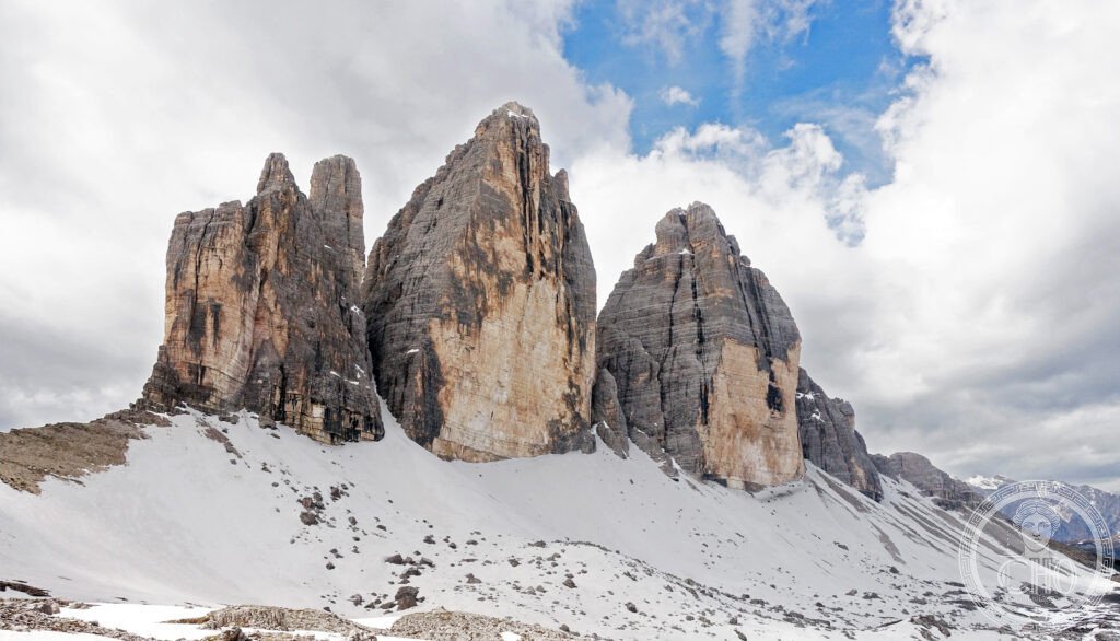
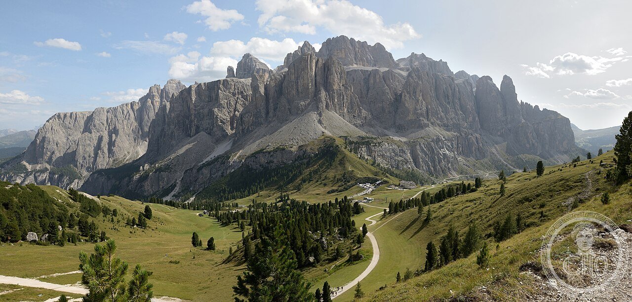
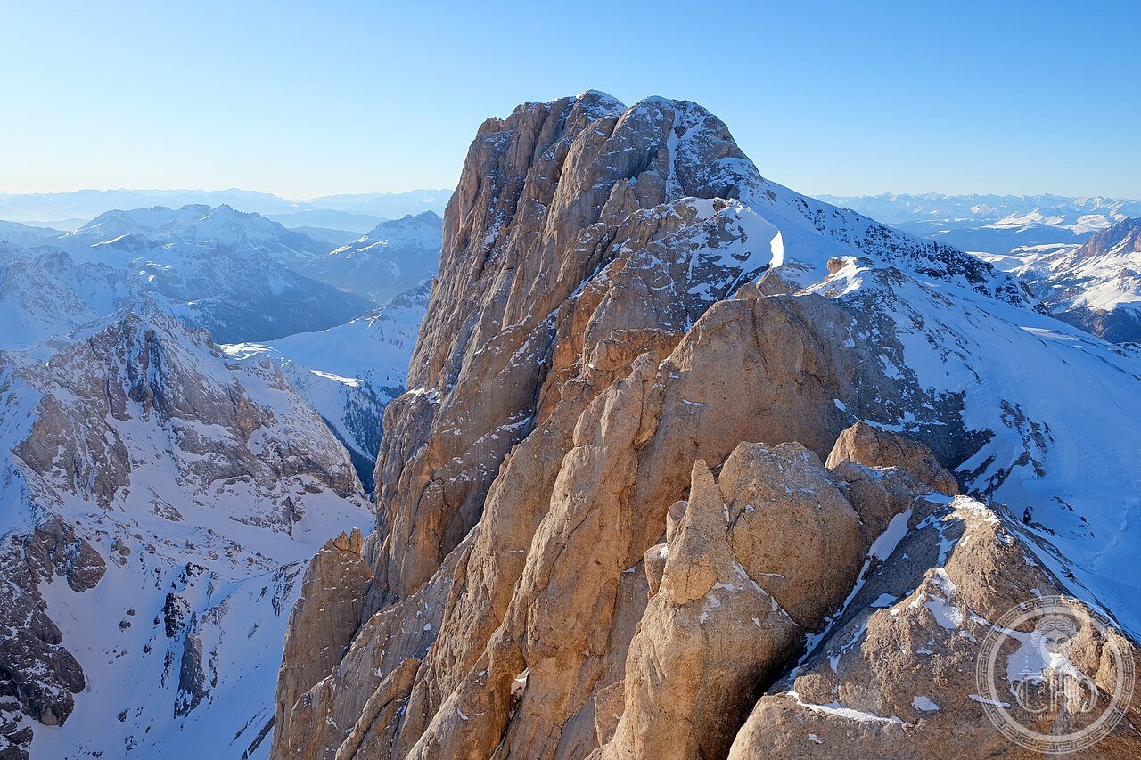
Dolomiti Trentino Alto Adige Veneto (the most precisely Dolomiti zone 46.5057 N 12.0072 E (Tre Cime di Lavaredo approximate centroid) UNESCO WHS 2009 reference 1237 Dolomites: the site (the UNESCO Dolomites: 9 separate mountain systems inscribed as a serial site (serial site = multiple properties in separate locations inscribed as a single World Heritage property; a serial site is appropriate when no single component could represent the outstanding universal value alone; the Dolomites were inscribed as a serial site because no single mountain valley or massif contains all the outstanding geological, geomorphological, and aesthetic features); the 9 systems: (1) Pelmo, Croda da Lago (Veneto; 6,538 ha); (2) Marmolada (Trentino-Veneto; 3,354 ha: the “Queen of the Dolomites”; 3,343 m; the largest glacier in the Dolomites: Ghiacciaio della Marmolada (the Marmolada glacier: surface area 1910 CE: 5.5 km²; surface area 2023 CE: 0.9 km² = 84% loss in 113 years: the fastest-retreating glacier in the Alps; the Marmolada Serac collapse (July 3, 2022 CE: a 7 million m³ section of the Marmolada glacier collapsed, killing 11 climbers on the normal route; the cause: the record heat of July 2022 CE (the temperature at 3,343 m reached 10°C (18°C above the historical mean); the ice was melted at the base of the serac, losing its adhesion))); (3) Pale di San Martino, San Lucano, Dolomiti Bellunesi, Vette Feltrine (Veneto; 68,264 ha: the largest of the 9 systems; the Pale di San Martino (the most extensive high plateau in the Dolomites: 57 km² at 2,500–2,800 m above sea level; the Cima della Vezzana: 3,192 m; the Cimon della Pala: 3,184 m (the “Matterhorn of the Dolomites”: the most photographed peak of the Pale di San Martino))); (4) Dolomiti Friulane e d’Oltre Piave (Friuli; 24,740 ha); (5) Dolomiti Settentrionali/Sextner Dolomiten (Alto Adige-Veneto; 10,265 ha: the Tre Cime di Lavaredo + Cristallo + Croda Rossa); (6) Puez-Odle/Geisler (Alto Adige; 11,160 ha); (7) Sciliar-Catinaccio, Latemar (Alto Adige; 6,383 ha: the Rosengarten/Catinaccio massif); (8) Bletterbach (Alto Adige; 762 ha: the geological gorge (1 km deep) exposing 250 million years of geological history); (9) Dolomiti di Brenta (Trentino; 39,744 ha: the Cima Tosa 3,173 m; the Brenta Group: the only Dolomites west of the Adige valley)).
Key facts
- La scoperta mineralogica delle Dolomiti da parte di Déodat de Gratet de Dolomieu nel 1789 CE e perché la roccia che dà il nome alla catena non era mai stata identificata prima: the geological discovery (Déodat de Gratet de Dolomieu (1750–1801 CE): the French geologist who identified the distinctive rock of the Dolomites as a new mineral in 1789 CE; Dolomieu’s method: he was given 2 samples of rock from the mountains by Horace-Bénédict de Saussure (1740–1799 CE; the Swiss scientist who first climbed Mont Blanc in 1787 CE; the founder of Alpine science (the term “geology”: Saussure coined it in 1779 CE)); Dolomieu’s test: he placed the rock sample in dilute hydrochloric acid (HCl): normal limestone (CaCO&sub3;) fizzes vigorously in HCl (the chemical reaction: CaCO&sub3; + 2HCl → CaCl&sub2; + H&sub2;O + CO&sub2;); the Dolomieu sample fizzed only weakly when cold and vigorously when heated (the chemical explanation: dolomite (CaMg(CO&sub3;)&sub2;) is less reactive with cold HCl because the Mg²²²² ion forms a protective lattice that slows acid penetration; this is the field test for dolomite vs limestone still used by geologists in 2026 CE); Dolomieu published his findings in 1791 CE in the “Journal de Physique” (the first scientific journal in France); the mineral was named “dolomie” by Nicolas de Saussure (Horace-Bénédict’s son) in 1792 CE in his honor; the mountain range was named “Dolomites” by Brocchi in 1821 CE);
- GPS (Tre Cime di Lavaredo, Rifugio Auronzo parcheggio base trail): 46.6175° N, 12.3012° E
History
Da Dolomieu 1789 CE al UNESCO 2009 (the most precisely Dolomiti zone history: the geological history (the Dolomites: the geological origin: the Dolomites were formed on the bottom of a shallow tropical sea (the Tethys Sea: the ocean that covered what is now Europe, the Middle East, and Central Asia from 250 million BCE to 65 million BCE); the process: (1) 250 million BCE: coral and sponge reefs grew in the warm Tethys Sea, forming limestone banks (the “reef facies”: the original Dolomite rock is a shallow-water reef limestone (bioclastic calcarenite: limestone composed of fragments of coral, shells, and algae); the thickness of the reef limestone: up to 3,000 m); (2) 65–35 million BCE: the collision of Africa and Europe (the Alpine orogeny) pushed the Tethys Sea floor 3,000 m upward, creating the Alps and Dolomites; (3) 2 million BCE–10,000 BCE: the Pleistocene glaciation (the Dolomites were covered by glaciers up to 1,500 m thick: the U-shaped valleys (the Valles di Ampezzo, the Pusteria valley) were carved by glaciers; the pyramid-shaped peaks (the Tre Cime, the Cimon della Pala) were shaped by periglacial frost-shattering above the glaciers); the human history (the Ladins: the Ladin-speaking people of the Dolomites (the Ladin language: a Rhaeto-Romance language derived from Latin, spoken by approximately 25,000 people in the valleys of the Dolomites: the Badia valley, the Gardena valley, the Fassa valley, the Ampezzo basin, the Livinallongo valley; the Ladin people claim continuous habitation of the Dolomite valleys since the Roman conquest of 15 BCE)); the UNESCO inscription (2009 CE: reference 1237).
What you see
Le Tre Cime di Lavaredo, il giro delle Pale di San Martino, la Marmolada e il Gorge di Bletterbach (the most precisely Dolomiti zone visit (3–7 days for a meaningful circuit): the iconic trails: (1) the Tre Cime di Lavaredo circuit (the most photographed hike in the Alps: 9.7 km loop; 508 m elevation gain; 3–4 hours; difficulty: easy; start from Rifugio Auronzo (2,333 m: the highest point reachable by car in the Dolomites; the road toll: €30/car from July 1 to September 30; the hike: counterclockwise from Rifugio Auronzo → Locatelli refuge (the view of the 3 north faces) → Auronzo (back)); the best light: sunrise (the northeast face of the Tre Cime is lit from 6:30 to 9:00 AM; the Rifugio Auronzo opens at 6:00 AM)); (2) the Enrosadira at Alpe di Siusi (the Alpe di Siusi / Seiser Alm: the largest high alpine meadow in Europe (56 km²; 1,800–2,350 m); the Schlern/Sciliar massif behind (2,563 m); cable car from Ortisei / Castelrotto (€26 return): the Enrosadira visible from the meadow at 20:00–20:30 in June; the photography setting: 70–200mm telephoto + tripod + 10-stop ND filter (ISO 100, f/8, 30s = the standard setting for the sunset light on the Schlern)); (3) the Pale di San Martino plateau (San Martino di Castrozza cable car → Col Verde (2,003 m) → Rifugio Rosetta (2,581 m): the plateau (the “luna di pietra”: the “stone moon” = the 57 km² high plateau at 2,500 m with no vegetation, only white dolomite rock); accessible July–September only).
Practical information
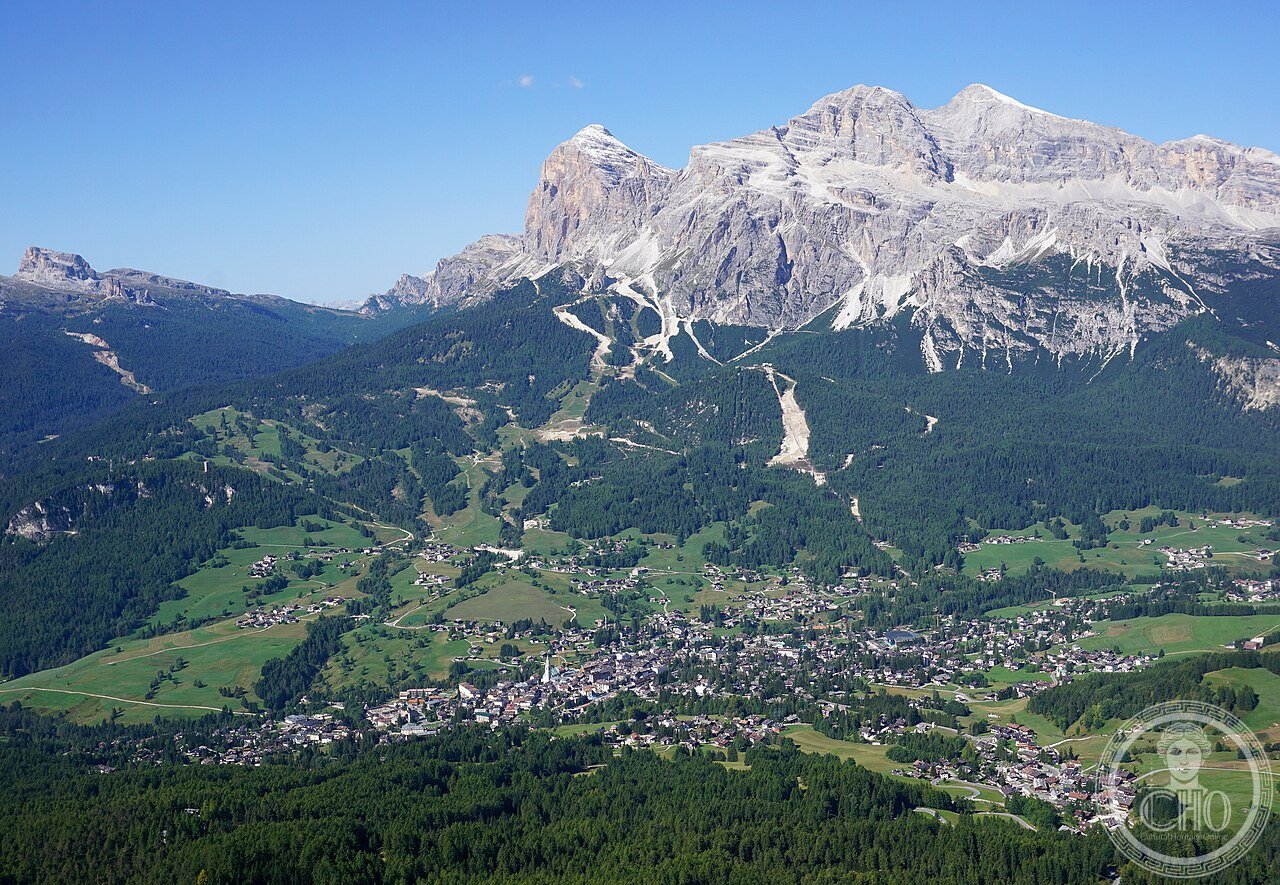
- Come muoversi nelle Dolomiti senza auto in estate e quali sono i migliori centri base per le varie aree: il trasporto (le Dolomiti senza auto (estate luglio-agosto): il Dolomiti Superski bus network (il sistema di bus gratuiti / a tariffa ridotta che collega le principali stazioni invernali in estate: il Cortina Express (Venezia → Cortina d’Ampezzo: 2h30; €16; 2 volte/giorno luglio-agosto); il FlixBus Bolzano → Cortina (2h; €15); la linea SAD Bolzano → Ortisei (1h10; €5.50; ogni ora da Bolzano Bus Terminal)); i centri base (il centro base per le Tre Cime di Lavaredo: Misurina (B&B da €60/notte; 6 km dal Rifugio Auronzo) o Cortina d’Ampezzo (hotel da €120/notte; 20 km dal Rifugio Auronzo); il centro base per le Pale di San Martino: San Martino di Castrozza (B&B da €70/notte; la stazione cable car per il plateau); il centro base per l’Enrosadira / Alpe di Siusi: Ortisei (B&B da €80/notte; cable car per l’Alpe di Siusi))
Getting there
Venezia Mestre → Cortina: FlixBus o Cortina Express (2h30, €16). Bolzano Treno → Ortisei area: SAD bus (1h10, €5.50). GPS Tre Cime: 46.6175/12.3012. Parcheggio Auronzo: €30/auto lug-set.
Nearby
- Venezia e Laguna (UNESCO 1987 rif. 394) — 170 km (Venezia Santa Lucia → Belluno: Trenitalia 1h30; poi bus SAD per le Dolomiti Bellunesi)
- Bolzano / Bozen e “Ötzi” il Museo delle Mummie (3300 BCE) — 70 km (Museo Archeologico dell’Alto Adige: Via Museo 43, Bolzano; €13; la mummia di ghiaccio ritrovata sul Similaun 1991 CE; la mummia più antica del mondo in buono stato di conservazione (5.300 anni); apertura 10:00–18:00 Tue-Sun)
Gallery
Sources
- Wikipedia, Dolomites; Tre Cime di Lavaredo; Déodat de Gratet de Dolomieu; Pale di San Martino, accessed June 2026
- UNESCO, Dolomites, WHS reference 1237, inscribed 2009
- Dolomieu, D. “Sur un genre de pierres calcaires peu effervescentes avec les acides.” Journal de physique 39 (1791): 3–10 (the original discovery paper)
Find it on the map
See this place and what’s around it →📷 Diventa un fotografo di Cultural Heritage Online
Condividi le tue foto dei luoghi: restano pubblicate con la tua firma come autore. Più vengono viste, più ti fai conoscere — e presto un concorso premierà le foto più apprezzate.
Accedi o registrati gratis per aggiungere una foto