Cappadocia
An entire landscape carved by humans into volcanic rock — starting with the early Christian communities of the 4th century who cut their churches, monasteries, and cities directly into the soft tuff, and continuing through the Byzantine period to produce cave frescoes that are among the finest Byzantine art outside Constantinople.
At a glance
Cappadocia (Turkish: Kapadokya) is a region of central Anatolia in Turkey defined by a landscape of volcanic tuff formations — “fairy chimneys” (conical volcanic pillars capped with harder basalt), valleys eroded from the soft rock, and underground cities cut deep into the earth. The region forms a rough triangle between the towns of Nevşehir, Ürgüp, and Avanos in the Nevşehir and Kayseri provinces. The cultural significance of Cappadocia lies in the extraordinary density of rock-cut architecture: an estimated 3,000 rock-cut churches and chapels, several underground cities (Derinkuyu and Kaymakli are the deepest), and the open-air museum of Göreme, which contains the finest concentration of Byzantine fresco programmes in Turkey. The Göreme National Park and the Rock Sites of Cappadocia are jointly inscribed as a UNESCO World Heritage Site (1985).
Key facts
- Geology: the landscape was formed by eruptions of Mount Erciyes and Hasan Dağı approximately 3 million years ago, which deposited deep layers of volcanic tuff (compressed ash) over the plateau; subsequent erosion by wind, water, and frost sculpted the soft tuff into its current formations; the harder basalt cap on many fairy chimneys erodes more slowly, giving the capped-mushroom profile
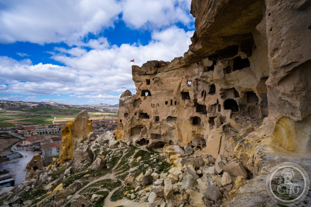
- Rock-cut architecture: estimated 3,000 rock-cut churches and chapels in the region; the oldest date from the 4th century AD; the richest fresco programmes are from the 10th–13th centuries; the Göreme Open-Air Museum (a UNESCO sub-site within the park) has the highest concentration, including the Dark Church, the Apple Church, and the Snake Church
- Underground cities: Derinkuyu (the deepest, 85 metres underground, capable of sheltering 20,000 people) and Kaymakli (the largest in surface area) are the best-known of an estimated 200+ underground complexes; they were used as refuge cities during Arab and Mongol raids from the 7th century onward
- Hot-air balloons: Cappadocia is one of the world’s premier destinations for hot-air ballooning; the surreal landscape at sunrise, viewed from above, is the canonical contemporary image of the region; approximately 20 licensed operators fly daily when conditions allow
- Göreme: the central village within the park; the Open-Air Museum is 1 km east; the Pasabağ Valley (best fairy chimneys, 3 km north) and the Devrent Valley (dramatic erosion, 2 km north) are within walking or cycling distance
- Heritage: UNESCO World Heritage Site, Göreme National Park and the Rock Sites of Cappadocia, inscribed 1985
- GPS (Göreme): 38.6431° N, 34.8284° E
History
Cappadocia’s human occupation goes back to the Hittite period (c. 2000–1200 BC); the region was a major Hittite centre, and the remains at Kültepe near Kayseri include an Assyrian merchant colony (karum) with clay tablet records that are among the oldest commercial documents in the ancient world. The region was subsequently part of the Persian, Macedonian, and Roman empires; the name “Cappadocia” (Katpatuka in Persian, meaning “land of beautiful horses”) suggests the horse-breeding economy of the ancient period.
The distinctive Christian culture of Cappadocia developed in the 4th century AD with the Church Fathers Basil of Caesarea, his brother Gregory of Nyssa, and their friend Gregory of Nazianzus — the “Cappadocian Fathers” whose theological work on the Trinity and the nature of the Holy Spirit was foundational for both Eastern and Western Christianity. Their writings also describe the monastic communities that were forming in the region; the cave churches cut into the tuff pillars and valley walls provided naturally cool, easily excavated spaces for the relatively small communities that constituted early Cappadocian monasticism. The fresco programmes in these churches — painted over several centuries, from the 6th to the 13th century — represent an extraordinary archive of Byzantine iconography, from the simple ochre drawings of the earliest period to the sophisticated Macedonian Renaissance style of the 10th–11th century works in the Göreme Open-Air Museum.
The underground cities were intensively used from the 7th century onward as the Byzantine-Arab border wars brought repeated raids into Cappadocia. Derinkuyu, the deepest, has 18 floors extending 85 metres underground, with ventilation shafts, wells, stables, kitchens, storage rooms, and a chapel; rolling stone doors could seal each level against attackers. The region was absorbed into the Seljuk Sultanate of Rum after 1071 and continued under the Ottomans; the Greek Christian communities of Cappadocia survived until the 1923 population exchange (Lausanne Treaty), which deported the remaining Greek Orthodox population to Greece and brought Muslim Turks from Greece in exchange.
What you see
The Göreme Open-Air Museum is the most concentrated collection: several rock-cut churches cut into a natural tuff outcrop, each with a different fresco programme. The Dark Church (Karanlık Kilise) has the finest frescoes — vivid blues and greens preserved because the lack of windows kept the colours from fading — depicting the life of Christ in a sophisticated 11th-century programme. The Apple Church (Elmalı Kilise) has a complete iconographic scheme including the Ascension and Pentecost. The Snake Church (Yılanlı Kilise) has a notable figure of St George slaying the dragon and a large St Onuphrius — an Egyptian hermit depicted with a long beard covering his lower body, sometimes identified as a woman (Mary of Egypt) in a beard, a Byzantine theological point about gender and sanctity.
The fairy chimneys of the Pasabağ and Rose valleys are best seen on foot: the walking paths between valleys pass through vineyards and apricot orchards, the tuff formations changing colour from cream to pink to ochre as the light moves. The balloon flight at sunrise is the experience that the landscape uniquely justifies — looking down over the valleys and the villages from above, with Erciyes volcano on the eastern horizon, gives the only way to understand the full scale and variety of the formations.
Practical information
- Base towns: Göreme is the best base for walking and cycling access to the Open-Air Museum and valleys; Ürgüp is larger with more upmarket hotels; Avanos is the pottery town north of the region
- Balloon flights: EUR 150–200 per person; book the day before with any Göreme hotel; flights run at sunrise (5–6 am in summer); cancelled in high winds
- Göreme Open-Air Museum: daily 8 am–7 pm (shorter in winter); TRY 750 (approximately EUR 22); the Dark Church has an additional charge
- Underground cities: Derinkuyu TRY 400; Kaymakli TRY 350; both accessible from Nevşehir by dolmuş; Derinkuyu is more atmospheric but the lower levels require some crouching
- Best time: April–June and September–October for mild temperatures; August is very hot and crowded; winter (December–February) has snow on the rock formations, which is beautiful, and significantly lower prices
Getting there
Kayseri airport (ASR) or Nevşehir Kapadokya airport (NAV) both have domestic flights from Istanbul (1 hour) and Ankara (45 minutes). From Kayseri airport to Göreme: 1.5 hours by shuttle bus. From Istanbul by bus: 10–12 hours overnight (cheap and comfortable in a Turkish sleeper bus). GPS (Göreme): 38.6431, 34.8284.
Nearby
- Ihlara Valley — a 16 km canyon cut by the Melendiz river into the volcanic plateau; 100 rock-cut churches along the valley walls, some with frescoes; excellent walking route (4–5 hours end to end); 50 km south-west of Göreme
- Mount Erciyes (Kayseri) — the extinct volcano whose eruptions created Cappadocia; ski resort in winter; summer hiking to the 3,916-metre summit; 60 km east of Göreme
- Sultanhan Caravanserai — one of the best-preserved Seljuk caravanserais in Turkey, built 1229 on the Silk Road; the inner courtyard and the portal iwans are outstanding examples of Seljuk stonework; 70 km west of Göreme
- Hacıbektaş — the town and tekke (lodge) of the Bektashi Sufi order, associated with the poet-mystic Hacı Bektaş Veli (13th century); the complex is now a museum with beautiful tilework and the tranquil atmosphere of a functioning shrine
Sources
- Wikipedia, Cappadocia, accessed June 2026
- UNESCO, Göreme National Park and the Rock Sites of Cappadocia, WHS reference 357, inscribed 1985
- Spiro Kostof, Caves of God: Cappadocia and Its Churches, MIT Press, 1989 — the standard architectural study of the rock-cut churches
Find it on the map
See this place and what’s around it →📷 Diventa un fotografo di Cultural Heritage Online
Condividi le tue foto dei luoghi: restano pubblicate con la tua firma come autore. Più vengono viste, più ti fai conoscere — e presto un concorso premierà le foto più apprezzate.
Accedi o registrati gratis per aggiungere una foto