Borobudur — Central Java
The largest Buddhist temple in the world — nine stacked platforms of volcanic stone rising from a hill in Central Java, their 2,672 relief panels narrating the life of the Buddha in the longest bas-relief sequence on earth, crowned by 72 bell-shaped stupas and a central stupa 35 metres above the ground.
At a glance
Borobudur stands 40 kilometres north-west of Yogyakarta in Central Java, its nine stacked platforms and three circular terraces rising from a natural hill 265 metres above sea level, with the volcanoes of Merapi, Merbabu, and Sundoro visible on the horizon. The temple was built by the Sailendra dynasty during the late 8th and early 9th centuries AD, probably during the reign of Samaratungga (r. c. 812–833 AD), as a monument to the Buddha and a pilgrimage site for Mahayana Buddhism. Its reliefs — 2,672 individual panels covering 1,460 narrative panels and 1,212 decorative panels — narrate the life of the historical Buddha, scenes from Buddhist cosmology, and depictions of daily 9th-century Javanese life. Abandoned following volcanic eruptions and the decline of Buddhism in Java after the 10th century, the temple was rediscovered by a British colonial administrator, Thomas Stamford Raffles, in 1814; subsequent restoration campaigns culminating in a UNESCO-financed project (1973–1983) have stabilised the structure. Borobudur was inscribed as a UNESCO World Heritage Site in 1991.
Key facts
- Builder: Sailendra dynasty, Central Java; construction c. 778–850 AD
- Structure: nine stacked platforms (six square, three circular); total height 35 metres above ground level; 504 Buddha statues; 72 bell-shaped (perforated) stupas on the three circular terraces; central main stupa at the summit
- Reliefs: 2,672 individual relief panels; 1,460 narrative panels depicting the Mahakarmavibhangga, Lalitavistara (life of the Buddha), and Gandavyuha (Sudhana’s pilgrimage); 1,212 decorative panels; the longest bas-relief sequence in the world
- Volcanic stone: approximately 2 million cubic feet of andesite; no mortar used — interlocking stone-to-stone construction; the hill was partially terraced as the foundation
- Abandonment: the temple fell into disuse sometime after the 10th century, probably due to the eruption of Merapi, the decline of Javanese Buddhism, and the political transfer of power to East Java; it was then buried under volcanic ash and jungle until 1814
- Heritage: UNESCO World Heritage Site, inscribed 1991
- GPS: 7.6079° S, 110.2038° E
History
The Sailendra dynasty, which controlled Central Java during the 8th–9th centuries, was the great patron of Buddhist architecture in South-East Asia; their construction program included not only Borobudur but the nearby temples of Mendut and Pawon, which are aligned with Borobudur on a sacred axis. The decision to build Borobudur — a structure requiring the movement of some 2 million cubic feet of stone without wheeled vehicles or draft animals more powerful than buffalo — represents an extraordinary commitment of resources over multiple generations. Construction is estimated to have taken approximately 75 years.
The symbolic programme of the monument is a three-dimensional mandala representing the Buddhist cosmological universe and the path toward enlightenment. The pilgrim ascends through three zones: the lowest platforms (Kamadhatu, the world of desire), the square middle platforms (Rupadhatu, the world of forms), and the circular upper terraces (Arupadhatu, the world of formlessness); at each level, the reliefs and the Buddha statues represent the teachings appropriate to that stage of the pilgrimage. The summit represents nirvana. The experience of walking the circumambulation paths and reading the reliefs while ascending is precisely what the building was designed for.
Raffles’ 1814 survey was followed by an 1835 Dutch colonial clearance that removed most of the jungle, and by subsequent colonial-era restorations that unfortunately removed many reliefs and sold some to museums and private collections worldwide. The definitive restoration, financed by UNESCO and the Indonesian government and completed in 1983, dismantled and reassembled the 2 million-plus stones, installing a drainage system and waterproofing the foundation to prevent further seismic and water damage.
What you see
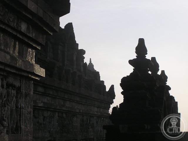
The approach through the park reveals Borobudur as a stepped hill of stone, the levels and profiles gradually clarifying as you approach. The base of the monument is approximately 123 × 123 metres; the stacked platforms rise in five rectangular terraces (the middle one set back slightly to accommodate the relief galleries) before transitioning to three circular terraces. The vertical profile traces a straight slope toward the circular terraces and the central stupa.
The relief galleries on the square terraces are designed to be walked clockwise on each level, the reliefs carved in such a way that they must be read while walking in this direction (the narrative faces the wall on your right). The 72 bell-shaped stupas on the circular terraces each contain a seated Buddha visible through the perforated stone lattice; the lattice creates a play of light and shadow on the figures inside. Sunrise from the summit, with Merapi on the eastern horizon, is the experience the temple builders intended: the highest point of the monument, exactly at sunrise on certain days of the year, catches the first light of the sun before the surrounding lowland plain is illuminated.
Practical information
- Location: near Magelang, 40 km north-west of Yogyakarta; direct bus services from Yogyakarta (Jombor bus terminal)
- Hours: daily 6 am–5 pm; sunrise tours (5 am) available from nearby hotels with advance booking
- Admission: foreigners IDR 450,000 (approximately USD 28); includes entry to Mendut and Pawon temples on the same axis
- Photography: permitted throughout; the sunrise tours (before 8 am) have dramatically better light and significantly fewer visitors than the midday peak
- Combination: Prambanan Hindu temple complex is 40 km east of Yogyakarta; the Borobudur–Prambanan combination is the classic Central Java heritage day
Getting there
Yogyakarta International Airport (YIA) is the nearest international gateway; direct flights from Singapore, Kuala Lumpur, and Jakarta. From Yogyakarta city: 1.5 hours by bus or car. Organised day trips from Yogyakarta are common. GPS: -7.6079, 110.2038.
Nearby
- Mendut Temple — the start of the sacred axis leading to Borobudur; 9th-century Buddhist temple with three remarkable interior Buddha statues; 3 km east; included in Borobudur ticket
- Prambanan — the 9th-century Hindu temple complex east of Yogyakarta; the Trimurti (Brahma, Vishnu, Shiva) temples are among the finest Hindu architecture in South-East Asia; UNESCO WHS; 40 km east
- Yogyakarta — the cultural capital of Java; the Sultan’s Palace (Kraton), Malioboro street, batik workshops, and the gateway to the volcanoes; 40 km south-east
- Mount Merapi — one of the most active volcanoes on earth; visible from Borobudur; guided tours to the rim from Yogyakarta
Sources
- Wikipedia, Borobudur, accessed June 2026
- Official site: borobudurpark.com
- UNESCO, Borobudur Temple Compounds, WHS reference 592, inscribed 1991
- Jan Fontein (ed.), The Sculpture of Indonesia, National Gallery of Art, Washington, 1990 — comprehensive study of the relief programme
Find it on the map
See this place and what’s around it →📷 Diventa un fotografo di Cultural Heritage Online
Condividi le tue foto dei luoghi: restano pubblicate con la tua firma come autore. Più vengono viste, più ti fai conoscere — e presto un concorso premierà le foto più apprezzate.
Accedi o registrati gratis per aggiungere una foto