Tikal — Guatemala
At dawn, the stone temples of Tikal emerge from the jungle canopy as the howler monkeys call — the tallest Maya temples at 70 metres, built in a city of 100,000 people that dominated the lowland Maya world for six centuries and then disappeared into the forest for a thousand years.
At a glance
Tikal is the largest excavated Maya site in Guatemala, located in the lowland tropical rainforest of the Petén department, in the northern part of the country. At its height during the Classic period (250–900 AD), Tikal was one of the most powerful Maya city-states, with a population estimated at 100,000–200,000 people in the greater metropolitan area and political influence extending across the Maya lowlands and into the Mexican highlands. The site contains over 3,000 separate structures across a 16 km² core area, including six monumental temple pyramids (the tallest, Temple IV, reaches 70 metres), royal palaces, ball courts, plazas, and extensive residential complexes. The city was abandoned around 900 AD, possibly due to a combination of drought, soil depletion, warfare, and political collapse; the jungle overgrew the buildings until 19th-century explorers began reporting the ruins. Tikal National Park was inscribed as a UNESCO World Heritage Site in 1979.
Key facts
- Period: occupied from c. 900 BC; major construction from c. 1 BC; peak power 200–900 AD; abandoned c. 900 AD
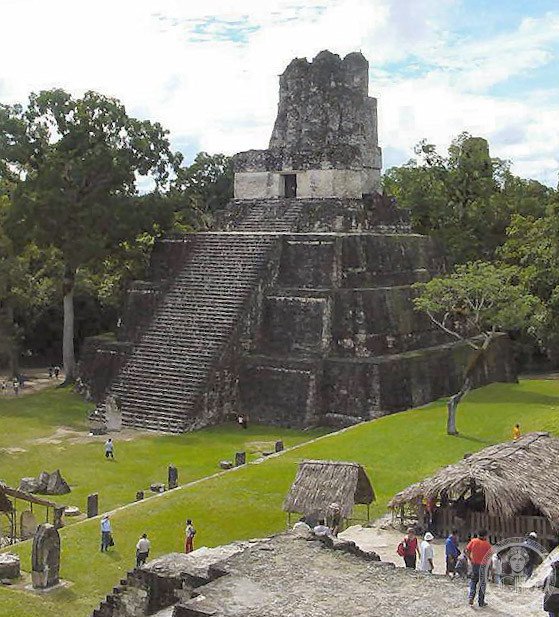
- Temples: six major temple pyramids; Temple I (Temple of the Great Jaguar, 47 m) and Temple II face each other across the Great Plaza; Temple IV (Temple of the Two-Headed Serpent, 70 m) is the tallest pre-Columbian structure in the Americas accessible to visitors
- Great Plaza: the site’s ceremonial heart; flanked by Temple I and Temple II; bordered by the North Acropolis (royal burials) and the Central Acropolis (royal palace complex)
- Ruler: Spearthrower Owl (Siyaj K’ahk’), a general from Teotihuacan, conquered Tikal in 378 AD, establishing the Teotihuacan-influenced dynasty that built the city’s major monuments
- Steles: Tikal has the largest concentration of carved steles of any Maya site; they record royal genealogies, conquests, and astronomical events in the Long Count calendar
- Heritage: UNESCO World Heritage Site, Tikal National Park, inscribed 1979
- GPS: 17.2220° N, 89.6237° W
History
Tikal was first occupied around 900 BC; the earliest substantial buildings date to the 3rd century BC. The city’s rise to regional prominence was accelerated by the arrival of Siyaj K’ahk’ (Spearthrower Owl), a war leader from Teotihuacan in central Mexico, who conquered Tikal in 378 AD and installed a new dynasty with close ties to the Teotihuacan empire. This connection gave Tikal access to the trade networks and prestige goods of central Mexico; the city’s art and architecture of the Early Classic period shows strong Teotihuacan influence in pottery styles, burial practices, and architectural forms.
The Late Classic period (600–800 AD) was Tikal’s architectural high point. The two rulers Siyaj Chan K’awiil II (Shield Skull) and Jasaw Chan K’awiil I (Ruler A) presided over the construction of the Great Plaza’s major monuments: Temple I was built by Ruler A (who won a decisive victory over the rival city of Calakmul in 695 AD) as his own mortuary monument; Temple II was possibly built for his queen. Their tombs, discovered in the 1950s–1960s, contained extraordinary jade mosaic masks, ceramics, and obsidian objects now in the National Museum of Archaeology and Ethnology in Guatemala City.
Tikal was abandoned around 900 AD; the last known dated monument is from 869 AD. The combination of factors that caused the Classic Maya collapse — prolonged drought, agricultural exhaustion, political fragmentation, and epidemic disease — are still debated; Tikal’s collapse may have been particularly related to drought and the severing of trade networks. The tropical rainforest grew over the buildings; by the time Modesto Méndez rediscovered the site in 1848, even the largest temples were buried under centuries of vegetation. American archaeologists from the University of Pennsylvania conducted the first major excavation from 1956 to 1970; Guatemalan and international archaeologists continue to work at the site.
What you see
The approach from the park entrance through the jungle takes 20–40 minutes on foot; the howler monkeys, toucans, and coatimundis in the canopy above are part of the experience. The clearing into the Great Plaza is abrupt: two stepped pyramids face each other across a flat expanse of stone, the jungle rising behind them on all sides. Temple I (47 metres) is the most photographed structure; its nine terraces, staircase, and three-roomed temple at the summit rise steeply above the plaza. Temple II (38 metres) is accessible and offers the most famous viewpoint — looking across the Great Plaza at Temple I with the trees framing the composition.
Temple IV, a 40-minute walk west through the jungle, is the tallest structure at 70 metres; wooden stairs allow visitors to climb to a platform above the jungle canopy from which the crowns of Temples I, II, and III are visible above the green expanse of the forest, surrounded by nothing but jungle. This view — the stone spires of a lost city rising above the rainforest — was used as the exterior of the rebel base in Star Wars: Episode IV — A New Hope (1977). The acoustic of Tikal’s plazas amplifies the howler monkeys to extraordinary volume at dawn; visiting for sunrise (which requires sleeping in the park or arriving very early) is the definitive Tikal experience.
Practical information
- Location: Petén department, Guatemala; 64 km north of Flores (1.5 hours by road)
- Hours: daily 6 am–5 pm; sunrise and sunset tours may extend these hours with a special permit
- Admission: GTQ 150 (approximately USD 20) for foreigners
- Sunrise visit: strongly recommended; requires staying at one of the jungle lodges inside the park (Jungle Lodge, Tikal Inn, Jaguar Inn) or arranging a 4 am departure from Flores; the mist in the Great Plaza at sunrise and the dawn calls of the howler monkeys are the definitive Tikal experience
- Guides: licensed guides available at the entrance; recommended for identifying wildlife and explaining the history of the rulers and their building programs
Getting there
Flores/Santa Elena airport (FRS) has direct flights from Guatemala City (45 minutes) and Cancun. From Flores, 64 km north to Tikal by road (1.5 hours by minibus). Guatemala City is 480 km south (8 hours by bus or 45 minutes by air). GPS: 17.2220, -89.6237.
Nearby
- Flores — the island town on Lake Petén Itzá; the Petén’s tourist hub; colonial churches, cayuco rides, and excellent birding at lake level; 64 km south
- Uaxactún — a smaller Maya site 25 km north of Tikal; the E-Group here (three small temples aligned to mark the solstices and equinoxes from a central pyramid) is the earliest known astronomical alignment in the Maya world
- Yaxhá — a Classic Maya site on a lake 65 km south-east of Tikal; significantly less crowded; Tikal-era temples rising above the lake; sunrise views of the water
- Belize — 100 km east of Flores; the Actun Tunichil Muknal cave (ATM) holds complete Maya skeletal remains in its deepest chambers; one of the most extraordinary archaeological experiences in Mesoamerica
Sources
- Wikipedia, Tikal, accessed June 2026
- Instituto de Antropología e Historia Guatemala (IDAEH): mcd.gob.gt
- UNESCO, Tikal National Park, WHS reference 64, inscribed 1979
- William R. Coe, Tikal: A Handbook of the Ancient Maya Ruins, University Museum of the University of Pennsylvania, 1967
Find it on the map
See this place and what’s around it →📷 Diventa un fotografo di Cultural Heritage Online
Condividi le tue foto dei luoghi: restano pubblicate con la tua firma come autore. Più vengono viste, più ti fai conoscere — e presto un concorso premierà le foto più apprezzate.
Accedi o registrati gratis per aggiungere una foto