St Kilda (sito misto): l’arcipelago delle aquile e dei puffini evacuato nel 1930, l’isola più remota della Gran Bretagna
Nell’Oceano Atlantico del Nord, a 64 km ad ovest delle Ebridi Esterne scozzesi, l’arcipelago di St Kilda è il luogo più isolato della Gran Bretagna: un pugno di isole basaltiche con falesie tra le più alte d’Europa (426 m), abitate ininterrottamente per 4.000 anni. Il 29 agosto 1930, gli ultimi 36 abitanti firmarono una petizione e furono evacuati dalla terraferma — la comunità più remota e autarchica d’Europa cessò di esistere in un giorno. Oggi St Kilda è una delle più importanti colonie di uccelli marini del mondo e un Patrimonio UNESCO triplo (naturale 1986, culturale 2004, biologico 2005).
At a glance
St Kilda is an archipelago of four islands (Hirta, Soay, Boreray, Dun) and several sea stacks in the North Atlantic, 64 km west of the Outer Hebrides, Scotland, UK. It is the remotest part of the British Isles. UNESCO first inscribed St Kilda in 1986 (ref. 387) as a natural site for its extraordinary seabird colonies (over 1 million birds, including the world’s largest gannet colony on Boreray), and extended the inscription in 2004/2005 to include its outstanding cultural and landscape values. St Kilda was continuously inhabited from the Bronze Age until 1930, when the last 36 residents voluntarily evacuated. It preserves over 1,200 stone structures (cleits — unique stone food stores) and an abandoned village.
Key facts
- UNESCO: Natural Heritage 1986; extended to Mixed Heritage 2004/2005 (St Kilda, ref. 387)
- Location: 64 km west of the Outer Hebrides; the most remote part of the British Isles
- Highest sea cliff: Conachair, Hirta, 426 m — one of the highest sea cliffs in the UK
- Gannet colony: Boreray and its stacks hold the world’s largest northern gannet colony (60,000+ pairs)
- Puffins: Hirta hosts over 130,000 puffin pairs; also Britain’s largest colony of Leach’s storm petrels
- Evacuation: 29 August 1930; the last 36 residents requested and received evacuation to mainland Scotland
History
Human settlement of St Kilda dates to at least 2000 BC (Bronze Age). Throughout its long history, the St Kildans developed a unique culture adapted to extreme isolation: they climbed the near-vertical sea cliffs bare-handed and in leather shoes to harvest gannets and fulmars (their primary food source), stored provisions in thousands of stone cleits (ventilated dry-stone chambers), paid rent to MacLeod of Dunvegan in feathers and oil, and had no currency. Their language was a distinct form of Scots Gaelic.
Contact with the outside world increased through the 19th century, bringing both benefits (medical care, Christianity, occasional tourism) and disruption. Epidemics killed large numbers; a particularly devastating winter in 1929–30, when the island was cut off for months and an appendicitis case could not be treated, persuaded the remaining community that survival was impossible. On 29 August 1930, the last 36 St Kildans were evacuated; they were resettled on the Scottish mainland. The islands were later owned by the National Trust for Scotland (from 1957) and a military radar station was built on Hirta in the 1950s, which remains today.
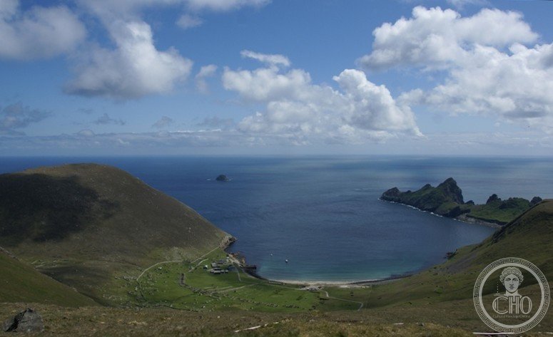
What you see
Village Bay on Hirta is a crescent of ruined 19th-century stone cottages and the earlier remains of the blackhouse village behind them. Over 1,200 cleits (unique to St Kilda) dot the hillsides — these domed stone structures with turf roofs were used to store birds, eggs, peat and fuel. The sea stacks of Boreray, Stac an Armin and Stac Lee are covered in thousands of breeding gannets and rise dramatically from the Atlantic.
The wildlife is extraordinary: over a million seabirds breed here, including 130,000+ puffin pairs, thousands of gannets, fulmars, razorbills and guillemots. The endemic St Kilda field mouse and Soay sheep — a primitive prehistoric breed descended from the archipelago’s original stock — roam freely.
Practical information
- Access: day cruises from Leverburgh (Harris) and Uig (Skye) in summer; no regular ferry; crossing 3–4 hrs each way in good weather
- Weather: extreme; the island can be inaccessible for weeks; visits only possible May–September
- Stay: limited camping permitted on Hirta (permit required from NTS); the NTS volunteer camp has accommodation
- NTS: National Trust for Scotland manages the island; ranger station open in summer
Getting there
Board a cruise from Leverburgh (South Harris) or Uig (Skye) to St Kilda; multiple operators run summer day trips (weather permitting). The sea crossing takes 3–4 hrs. Most visits are day trips; overnight stays require NTS permission. GPS: 57.82° N, 8.59° W.
Nearby
- Outer Hebrides — the island chain with Harris Tweed, ancient standing stones (Callanish) and spectacular beaches
- Skye — the most dramatic of the Inner Hebrides, with the Cuillins and Dunvegan Castle
- Callanish Standing Stones (Calanais) — the Lewis stone circle, older than Stonehenge, 80 km east
Sources
- UNESCO World Heritage Centre — “St Kilda” (ref. 387)
- Encyclopaedia Britannica — St Kilda (island group)
- National Trust for Scotland — St Kilda heritage and visitor information
Find it on the map
See this place and what’s around it →📷 Diventa un fotografo di Cultural Heritage Online
Condividi le tue foto dei luoghi: restano pubblicate con la tua firma come autore. Più vengono viste, più ti fai conoscere — e presto un concorso premierà le foto più apprezzate.
Accedi o registrati gratis per aggiungere una foto