Aasivissuit–Nipisat (4.200 anni): il paesaggio della caccia Inuit in Groenlandia
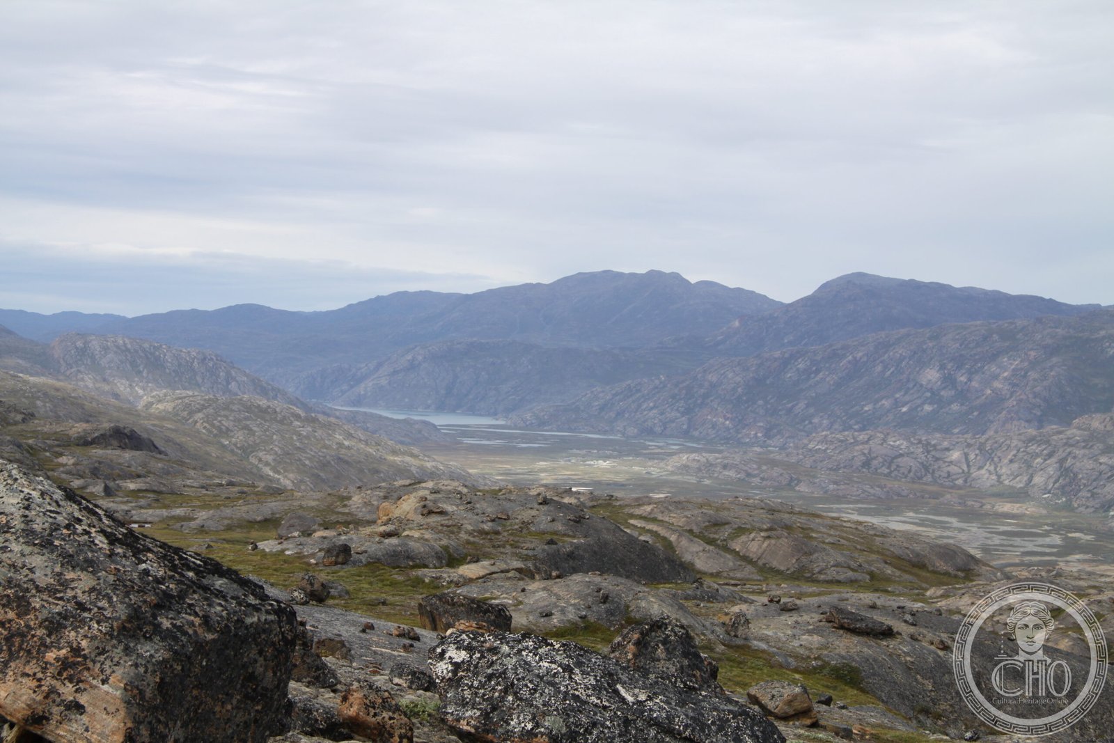
Tra la costa occidentale della Groenlandia e le terre interne, il sito UNESCO Aasivissuit–Nipisat conserva 4.200 anni di storia umana su uno dei paesaggi naturali più integri dell’Artico. Le sue tundre percorse ogni anno dalla migrazione delle renne selvatiche (caribù) sono state il cuore del ciclo di vita Inuit — caccia estiva all’interno, pesca invernale sul ghiaccio costiero — dai tempi dei Palaeo-Eschimesi fino ai cacciatori Inuit moderni. Un’area di 33.000 kmq dove la natura e la cultura umana si sono co-evolute per millenni. Patrimonio UNESCO dal 2018.
At a glance
Aasivissuit–Nipisat (“where there are many caribou”–“abundant fish” in Greenlandic Inuit) is a UNESCO World Heritage serial site (2018, ref. 1557) in West Greenland, between the coast at Nipisat Island (near Sisimiut) and the inland area of Aasivissuit. It covers 33,395 km² and documents the longest continuous human habitation in Greenland: 4,200 years of Palaeo-Eskimo (Saqqaq and Dorset cultures) and Inuit occupation, centred on seasonal caribou hunting routes and sea-mammal fishing. The landscape is virtually unchanged from the times of its earliest inhabitants.
Key facts
- UNESCO: World Heritage since 2018 (Aasivissuit–Nipisat, ref. 1557)
- Area: 33,395 km² — one of the largest cultural landscapes in the UNESCO system
- Human history: 4,200 years of continuous use: Saqqaq (2200 BC), Dorset and Thule/Inuit cultures
- Caribou: the landscape is defined by the annual migration of West Greenland caribou (Rangifer tarandus groenlandicus)
- Languages: Inuit (Greenlandic/Kalaallisut) place names preserve centuries of ecological knowledge
- Nearest town: Sisimiut (pop. 5,500) — the second-largest town in Greenland, at the coast
History
The oldest known occupants of the Aasivissuit–Nipisat area are the Saqqaq culture (c. 2200 BC), Palaeo-Eskimos who hunted caribou and sea mammals and left tent ring foundations and lithic artefacts across the tundra. The subsequent Dorset culture (c. 800 BC–1000 AD) is represented by larger settlements at Nipisat Island. Around 1000–1400 AD, the Thule people — ancestors of the modern Greenlandic Inuit — migrated from Alaska via Arctic Canada and settled the coast. Their descendants continue to live in the area today, in the town of Sisimiut.
The Inuit seasonal cycle that the site embodies — summer caribou hunts in the interior, winter seal and narwhal hunting on the sea ice — was maintained virtually unchanged until the 20th century. Danish colonisation from the 18th century introduced Christianity and trade goods but did not fundamentally alter the subsistence pattern until after World War II. The UNESCO inscription in 2018 recognised both the natural landscape and its deep cultural significance to Greenlandic Inuit identity.
What you see
The landscape is Arctic tundra: rolling hills of heather, sedge and dwarf birch, threaded by clear rivers and dotted with lakes. In summer (June–August), wildflowers cover the hillsides and the sun barely sets. Archaeological remains — tent rings, middens, stone fox traps — are often visible to the trained eye but unobtrusive in the vast tundra. Caribou herds crossing the valleys, Arctic fox, ptarmigan and musk ox complete the wildlife picture. The coast at Nipisat is a mosaic of fjords, islands and sea ice (in winter).
The Sisimiut Museum, at the gateway to the site, provides the essential cultural context before venturing into the landscape.
Practical information
- Base: Sisimiut (accessible by Air Greenland from Nuuk or Kangerlussuaq airport)
- Access to interior: guided hiking and dog-sled expeditions from Sisimiut; the Arctic Circle Trail (165 km) crosses the edge of the heritage area
- Arctic Circle Trail: a 7–10 day route from Sisimiut to Kangerlussuaq through pristine tundra; well-marked, huts available
- Best time: late June–August (midnight sun, accessible tundra); March (dog-sled on frozen lakes)
Getting there
Fly Air Greenland to Sisimiut from Nuuk (30 min) or connect via Kangerlussuaq. The heritage area begins at the edge of town. Alternatively, take the ferry Arctic Umiaq from Nuuk to Sisimiut (12 hrs, spectacular fjord scenery). GPS (Aasivissuit inland area): 67.06° N, 51.43° W.
Nearby
- Kangerlussuaq — the main hub airport for Greenland, at the head of a 170 km fjord; musk ox visible from the road
- Ilulissat Icefjord (UNESCO) — the world-famous ice fjord, 200 km north by air
- Nuuk — Greenland’s capital, with the Greenland National Museum (outstanding Inuit collection), 350 km south
Sources
- UNESCO World Heritage Centre — “Aasivissuit–Nipisat, Inuit Hunting Ground” (ref. 1557)
- Greenland National Museum — Inuit cultural history documentation
- Encyclopaedia Britannica — Greenland / Inuit peoples
Find it on the map
See this place and what’s around it →📷 Diventa un fotografo di Cultural Heritage Online
Condividi le tue foto dei luoghi: restano pubblicate con la tua firma come autore. Più vengono viste, più ti fai conoscere — e presto un concorso premierà le foto più apprezzate.
Accedi o registrati gratis per aggiungere una foto