Palmanova — la Città Stellata Veneziana (1593): la Fortezza Ideale del Rinascimento con Nove Bastioni e il Piano Radiocentrico che Non Fu Mai Modificato (UNESCO 2017)
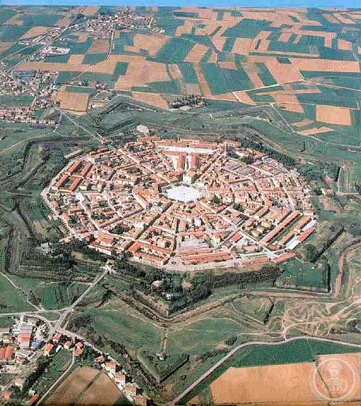
Palmanova — founded on 7 October 1593 by the Republic of Venice on an empty field on the eastern frontier of the Venetian state, on the anniversary of the Battle of Lepanto (1571) — is the only planned fortified city in Italy from the Renaissance period that survives substantially intact in its original 9-pointed star plan: nine bastions, nine main streets converging radially on the central hexagonal piazza, three gates (each facing a different direction in the approach roads), all built at the same time and never fundamentally altered by subsequent centuries of occupation.
At a glance
Palmanova (province of Udine, Friuli-Venezia Giulia) is one of six components of the UNESCO serial property “Venetian Works of Defence Between the 16th and 17th Centuries: Stato da Terra — Western Stato da Mar” (ref. 1533, inscribed 2017), covering Renaissance-period Venetian fortifications in Italy, Croatia, and Montenegro. The inscription recognizes the architectural innovation of the bastion system (the angled projecting fortification designed to eliminate the blind angles of medieval towers and to provide interlocking fields of fire for cannon) as it was developed by Venetian military engineers in the 16th century and applied across the Republic's territories. Palmanova is the most complete surviving example of a planned bastion fortification city in Europe: it is the only place where the full circuit of bastions, curtain walls, and the radial urban plan they were designed to defend are all preserved at full scale and largely unaltered since the early 17th century.
Key facts
- Foundation (7 October 1593): The Republic of Venice decided to build a new fortified city on the eastern frontier of the Terraferma (the mainland territories of the Venetian Republic) after the Ottoman threat following Lepanto (1571) and the persistent instability of the Friulian border. The site (at the confluence of the Natisone and Isonzo river valleys, on a flat plain) was chosen specifically because it had no prior occupation — the ideal was to build a fortification without the compromises imposed by an existing urban fabric. The date chosen for the foundation ceremony (7 October, the anniversary of the Battle of Lepanto) was a deliberate symbolic choice. The attribution of the design to Vincenzo Scamozzi (the Venetian architect who succeeded Palladio) is not definitively documented but is probable; Giulio Savorgnan (the Venetian military engineer) was responsible for the fortification planning
- The plan: A regular 9-pointed star (the nonagon form with 9 bastions at the vertices and 9 curtain walls between them); inside the fortification, 9 radial streets converge from the 3 gates and 6 lesser points to the central hexagonal piazza (Piazza Grande, now Piazza Maggiore); the blocks between the radial streets and the concentric ring road are uniformly subdivided into building plots of fixed dimensions; the plan allows direct artillery fire from every bastion to the two adjacent bastions, eliminating blind angles completely
- Three construction phases: First circle (bastions 1593-1600, originally 9 bastions with triangular projections called ravelins); second circle (1606-1623, adding a second ring of earthen bastions and a ditch — this phase was completed by the Venetians); third circle (1806-1813, added by Napoleon who occupied Palmanova from 1806 to 1814 and expanded the outer ring to a 9-pointed star with 3 additional outer bastions)
- UNESCO: 2017, ref. 1533
- GPS: 45.9060, 13.3120 — Google Maps (Piazza Maggiore)
History
Palmanova was settled slowly after its foundation: the incentives offered to settlers (free land plots, tax exemptions) attracted some colonists but the city never reached the planned population; the 9-pointed plan — designed for a population of 30,000 — never housed more than 5,000-6,000 people in the Venetian period. The city served primarily as a military garrison and trading post for the eastern frontier. After the fall of the Venetian Republic to Napoleon (1797), Palmanova passed to France (1806), then to Austria (1815), then to Italy (1866). During World War I, Palmanova was a key point in the Italian defensive line on the Isonzo front; the fortifications were used as military barracks through 1945. The intact survival of the fortifications is due to the city's relative military importance (it was garrisoned continuously and therefore maintained) and to the lack of economic pressure for urban renewal (the small city never generated the commercial wealth that would have driven demolition of the walls).
What you see
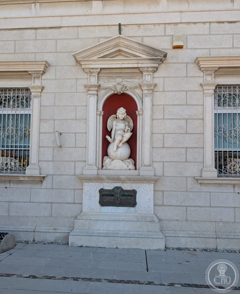
The visit to Palmanova proceeds on two levels: the city plan (best appreciated from the air or from the belvedere at the top of one of the bastions) and the street level (the radial streets, the Piazza Maggiore, and the three monumental gates). The Piazza Maggiore (the central hexagonal piazza, 80m across) has the 17th-century cathedral (Duomo di Palmanova, with the octagonal Oratorio della Madonna, 1603) on the northern side and the Palazzo del Provveditore Generale (the Venetian governor's palace, 1598) on the south; the hexagonal plan of the piazza mirrors the hexagonal form of the bastions at the vertices of the outer wall. The three gates (Porta Aquileia, Porta Udine, Porta Cividale) each face one of the three access roads and have the same design: a straight passage under a semicircular barrel vault, flanked by pilasters, with the Lion of Saint Mark (the Venetian symbol) above the keystone. Walking from any gate to the piazza along the radial street takes approximately 5-7 minutes; the radial perspective (the street slightly narrowing towards the centre, creating an exaggerated convergence) is the most immediately striking spatial experience of the city. The bastions are accessible (some offer internal casemates open for visits; the Rivellino di Porta Aquileia has a museum of the fortification system). The Museo Civico (Piazza Grande 1) has models of the fortification system and historical documents.
Gallery
Practical information
- Palmanova: Free to walk at all times. The bastions and gates are always accessible from the exterior. Some interior fortification structures (casemates, underground passages) are open for guided visits on weekends (check with the Infopoint Palmanova, Borgo Cividale 1).
- Museo Civico: Piazza Grande 1; open Friday-Sunday 10:00-12:30 and 15:00-18:30; admission ~€4.
- Helicopter/drone views: The 9-pointed star plan is only fully legible from above; free aerial imagery (Google Maps satellite view) gives the clearest impression of the complete fortification plan. Drone use requires permits as Palmanova is a sensitive site.
- Season: Year-round. Palmanova hosts a historical pageant (Palio di Palmanova) with Renaissance costumes and crossbow competitions, typically in September. The Sagra del Prosciutto di San Daniele is held nearby (San Daniele del Friuli, 30 km north).
Getting there
Piazza Maggiore, Palmanova (UD), Friuli-Venezia Giulia. GPS 45.9060, 13.3120. By train: no direct rail service to Palmanova; nearest station: Aquileia-Belvedere (Udine-Cervignano line, 8 km south; then taxi). By bus: SAF bus from Udine (25 km, 35 min, 5-6 services/day). By car: from Udine, A23 then SS352 south (25 km, 25 min); from Venice, A4 then A23 north to Palmanova exit (135 km, 1h30).
Nearby
- Aquileia — 12 km south; the most important Roman and early Christian city in northeastern Italy; UNESCO 1998 (ref.825); the Basilica di Aquileia has the largest surviving early Christian mosaic floor in the world (760 m², 4th century CE); the Museo Nazionale Archeologico has the finest Roman sculpture collection in northern Italy
- Cividale del Friuli — 30 km north-east; the Tempietto Longobardo (8th century, UNESCO 2011 ref.1318; CHO card: Cividale del Friuli UNESCO 2011) and the Altar of Ratchis (734-744 CE, finest Lombard sculpture)
- Grado e Laguna di Marano — 20 km south; the Venetian-Byzantine basilica of Sant'Eufemia (Grado, 6th century; Mosaic floors); the lagoon of Marano with its fishing villages and migratory bird habitat
Sources
- UNESCO: whc.unesco.org/en/list/1533
- Wikipedia EN: Palmanova
- Manno, Antonio: Il politecnico (historical plans of Palmanova), Electa, 1992
- Comune di Palmanova: palmanova.it
Find it on the map
See this place and what’s around it →📷 Diventa un fotografo di Cultural Heritage Online
Condividi le tue foto dei luoghi: restano pubblicate con la tua firma come autore. Più vengono viste, più ti fai conoscere — e presto un concorso premierà le foto più apprezzate.
Accedi o registrati gratis per aggiungere una foto