Baia di Ieranto
A sheltered limestone cove on the southern tip of the Sorrentine Peninsula, accessible only on foot and preserved as an FAI marine reserve whose waters rank among the clearest and least disturbed on the Italian Tyrrhenian coast.
At a glance
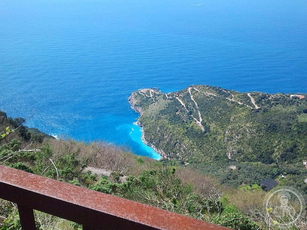
Baia di Ieranto cuts into the limestone cliffs at the southwestern extremity of the Sorrentine Peninsula, facing the island of Capri across a 5-kilometre channel. The bay was the site of industrial extraction — a tuff quarry operated here until the 1960s — before the FAI acquired the land in 1997 and began ecological restoration. No road reaches the bay; access is by a 40-minute path from the village of Nerano, which effectively limits visitor numbers and has allowed the underwater habitat (Posidonia meadows, gorgonian fans) to recover substantially. The FAI manages the site in partnership with the Campania Region and the Punta Campanella Marine Reserve, maintaining the path, the small beach, and the former quarry structures.
Key facts
- Area: Approximately 30 hectares (land) + marine buffer zone
- FAI acquisition: 1997
- Access: Foot only — 40-minute path from Nerano village (no road)
- Marine reserve: Zone A (Punta Campanella), highest protection level
- Depth: Up to 30 metres in the bay; Posidonia habitat from 5–20 m
- Historical use: Tuff quarry until 1960s
- GPS: 40.5831, 14.3317 — Google Maps
History
The Ieranto cove has been inhabited since antiquity: Roman fish pools (piscinae) carved into the rock at the waterline are still visible at low tide on the eastern headland, and ancient mooring rings remain fixed in the limestone above the current beach. The bay’s name may derive from Latin hierantum (a sacred or forbidden space), suggesting a cult site or augury station on the promontory.
Industrial use began in the twentieth century when a company began quarrying the grey tuff stone from the cliff face above the beach, loading barges directly from a jetty. The operation continued until the early 1960s; traces of the extraction — scarped cliff faces, industrial ramps — remain visible as a geological signature of the industrial period. After extraction ceased, the land passed through several owners before the FAI purchased it in 1997 as part of its coastal heritage programme.
Restoration focused on removing invasive species, reconsolidating the cliff paths, and allowing the marine habitat to recover without active intervention. Snorkelling surveys conducted since 2005 document the return of grouper, sea bream, and the recolonization of bare rock by red alga and gorgonians below 15 metres.
What you see
The path from Nerano descends through terraced lemon groves and Mediterranean maquis — rosemary, lentisk, rock rose — before the cliff drop reveals the bay. The first view from the headland is the defining moment: the water is jade-green close to the shore, deepening to cobalt in the channel, and Capri sits directly opposite at the horizon, close enough to read the limestone profile of the Faraglioni. The bay’s east wall still bears the vertical scars of quarrying; the west wall is natural, undercut by wave action into a series of small grottos accessible by swimming.
The beach is gravel and fine pebble, about 80 metres wide. At low tide the Roman piscinae emerge from the water at the north-east corner — rectangular tanks about 1.5 × 2.5 metres, cut precisely into the bedrock. The water clarity in summer, with visibility to 10–12 metres, makes free-diving into the Posidonia meadow between the beach and the first drop-off one of the few experiences on the Sorrentine coast that still feels genuinely wild.
Gallery
Practical information
- Access path: From Nerano village parking area; 40-minute descent (1.5 km); return is uphill — allow 55 minutes. Sturdy footwear essential; path is rocky.
- Facilities: None at the bay (no bar, WC, or shade structures). Bring water and food.
- Swimming: Open during FAI operating season; boat anchor prohibited in zone A.
- Best months: June and September for calm water and fewer visitors.
- FAI rangers: Present from June to mid-September, can assist with path conditions.
Getting there
Drive or take the SITA bus from Sorrento (direction Meta–Massa Lubrense) to Nerano; parking at the village square (very limited) or on the approach road. From Naples: A3 motorway to Castellammare di Stabia, then SS145 Sorrentina to Sorrento and onward via Sant’Agata sui Due Golfi to Nerano (approximately 1h30 from Naples). Ferry from Sorrento or Positano to Marina del Cantone (adjacent cove) in summer, then 15-minute walk to the path head.
Nearby
- Marina del Cantone — adjacent cove with restaurants and diving centre, 15 min walk
- Punta Campanella — southernmost point of Sorrentine Peninsula, lighthouse and Greek-era sanctuary, 3 km by coastal path
- Capri — ferry from Marina del Cantone or Sorrento (30 min); Grotta Azzurra and Villa Jovis
Sources
- FAI – Fondo Ambiente Italiano: fondoambiente.it/luoghi/baia-di-ieranto
- Wikipedia IT: Baia di Ieranto
- Area Marina Protetta Punta Campanella: puntacampanella.org
- Napolitano, F.: Coste della Campania, Touring Club Italiano, 2019
Find it on the map
See this place and what’s around it →📷 Diventa un fotografo di Cultural Heritage Online
Condividi le tue foto dei luoghi: restano pubblicate con la tua firma come autore. Più vengono viste, più ti fai conoscere — e presto un concorso premierà le foto più apprezzate.
Accedi o registrati gratis per aggiungere una foto