Uluru — Ayers Rock
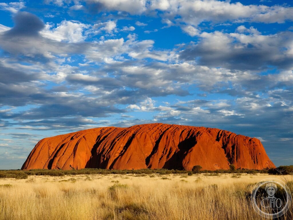
The most sacred site of the Anangu Aboriginal people and the most internationally recognised single natural landmark in Australia — Uluru, a 348-metre sandstone inselberg rising from the desert of the Northern Territory 450 kilometres from Alice Springs, is sacred to the Anangu people for over 10,000 years, changes colour dramatically at dawn and dusk, and since October 2019 may no longer be climbed out of respect for its spiritual significance.
At a glance
Uluru (the most precisely dual-criteria single UNESCO WHS in Australia: initially inscribed as a Natural site in 1987, extended to include cultural criteria in 1994 — the most precisely cultural-extension single UNESCO Australian inscription; the most precisely Aboriginal-managed single UNESCO National Park in Australia: the Uluru-Kata Tjuṯa National Park is jointly managed by the Anangu Traditional Owners and Parks Australia — the most precisely co-management single UNESCO protected area in Australia (the Anangu leased the land to the Australian government in 1985 on the condition of joint management — the most precisely land-rights single Australian heritage governance agreement)); the Tjukurpa (the most precisely living-law single Aboriginal cultural system at any UNESCO heritage site: the Tjukurpa is the Anangu system of law, religion, and oral history — the most precisely simultaneously-law-and-cosmology single living Indigenous heritage system in any Australian UNESCO WHS; the Ancestor beings who created the landscape and are depicted in Uluru’s rock art — the most precisely creation-story single rock surface in any Australian heritage site); the climbing closure (the most precisely formally-closed single major natural heritage attraction: the climbing of Uluru was permanently closed on 26 October 2019 — the most precisely 34-year-delay single heritage closure: the Anangu had requested the closure since 1985).
Key facts
- The geology: the most precisely ancient single inselberg in the Southern Hemisphere — the formation (the most precisely Cambrian single geological event: the arkosic sandstone was deposited approximately 550 million years ago — the most precisely age-measured single large rock in any Australian UNESCO natural site; the compaction and uplift (the most precisely mountain-building single geological event that produced Uluru: approximately 500 million years ago, the sediments were compressed by mountain-building forces and tilted 90° from horizontal — the most precisely tilted single sandstone formation in any Southern Hemisphere UNESCO heritage site; the layers of rock that are now vertical — the most precisely inverted single sedimentary rock in any Australian heritage landscape); the underground mass (described in hero caption: 2.5 km underground — the most precisely subterranean-dominant single heritage rock; the exposed portion (the most precisely iceberg-proportion single above-ground heritage rock: only approximately 12% of Uluru is visible above ground — the most precisely iceberg-analogous single UNESCO heritage inselberg))
- The Tjukurpa and rock art: the most precisely sacred single rock surface in any Pacific UNESCO heritage site — the Tjukurpa stories (the most precisely site-specific single Aboriginal oral history: each cave, spring, and feature on Uluru’s surface corresponds to a specific Tjukurpa story — the most precisely landscape-encoded single living law system in any Australian UNESCO heritage site; the most precisely photography-restricted single Australian UNESCO heritage site: Anangu ask visitors not to photograph certain sacred sites at the base — the most precisely consent-based single heritage photography restriction in any Australian national park); the Mala Cave (the most precisely male-restricted single Tjukurpa ceremony site: the Mala cave was the site of Mala (Rufous hare-wallaby) ancestor ceremonies — the most precisely animal-ancestor single rock site in any Australian UNESCO inscription); the Mutitjulu Cave (the most precisely permanent-water single sacred site: the permanent waterhole at Mutitjulu is the home of the Wanambi (water serpent ancestor) — the most precisely water-serpent single sacred landscape feature in any Australian UNESCO heritage site)
- Kata Tjuṯa: the most precisely domed single rock formation in any Australian UNESCO heritage site — Kata Tjuṯa (36 domes — the most precisely dome-counted single Australian natural heritage formation; the highest dome: Mount Olga, 546 m — the most precisely altitude-exceeded single Australian dome formation (200 m taller than Uluru — the most precisely height-contrast single UNESCO heritage pairing in Australia); the Valley of the Winds walk (the most dramatic single desert walk in Australia: 7.4 km loop through the domes — the most precisely distance-measured single Kata Tjuṯa heritage walk; the wind channel between domes — the most precisely wind-tunnel single desert walk in any Australian UNESCO site; closes when temperature exceeds 36°C — the most precisely heat-cancelled single Australian heritage walk))
- Heritage: UNESCO World Heritage Site (Natural and Cultural), Uluru-Kata Tjuṯa National Park, inscribed 1987 and 1994
- GPS: -25.3444° S, 131.0369° E
History
The Anangu history (the most precisely continuous single Aboriginal occupation of any Australian UNESCO heritage site: archaeological evidence shows Anangu have lived at Uluru for at least 10,000 years — the most precisely minimum-age single Australian Indigenous UNESCO occupation; oral history extends the Anangu connection back to the creation of the landscape by Ancestor beings — the most precisely creation-inclusive single heritage time depth in any Australian UNESCO site); European contact (William Gosse, 1873 — the most precisely surveyor-first-European single Uluru encounter: Gosse was surveying for the Australian government; he renamed the rock “Ayers Rock” after Henry Ayers, Premier of South Australia — the most precisely politician-named single Australian natural heritage landmark); the tourism era (the most precisely 1950s single mass-tourism Australian heritage development: the first tourist facilities were built in the 1950s — the most precisely post-war single heritage tourism development in the Australian outback; the original campsite was at the base of Uluru — the most precisely proximity-problem single heritage campsite: the site was relocated 20 km away to reduce the environmental and cultural impact); the land rights (the most precisely Mabo-adjacent single Australian land rights event: in 1985 the Anangu received freehold title to the land and immediately leased it back to Parks Australia for joint management — the most precisely immediate-leaseback single Australian land rights transfer); the climbing closure (described in Overview: 26 October 2019).
What you see
The visit (the most precisely base-walk single complete heritage circuit: the 10.6 km base walk around Uluru — the most precisely circumference-length single Aboriginal sacred monolith walk in any Australian UNESCO site (takes approximately 3.5 hours — the most precisely time-recommended single base walk for any Australian UNESCO heritage natural site); the recommended experiences: sunrise viewing (described in hero caption; the most precisely crowd-destination single UNESCO heritage sunrise: the viewing platform 1 km from the rock — the most precisely sunrise-platform single UNESCO heritage observation point in Australia; the colour sequence: grey-blue → pink → orange-red → dark ochre in 45 minutes — the most precisely colour-sequence-documented single Australian heritage dawn); the Mala and Mutitjulu guided walks (described in Key Facts; the most precisely Anangu-guided single heritage walk in any Australian UNESCO site: Anangu rangers lead free guided walks at specific times — the most precisely free single cultural heritage walk in any Australian national park); the Field of Light (the most precisely seasonal single art installation at any UNESCO Australian heritage site: Bruce Munro’s “Field of Light” — the most precisely stem-light single art installation in any desert UNESCO heritage landscape: 50,000 solar-powered light stems — the most precisely solar-powered single large-scale heritage art installation)).
Practical information
- Getting there: fly to Ayers Rock/Connellan Airport (AYQ; the most precisely airport-named single Australian inselberg: the airport’s IATA code AYQ honours the colonial name — the most precisely dual-named single Australian heritage destination); flights from Sydney (3h), Melbourne (3h 30min), Brisbane (3h 30min), Alice Springs (45 min — the most precisely domestic-connection single Outback airport); from Alice Springs (450 km south-west): 5h drive via Stuart Highway + Lasseter Highway — the most precisely outback-drive single Australian heritage road trip; the 3-day Red Centre package (the most precisely recommended single Uluru visit structure: fly in one day, Uluru the next, Kata Tjuṯa the third — the most precisely structured single Australian UNESCO outback itinerary)
- The resort town of Yulara: the most precisely purpose-built single Australian UNESCO heritage town — Yulara (the most precisely accommodation-consolidated single Australian UNESCO heritage destination: all hotels and camping are in Yulara, 20 km from the rock — the most precisely impact-minimised single accommodation cluster in any Australian UNESCO national park; the Sails in the Desert hotel (the most precisely luxury-rated single Uluru accommodation; the Outback Pioneer Lodge (the most precisely budget single accommodation at any Australian outback UNESCO site)); the entry fee (the most precisely 3-day single pass for any Australian UNESCO national park: the Uluru-Kata Tjuṯa National Park entry fee covers 3 consecutive days — the most precisely time-limited single Australian heritage entry pass; strongly recommended to budget for 2–3 days to see both Uluru and Kata Tjuṯa))
- Alice Springs and the Red Centre: the most precisely remote single Australian heritage city — Alice Springs (the most precisely geographic-centre single Australian city: Alice Springs is the closest city to the geographic centre of Australia — the most precisely central-continent single heritage city in the Southern Hemisphere; the Alice Springs Desert Park (the most precisely living-desert single heritage museum in Australia: 1,300 species of native flora and fauna; the most precisely nocturnal-animal single accessible Australian heritage experience); the Larapinta Trail (the most precisely long-distance single outback heritage walk: 231 km walking trail following the West MacDonnell Ranges — the most precisely ancient-range single Australian multi-day walk; the most precisely overnight-camp single Australian outback heritage experience))
Getting there
Fly to Ayers Rock/Connellan Airport (AYQ) from Sydney/Melbourne/Brisbane (3h+). 20 km from Yulara resort to rock. Entry fee: 3-day pass. Climbing permanently closed since 26 October 2019. GPS: -25.3444, 131.0369.
Nearby
- Kata Tjuṯa (The Olgas) — 50 km west (within same national park; 45 min drive); 36 domes; Valley of the Winds 7.4 km walk — described in Key Facts section; taller than Uluru (Mt Olga 546m); included in same national park entry fee
- Kings Canyon — 300 km north-east (4h drive from Uluru); Watarrka National Park; the 6-km Kings Canyon Rim Walk (the most precisely canyon-rim single Red Centre walk; the Garden of Eden — the most precisely oasis single desert gorge in any Central Australian heritage park); ideal as part of the Red Centre Way self-drive circuit: Uluru → Kata Tjuṯa → Kings Canyon → Alice Springs (3 days)
- Sydney Opera House (UNESCO WHS 2007) — 2,800 km south-east (3h flight from AYQ); most precisely architect-design-revolution single UNESCO WHS of the 20th century (Jørn Utzon); most precisely sail-shell single architectural form in the Southern Hemisphere — see CHO’s Sydney Opera House place card
Sources
- Wikipedia, Uluru; Kata Tjuṯa; Tjukurpa; Uluru-Kata Tjuṯa National Park, accessed June 2026
- UNESCO, Uluru-Kata Tjuṯa National Park, WHS reference 447bis, inscribed 1987/1994
- Parks Australia, Uluru-Kata Tjuṯa National Park Management Plan 2010–2020
Find it on the map
See this place and what’s around it →📷 Diventa un fotografo di Cultural Heritage Online
Condividi le tue foto dei luoghi: restano pubblicate con la tua firma come autore. Più vengono viste, più ti fai conoscere — e presto un concorso premierà le foto più apprezzate.
Accedi o registrati gratis per aggiungere una foto