Yosemite National Park
The most influential national park in history and the landscape that inspired the entire American conservation movement — Yosemite National Park, in the Sierra Nevada of California, preserves the incomparable Yosemite Valley, a glacier-carved granite chasm of vertical walls and thundering waterfalls that has transfixed artists, philosophers, and climbers since it became accessible to visitors in 1855.
At a glance
Yosemite National Park (UNESCO WHS 1984; established as a national park in 1890 — the 3rd US national park (after Yellowstone and Sequoia); total area: 3,081 km² (the most dramatic landscape-to-area ratio of any national park in the contiguous USA); approximately 4–5 million visitors per year (consistently the 3rd or 4th most visited national park in the USA; the most photographed single location in any American national park: Tunnel View (the overlook at the east end of the Wawona Tunnel from which the most famous view of Yosemite Valley — El Capitan, Bridalveil Fall, Half Dome — is seen simultaneously); the geology (the most important single geological fact about Yosemite: the valley is the result of three geological processes acting sequentially over approximately 750 million years: (1) the intrusion of granite batholiths (the Sierra Nevada batholith; a body of granitic magma that cooled underground approximately 100 million years ago — the most extensive single granitic batholith in the western USA; the granite that forms El Capitan, Half Dome, and the valley walls); (2) glacial carving (the Pleistocene glaciers that filled the Yosemite Valley to a depth of 1,200 m approximately 20,000 years ago; the glacier carved the valley to its distinctive U-shape (the most perfectly U-shaped major valley in the USA) and polished the granite walls to their characteristic smooth faces); (3) the isostatic rebound that domed the rock upward after the ice melted, causing the exfoliation cracks that give El Capitan and Half Dome their rounded shapes)).
Key facts
- El Capitan and the climbing revolution: the most important rock face in the history of mountaineering — El Capitan (the most important single rock formation in American rock climbing history; 2,307 m summit (900 m above the valley floor; the vertical face (the Southeast Face; the most important aspect): the climbing routes (the Nose (the most famous big-wall climbing route in the world; 3,000 ft of granite divided into 31 pitches; first climbed by Warren Harding in 1958 — 47 days over 18 months; the most celebrated first ascent of a big wall in American climbing history; the speed record (Alex Honnold and Tommy Caldwell; 1h 58min 7sec, 2018 — the most astonishing speed record in the history of big-wall climbing)); the free solo (Alex Honnold; 3 June 2017; climbed the Freerider route (3,000 ft; 30+ pitches) without a rope or any protection in 3 hours 56 minutes — the most important single act of athletic courage in the history of American sport; Honnold became the first person to free solo El Capitan; the documentary Free Solo (2018; Academy Award Best Documentary; the most-watched mountain documentary in cinema history); the achievement is so difficult that professional climbers describe it as “beyond comprehension” — the most universally acknowledged sporting benchmark in contemporary adventure sport)
- John Muir and the conservation movement: Yosemite’s most important visitor — John Muir (1838–1914; the “Father of the National Parks”; the most influential nature writer in American history; the founder of the Sierra Club (1892 — the most important environmental advocacy organisation in US history)); Muir’s relationship with Yosemite (first visited in 1868; lived in the valley for 6 years; the most important single period of nature immersion in American intellectual history; his The Mountains of California (1894) and The Yosemite (1912) are the most influential nature books in the history of American environmental writing); the Muir-Roosevelt camping trip (May 1903; President Theodore Roosevelt camped with Muir in the Mariposa Grove and in the valley for 3 nights; the most consequential camping trip in American political history: Roosevelt returned to Washington and within months had arranged for the valley to be ceded from California to federal control; 5 national monuments and 150 national forests were created during Roosevelt’s presidency directly as a result of Muir’s influence; the most direct conservation-to-policy pipeline in American history); the Hetch Hetchy controversy (the most painful chapter in Muir’s life: the damming of the Hetch Hetchy Valley within Yosemite National Park (1913) to create a reservoir for San Francisco; Muir campaigned for 10 years against it and lost; the dam was approved after Muir’s death in 1914; the most bitter conservation defeat in American national park history)
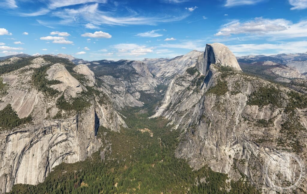
- Half Dome and the cables route: the most dramatic day hike in America — Half Dome (2,693 m; the most recognisable rock formation in the USA; the NW face (the 600-m sheer northwest face; the steepest large rock face in Yosemite; first climbed by Royal Robbins, Mike Sherrick, and Jerry Gallwas in 1957 — the most important technical first ascent in Yosemite before the El Capitan era); the cables route (the standard approach for non-climbers to the summit: the final 120 m (the “Subdome” approach and the cables): two steel cables fixed to the granite with wooden crossbars for footing; the most famous permitted day hike in the USA; a permit is required (the most sought-after NPS day-hiking permit in the USA: approximately 300 permits per day; typically sold out months in advance online; the most over-subscribed single-day hiking permit in American national park history)); the round-trip distance (the standard route from Happy Isles: 22–25 km; 1,463 m elevation gain; 10–12 hours; the hardest single-day permitted hike in the US national park system accessible without technical climbing equipment); the view from the summit (the most expansive granite panorama in the Sierra Nevada: the valley 1,474 m below; the Clark Range to the south-east; the Cathedral Range to the east; Half Dome’s flat summit (approximately 0.8 ha; the most disproportionately flat summit relative to its vertical approach of any mountain in North America))
- Heritage: UNESCO World Heritage Site, Yosemite National Park, inscribed 1984
- GPS: 37.7449° N, -119.5929° E
History
Indigenous history (the Ahwahneechee (the Southern Sierra Miwok people who lived in Yosemite Valley; they called the valley Ahwahnee (the Place of the Gaping Mouth); the most accurate topographical name in any Native American place-name in the Sierra Nevada; the Ahwahneechee (population approximately 100–500; the most isolated indigenous community in the central Sierra Nevada; they had lived in the valley for approximately 3,000 years)); the Mariposa Battalion (the first non-indigenous people to enter Yosemite Valley: the Mariposa Battalion, a California state militia pursuing the Ahwahneechee during the Mariposa Indian War (March 1851; the most militarily motivated first European entry into any major American national park; the name “Yosemite” (a version of the Ahwahneechee word for “they are killers” — the most accusatory place name in any national park; some sources interpret it as “those who kill” referring to the Ahwahneechee themselves as a warrior group)); the Yosemite Grant (1864; the most important piece of conservation legislation in American history before the national parks were created: President Abraham Lincoln signed the Yosemite Valley Grant Act on 30 June 1864, granting Yosemite Valley and the Mariposa Grove of sequoias to California for “public use, resort, and recreation” — the first time any government in the world had set aside land specifically for public enjoyment; the most consequential single presidential signature in the history of conservation); the national park (1890; the valley transferred back to federal control; the 3rd national park in the USA); UNESCO WHS 1984.
What you see
The Yosemite visit (the most important logistical challenge at Yosemite: the crowds; the valley floor (7.5 km² of the 3,081 km² park) receives approximately 90% of all visitors; all private vehicles must park at the day-use car parks or stay at a campground; the shuttle system (the free Valley Shuttle connects 21 stops around the valley loop; the most efficient way to travel within the valley; runs year-round)); the essential sights: Tunnel View (the first view of the valley from the east end of the Wawona Tunnel; the most photographed viewpoint in the USA; the view of El Capitan, Bridalveil Fall, and Half Dome simultaneously in one frame; best photographed in morning light); Yosemite Falls (739 m total drop in 3 sections; the highest waterfall in North America; fullest in April–May snowmelt; largely dry by August–September); the Mariposa Grove (the finest giant sequoia grove in Yosemite; the Grizzly Giant sequoia (approximately 2,700 years old — the oldest giant sequoia in Yosemite; 64 m tall; 9 m diameter; the most venerable single tree in the park)); Glacier Point (the viewpoint 975 m above the valley floor; the view of Half Dome from the same elevation as the summit — the most surprising single perspective change in any American national park: Half Dome appears low and accessible from Glacier Point, utterly unlike its vertical immensity when seen from the valley).
Practical information
- Getting there: Fresno Yosemite International Airport (FAT; 100 km south; the closest commercial airport; daily flights from Los Angeles (1h), San Francisco (1h 15min), Seattle (2h 30min), Las Vegas (1h)); Merced Regional Airport (MCE; 120 km south; YARTS buses to the valley (2h; the YARTS bus service from Merced train station — the most environmentally responsible approach to Yosemite; the Amtrak San Joaquin train from the Bay Area reaches Merced in 3h, connecting to YARTS for the 2h mountain ride into the valley — the most door-to-door public-transit friendly national park route in the USA)); by car from San Francisco (310 km; 3h 30min via CA-120 through the Big Oak Flat entrance (the Arch Rock entrance via CA-140 is the most scenic approach through the canyon of the Merced River); a reservation is required (the timed-entry permit (required for all vehicles entering the park in the summer high season (May–September); the most common entry mistake by first-time Yosemite visitors); book months in advance); by car from Los Angeles (520 km; 5h 30min via CA-99 and CA-41 through Mariposa))
- Sequoia and Kings Canyon National Parks: the largest trees in the world — Sequoia and Kings Canyon (100 km south of Yosemite (2h 30min drive); the finest giant sequoia forest in the world and the deepest canyon in the USA); the General Sherman Tree (the most important single tree in the world by volume: 84 m tall; 31 m circumference at the base; 1,385 m³ volume — the largest living organism by volume in the world; approximately 2,200 years old; the most visited tree in the USA); Kings Canyon (the deepest canyon in the USA: 2,400 m from the canyon walls to the Kings River (deeper than the Grand Canyon at this point — the most frequently disputed canyon depth claim in American geography; the Grand Canyon is deeper by total relief but Kings Canyon has a deeper single-point measurement)); the drive through Kings Canyon (the deepest scenic road in the USA: the road to Cedar Grove follows the canyon floor for 35 km at 1,370 m below the canyon rim — the most dramatic road descent in the California Sierra)
- Lake Tahoe and the Sierra Nevada: the finest mountain lake in North America — Lake Tahoe (90 km north of Yosemite (2h 30min drive); the most important alpine lake in the USA; 501 m deep (the 2nd deepest lake in the USA after Crater Lake; the deepest alpine lake in North America); the clarity (the most transparent large lake in the USA: Secchi disk visible at 21 m depth — the most precisely measured water clarity of any American lake; the clarity has declined from 33 m in 1967 (the most alarming single environmental data point in Tahoe’s recorded history) due to algae growth from nitrogen and phosphorus runoff; the most significant ongoing conservation problem in the Lake Tahoe basin); the skiing (the Palisades Tahoe (formerly Squaw Valley; the site of the 1960 Winter Olympics; the most historically significant ski resort in the USA; the mountain where the flame of the most politically complex Cold War Winter Olympics was lit (the 1960 Squaw Valley Olympics was the first televised Winter Olympics and the site of the first Olympic gold medal by an American in the biathlon))
Getting there
Fresno Airport (FAT) 100 km. YARTS bus from Merced (Amtrak) to valley 2h. Timed-entry vehicle permit required May–September (book months ahead). GPS: 37.7449, -119.5929.
Nearby
- Sequoia and Kings Canyon National Parks — 100 km south (2h 30min drive); the world’s largest trees and America’s deepest canyon — described in the Practical section; the essential Sierra Nevada combination: 2 days Yosemite (valley + Glacier Point + Mariposa Grove) + 1 day Kings Canyon (Cedar Grove; Roaring River Falls) + 1 day Sequoia (General Sherman Tree; Moro Rock — the finest 360° panorama in the Sierra Nevada accessible without a hike)
- Death Valley National Park — 290 km south-east of Yosemite (4h drive); the largest national park in the contiguous USA and the hottest, driest place in North America — Death Valley (the record temperatures: 56.7°C on 10 July 1913 at Furnace Creek — the highest reliably recorded air temperature on Earth; the elevation (Badwater Basin: -86 m; the lowest point in North America and the 2nd lowest on Earth after the Dead Sea)); Zabriskie Point (the most surreal landscape in the California desert: eroded badlands of mudstone in the Furnace Creek Formation (3 to 4 million years old); the same location as the 1970 Michelangelo Antonioni film; the most frequently associated landscape with Italian cinema in the American West)
- San Francisco — 310 km west (3h 30min drive); the most beautiful bay city in the USA and the gateway to Yosemite for most international visitors — San Francisco (the Golden Gate Bridge (1937; 2,737 m total length; 227 m tall towers; the most photographed bridge in the world; the most important steel suspension bridge of the 20th century; the Art Deco detailing — the finest decorative metalwork on any major bridge in North America)); Alcatraz (the most famous federal prison island in the world; the 1934–1963 penitentiary that held Al Capone, Robert Stroud the “Birdman,” and Machine Gun Kelly; the most visited single island in the San Francisco Bay; the ferry (30 min from Pier 33; the most important ferry journey in American heritage tourism)); the sourdough bread (the most distinctive local bread tradition in the USA: the San Francisco sourdough (the starter cultures in San Francisco contain a unique combination of yeasts and bacteria specific to the Bay Area microbiome (Lactobacillus sanfranciscensis — named after the city — the most place-specific single bacterium in artisanal bread production; the San Francisco starter culture has been maintained continuously by some bakeries for over 150 years))
Sources
- Wikipedia, Yosemite National Park; El Capitan; John Muir; Half Dome, accessed June 2026
- UNESCO, Yosemite National Park, WHS reference 308, inscribed 1984
- John Muir, The Yosemite, The Century Company, 1912
Find it on the map
See this place and what’s around it →📷 Diventa un fotografo di Cultural Heritage Online
Condividi le tue foto dei luoghi: restano pubblicate con la tua firma come autore. Più vengono viste, più ti fai conoscere — e presto un concorso premierà le foto più apprezzate.
Accedi o registrati gratis per aggiungere una foto