
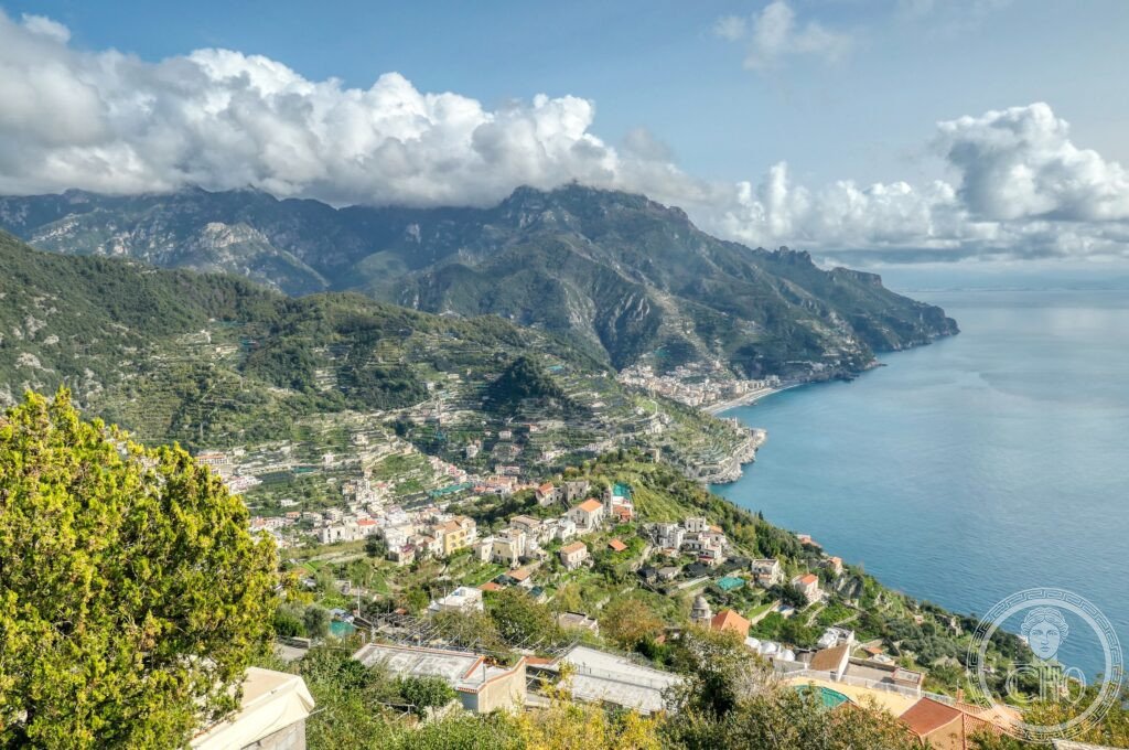
A forty-kilometre run of cliff and village between Vietri sul Mare and Positano, where lemon terraces, whitewashed towns and Baroque churches sit on ledges cut into the Lattari Mountains above the Tyrrhenian Sea. Inscribed by UNESCO in 1997, the coast is valued less for any single monument than for the whole landscape shaped by centuries of terracing, building and cultivation on near-vertical ground.
At a glance
The Amalfi Coast is a strip of Campania coastline where the Lattari Mountains fall almost straight into the sea, and where thirteen towns and villages, from Vietri sul Mare and Amalfi to Positano and the hill town of Ravello, have been built into the cliff over roughly two thousand years. UNESCO inscribed it in 1997 as a cultural landscape, recognising it as the product of continuous human modification of an extreme terrain rather than as an untouched natural setting.
The defining features are the fasce, narrow terraces held up by dry-stone walls and planted with lemon groves, olive trees and vines, and the architecture of the towns themselves, which shows Arab-Norman influence from the coast’s medieval trading links with North Africa. Majolica-tiled church domes in green and yellow, set against white walls and blue sea, are among the most recognisable images of the coast.
Key facts
- Status: UNESCO World Heritage Site, inscribed 1997, as a cultural landscape.
- Extent: roughly 40 kilometres of coast between Vietri sul Mare and Positano, served by the S.S. 163 road built between 1832 and 1853.
- Historic capital: Amalfi, seat of the medieval Republic of Amalfi, one of the four Italian maritime republics.
- Key monument: the Duomo di Sant’Andrea in Amalfi, with 9th-century foundations, a 13th-century facade remodelled in the 19th century, and the crypt said to hold the relics of St Andrew the Apostle.
- Produce: the Sfusato Amalfitano lemon, PGI-protected since 1994, grown on the terraced fasce and used in limoncello.
- Landscape features: the Emerald Grotto sea cave near Conca dei Marini and the Sentiero degli Dei footpath above the coast.
History
Amalfi was the capital of an independent maritime republic that traded across the Mediterranean, from Egypt to Byzantium, and is counted among the first of Italy’s four maritime republics, alongside Venice, Genoa and Pisa. Its rules for maritime conduct, the Tabula Amalfitana, were applied across the Mediterranean between the 11th and 16th centuries and are preserved in the town’s Museo Civico. Amalfitan tradition also credits a local sailor, Flavio Gioia, with inventing or perfecting the maritime compass, though the instrument is generally understood to have reached the Mediterranean via the Arab world from China, with Amalfitan sailors among its early users.
Long after the republic’s decline, the coast’s towns continued to shape the cliffside through terracing for lemon, olive and vine cultivation, work carried on by the same families over generations. The coastal road linking the villages was cut into the rock face in the first half of the 19th century, opening the area to wider travel and, later, to the tourism that made Positano and Ravello internationally known.
What you see
Amalfi itself centres on the Duomo di Sant’Andrea, reached by a steep flight of steps from the main piazza, with its striped Arab-Norman facade and mosaic decoration and a crypt holding the saint’s relics. The town also houses a Paper Museum recalling its historic role in papermaking. Positano, further along the coast, presents a near-vertical fall of white, pink and terracotta houses from the clifftop down to the pebble beach of the Spiaggia Grande, whose grey-black stones derive from volcanic sediment reworked by the sea.
Above the coast, Ravello sits on a spur of the Lattari Mountains and is known for the gardens of the Villa Rufolo, from whose cliff-edge terrace Richard Wagner drew inspiration for the second act of Parsifal after visiting in 1880, and the Villa Cimbrone, laid out in the early twentieth century with a long terrace of classical busts ending in an open view over the sea. The Ravello Festival brings classical music to the Villa Rufolo garden each summer. Elsewhere along the coast, the Emerald Grotto is a sea cave lit by an underwater green glow around its stalactites, and the Sentiero degli Dei is a footpath running above the villages with views down over the terraces and the sea.
Practical information
- Roads: the S.S. 163 links all the coastal towns but is narrow and heavily used in summer; local buses run the route, and driving requires caution on the hairpin bends.
- Sea travel: ferries connect Amalfi with Positano and other coastal towns and offer an alternative to the road.
- Visiting the Duomo and gardens: opening arrangements for the Duomo di Sant’Andrea, Villa Rufolo and Villa Cimbrone, and current festival dates, are best checked through their own official channels before travelling.
Getting there
The Amalfi Coast is reached along the S.S. 163 coastal road connecting Vietri sul Mare, Amalfi, Positano and the towns between them, or by ferry services linking the main harbours. Ravello lies above the coast on its own approach road from Amalfi.
Nearby
- Positano — along the coast road, the most vertical of the villages, its houses falling from the clifftop to the beach.
- Ravello — above Amalfi, home to the Villa Rufolo and Villa Cimbrone gardens and their sea views.
- Emerald Grotto — near Conca dei Marini, a sea cave with an illuminated underwater rock formation.
- Sentiero degli Dei — a path running above the coastal towns, used for walking with views over the terraces and sea.
Sources
- UNESCO
- Museo Civico, Amalfi
- Harper’s Bazaar
- Ravello Festival
Find it on the map
See this place and what’s around it →
📷 Become a Cultural Heritage Online photographer
Share your photos of places: they stay published under your name as the author. The more they're seen, the more you get noticed — and soon a contest will reward the most appreciated photos.
Log in or sign up free to add a photo