Grand Canyon National Park
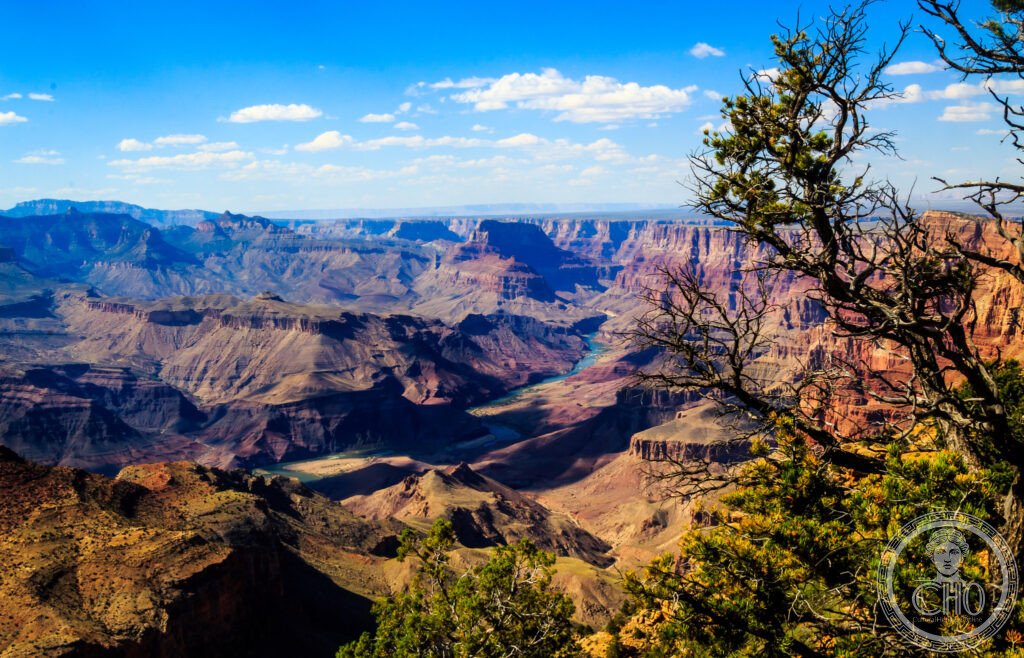
The most spectacular gorge on Earth and a 2-billion-year open book of geological history — the Grand Canyon of the Colorado River in Arizona is 446 km long, up to 29 km wide, and up to 1,857 metres deep; the horizontal rock layers in its walls record 2 billion years of Earth’s history in a single continuous section; approximately 6 million people visit each year, and most find that photographs and descriptions do not adequately prepare them for the first view.
At a glance
Grand Canyon National Park (493,077 hectares; established 1919; UNESCO WHS 1979) preserves the Grand Canyon, the deepest river canyon in the continental United States; the canyon was carved by the Colorado River over approximately 5–6 million years (some geological evidence suggests parts of the canyon are much older — up to 17 million years — though the question remains debated; the Canyon is certainly one of the most important geological sites in the world for the visibility and accessibility of deep geological time); the park is divided into the South Rim (open year-round; 2,134 m elevation; the historic Grand Canyon Village with the historic El Tovar Hotel, built 1905; 90% of visitors come here), the North Rim (open mid-May to mid-October only; 2,438 m elevation — 305 m higher than the South Rim, which creates a cooler microclimate; 10% of visitors; much quieter; accessible by road only from the north, adding 354 km to the trip from the South Rim despite being only 17 km across the canyon as the crow flies), the Inner Canyon (the canyon floor; the Bright Angel Trail and Kaibab Trail descend from the rims; the Colorado River at the bottom is 7–10°C year-round; Phantom Ranch, the only lodge at the bottom of the canyon, must be booked 1+ year in advance by lottery), and the remote West Rim (Skywalk; Hualapai tribal land; a separate fee).
Key facts
- The geology of the Grand Canyon: the most complete geological section visible anywhere on Earth — the rock layers visible in the Grand Canyon walls record approximately 2 billion years of geological history (approximately 40–45% of the total age of the Earth) in a nearly undisturbed horizontal sequence; the lowest (oldest) formation, the Vishnu Basement Rocks (1.84 billion years old; exposed on the canyon floor; dark schist and pink granite formed deep in the Earth’s crust during an ancient mountain-building episode) is separated from the next formation above by a gap of approximately 1.25 billion years (the Great Unconformity — the most dramatic known gap in the geological record; the missing rock represents 25% of Earth’s entire history; the exact cause of this gap is disputed); the overlying formations record shallow tropical seas (Cambrian Period, 540–490 million years ago), coastal deserts (Permian Period, 250 million years ago), and ancient floodplains (Triassic Period, 230 million years ago); the youngest exposed formation (Kaibab Limestone; 270 million years old) forms the present canyon rim; the Colorado River that carved the canyon flows through rock 1.84 billion years old — standing at the river’s edge, you are surrounded by stone that was formed when only single-celled organisms existed on Earth
- The Colorado River and the white-water rapids: one of the great wilderness river experiences on Earth — the Colorado River flows 330 km through the Grand Canyon (the section within the park boundaries; from Lees Ferry, Arizona to Diamond Creek, Arizona; the standard commercial and private rafting section); the canyon has 160+ named rapids (the most dramatic include Crystal Rapids, Hermit Rapids, and Lava Falls — the most powerful commercially run rapid in North America; a wall of white water at the bottom of a basalt lava flow that dammed the canyon 1,000 years ago); commercial rafting trips through the full length of the canyon take 10–18 days (motorized raft: 7 days; oar-powered raft: 12–14 days; private trip: 14–21 days); places on commercial trips are taken months to years in advance; the private river permit system is a lottery (approximately 16,000 applicants for approximately 400 launch dates per year); all camping in the canyon requires a permit (backcountry permit; quota system; extremely competitive in spring and autumn)
- The Canyon’s ecosystems: the elevation difference between canyon floor and rim creates 5 distinct life zones in a single vertical mile — the Canyon contains: the Lower Sonoran zone (the canyon floor and inner gorge; desert habitat; temperatures above 40°C in July; the Ringtail (Bassariscus astutus) and the Western Diamondback rattlesnake); the Upper Sonoran zone (the canyon walls from 600–2,100 m; pinyon-juniper woodland; the California Condor — with a 2.8 m wingspan, the largest flying bird in North America; reintroduced to the Grand Canyon in 1996 after being reduced to 22 individuals worldwide; approximately 80–100 condors now range over the canyon and can often be seen soaring on thermals above the South Rim); the Transition zone (the South Rim; ponderosa pine forest; mule deer); the Canadian zone (the North Rim; mixed conifer forest); the Hudsonian zone (the highest North Rim areas; spruce-fir forest); the Colorado River corridor is also a critical flyway for migratory birds
- Heritage: UNESCO World Heritage Site, Grand Canyon National Park, inscribed 1979
- GPS: 36.1069° N, -112.1129° W
History
The Grand Canyon has been inhabited by various Native American peoples for approximately 4,000 years (the Hualapai, Havasupai, Navajo, Hopi, and others have significant connections to the canyon; the canyon is a sacred site for many tribes); the first European to see the canyon was the Spanish explorer García López de Cárdenas in 1540; John Wesley Powell led the first recorded river trip through the full length of the canyon in 1869 (a wooden boat expedition that nearly ended in disaster multiple times; Powell’s journals of the trip are among the great accounts of American exploration); Theodore Roosevelt visited in 1903 and declared: “Leave it as it is. You cannot improve on it. The ages have been at work on it, and man can only mar it”; National Monument 1908; National Park 1919; UNESCO WHS 1979.
What you see
The South Rim: Mather Point (the first view for most visitors; the shuttle bus stop closest to the main visitor centre; the canyon panorama from the paved viewpoint overlooks the Bright Angel Canyon and the Tonto Platform; the Phantom Ranch buildings are visible 1,400 m below with binoculars), Bright Angel Trail (the most popular inner-canyon trail; begins at the South Rim at 2,134 m; 19.3 km to the Colorado River; day hikers should turn back by 10am in summer — the descent is deceivingly easy; the climb back in afternoon heat is dangerous; the Park Service has 12+ rescues per day in summer from unprepared day hikers; Indian Garden (now Havasupai Gardens) at 4.8 km and 1.5 km down is a comfortable turnaround for fit day-hikers), the historic El Tovar Hotel (built 1905; on the canyon rim; the historic arts-and-crafts stone-and-wood building is the finest lodging in the park; views from the porch directly into the canyon; book 6–12 months in advance), and Desert View (45 km east of Grand Canyon Village; the east entrance; the historic Desert View Watchtower by architect Mary Jane Colter, 1932; the best 360° view of the canyon).
Practical information
- Admission: USD $35 per vehicle per 7 days; the America the Beautiful Annual Pass (USD $80) is the best value for multiple parks; the South Rim is open year-round; shuttle buses within the park are free and reduce traffic congestion; the historic Village shuttle route runs every 10 min in summer; Grand Canyon Railway (historic steam train from Williams, Arizona to the South Rim; 2h 15 min each way; the most atmospheric way to arrive without a car; book online at thetrain.com)
- Getting there: the nearest airports are Flagstaff Pulliam Airport (FLG; Flagstaff, Arizona; 1h 30 min from the South Rim; small commuter airport with limited flights); Phoenix Sky Harbor (PHX; 4h drive from the South Rim; the most practical option for international visitors; 3.5h drive on I-17 and US-180); the Grand Canyon Airport (GCN; on the South Rim; served by Grand Canyon Airlines from Las Vegas; helicopter tours depart from here); from Las Vegas: 4h 30 min by car (430 km; the most common origin for visitors combining Las Vegas and the Grand Canyon); Greyhound and tour buses from Las Vegas, Phoenix, and Flagstaff
- Practical warnings: dehydration and heat exhaustion are the leading causes of medical emergencies in the park (3 million + visitors + 40°C summer temperatures + steep descents that tempt visitors into the canyon during the hottest hours = dangerous combination; carry 1 litre of water per hour of hiking in summer; start all hikes before 7am in July–August; if you feel dizzy or stop sweating in the heat, you may be in serious danger); the condors (visible from the South Rim year-round; often perched on the canyon rim near viewpoints; wing tags identify individual birds in the recovery programme); lodging inside the park (the El Tovar, Bright Angel Lodge, and Phantom Ranch) books out 6–13 months in advance; nearby Williams, Arizona (90 km south) has abundant affordable lodging as a base
Getting there
4h 30 min from Las Vegas by car, 4h from Phoenix. Grand Canyon Railway from Williams (2h 15 min). GPS: 36.1069, -112.1129.
Nearby
- Zion National Park (Utah) — 160 km north of the Grand Canyon North Rim (2h 30 min by car; 260 km from the South Rim, 3h); one of the most beautiful slot canyon landscapes in the American Southwest — Zion National Park (148,733 hectares; established 1919) is centred on Zion Canyon (the “Heavenly City of God” to the Mormon settlers who named it; a 24-km canyon cut by the North Fork of the Virgin River through Navajo Sandstone; the canyon walls rise 600–800 metres from the canyon floor); the park is famous for the Narrows (the upper Virgin River gorge; the canyon walls are 20 metres apart at points; visitors walk in the river itself; one of the great slot canyon hikes in the world), Angel’s Landing (a 1,448 m summit with a 600 m sheer drop on each side; the final 400 m ascent on chains and smooth rock is one of the most thrilling day hikes in the USA; a permit is required as of 2022), and the Emerald Pools (hanging gardens of maidenhair fern fed by desert spring seeps)
- Bryce Canyon National Park (Utah) — 230 km north of the Grand Canyon North Rim (3h); the largest and most bizarre concentration of hoodoos (erosion pinnacles) on Earth — Bryce Canyon (14,502 hectares; established 1928; not technically a canyon — it is the eroded eastern edge of the Paunsaugunt Plateau, 2,700 m above sea level) contains the Bryce Amphitheatre, a natural bowl approximately 3 km wide and 300 m deep filled with thousands of hoodoos (tall slender spires of sedimentary rock in pink, white, orange, and red; the word “hoodoo” may derive from Voodoo or from a Paiute term meaning “legend people”; the erosion process that creates them is still active — the rim retreats approximately 30 cm per year; the hoodoos that exist today will be gone in perhaps 3 million years); the park has exceptional dark skies and is one of the best stargazing destinations in the National Park system
- Monument Valley Navajo Tribal Park — 200 km east of the Grand Canyon South Rim (2h 30 min); the most photographed landscape in the American West and one of the most recognisable landscapes on Earth — Monument Valley (the Navajo name is Tsé Biiʼ Ndzisgaii, “the place where the rocks are tall”; a section of the Colorado Plateau straddling the Arizona–Utah border; administered by the Navajo Nation, not the US National Park Service — admission fees go directly to the tribe) is the cluster of red sandstone mesas and buttes (the Mittens, Merrick Butte, Elephant Butte, the Totem Pole) that have formed the backdrop of a hundred Hollywood westerns (John Ford shot eight films here with John Wayne; the “John Ford Point” overlook is the most photographed single viewpoint in Monument Valley); the only way to enter the valley itself (beyond the road to the visitor centre and Viewpoint) is on a guided Navajo tour
Sources
- Wikipedia, Grand Canyon; Grand Canyon National Park; Colorado River, accessed June 2026
- UNESCO, Grand Canyon National Park, WHS reference 75, inscribed 1979
- John Wesley Powell, The Exploration of the Colorado River and Its Canyons, Flood and Vincent, 1895 (public domain)
Find it on the map
See this place and what’s around it →📷 Diventa un fotografo di Cultural Heritage Online
Condividi le tue foto dei luoghi: restano pubblicate con la tua firma come autore. Più vengono viste, più ti fai conoscere — e presto un concorso premierà le foto più apprezzate.
Accedi o registrati gratis per aggiungere una foto