Cultural Landscape of Bali — Subak Irrigation System
A thousand-year-old irrigation management system governed by water temples and shaped by Balinese cosmology — the Subak system of Bali manages water distribution to the island’s interlocking rice terraces through a network of cooperative farmer groups organized around water temples, from the supreme Pura Ulun Danu Batur at the volcanic caldera rim down to individual field temples, a system that has sustained continuous rice cultivation since approximately the 9th century AD.
At a glance
The UNESCO Cultural Landscape of Bali (WHS reference 1194; inscribed 2012) encompasses five component areas: the Pura Ulun Danu Batur water temple on the rim of the Batur volcano caldera (the supreme water temple of Bali; the goddess Dewi Danu is worshipped here as the source of all waters in Bali; the head priest of the temple coordinates water allocation across the island); the Batur caldera and lake (the source of the underground water that feeds the Balinese rice terraces through volcanic aquifers; the water flows from the caldera lake through the porous volcanic rock of Bali and emerges as springs lower down the mountain); the rice terraces of Jatiluwih in Tabanan Regency (approximately 700 hectares of the most intact and spectacular terraced rice fields in Bali; the most visited of the five components); the Pura Taman Ayun (the state temple of the former Mengwi Kingdom; 17th century; one of the finest traditional Balinese royal temples); and the Pura Ulun Danu Bratan (a water temple on Lake Bratan in the Bedugul Highland; one of the most photographed temples in Bali, built partially on a small island in the lake and partially on the lakeside).
Key facts
- The Subak system — cooperative irrigation governed by temples: one of the world’s oldest surviving examples of ecologically rational agriculture — the Subak (an Old Balinese word for a cooperative rice irrigation group) is both a social organization (each subak is an autonomous group of rice farmers who share a common water source; there are approximately 1,300 individual subaks in Bali, each with between 50 and 400 member families) and a physical irrigation network (a system of channels, weirs, and tunnels that distributes water from the volcanic mountain springs to the terraced rice fields); the key innovation of the Subak that sets it apart from other traditional irrigation systems is its governance by a hierarchy of water temples: each subak has its own temple (Pura Subak), but the temples are connected in a hierarchical network managed by the regional temple (which coordinates upstream-downstream water sharing between different subaks) up to the supreme temple at the Batur volcanic caldera (the ultimate authority on water allocation for the whole island); the decisions about irrigation timing and crop rotation are made at temple ceremonies, where the rice farmers coordinate their planting schedule to manage the Balinese rice brown planthopper pest (a rice pest that collapses when all farmers synchronize fallow periods, depriving the pest population of continuous food); the research of agricultural ecologist J. Stephen Lansing (who discovered the ecological rationale for the water temple system in the 1980s) showed that the temple-coordinated planting calendar outperforms both the traditional calendar and the Green Revolution top-down planning approach in terms of yield stability and pest management
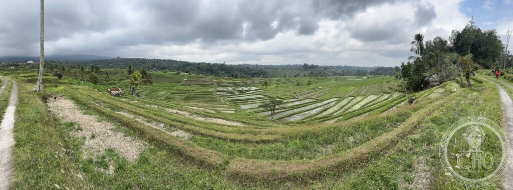
- Jatiluwih rice terraces (Tabanan Regency): the most extensive intact traditional rice terrace landscape in Bali — the Jatiluwih terraces (approximately 700 hectares; altitude 400–800 metres above sea level; in the highlands of Tabanan Regency, 45 km north-west of Denpasar; 37 km from Ubud) represent the most intact surviving example of the traditional Balinese irrigation landscape; the terraces here are cultivated with traditional Balinese rice varieties (padi bali; a long-stalked tall-growing variety that takes approximately 6 months to mature; distinctly different from the high-yield short-stalked Green Revolution varieties introduced across Asia in the 1970s; the padi bali has lower yield but superior flavour and cultural significance); the terraces were threatened in the 1970s–1980s when the Indonesian government’s Green Revolution programme required farmers to adopt high-yield rice varieties and synthetic pesticides, which disrupted the water temple calendar and caused pest outbreaks (the aphid population exploded when synchronised fallow periods were abandoned); the programme was reversed in the 1990s and the Subak system was restored; the current landscape is approximately as it appeared 200 years ago
- The philosophy of tri hita karana: the Balinese cultural framework underlying the Subak — the tri hita karana (“three causes of prosperity” in Balinese Sanskrit; the three relationships that must be kept in harmony for human wellbeing: the relationship between humans and the divine, the relationship between humans and nature, and the relationship between humans and other humans) is the overarching philosophical framework of Balinese Hindu-Buddhist culture; the Subak system is considered an expression of tri hita karana: the water temples maintain the relationship between farmers and the divine (through ceremony and offering); the cooperative irrigation system maintains the relationship between humans and nature (ensuring the rice terraces function as an ecosystem, not just a production system); and the cooperative farmer groups maintain social harmony between farmers; the UNESCO inscription specifically recognised the tri hita karana as a cultural concept of Outstanding Universal Value
- Heritage: UNESCO World Heritage Site, Cultural Landscape of Bali: the Subak System as a Manifestation of the Tri Hita Karana Philosophy, inscribed 2012
- GPS: -8.3640° S, 115.1460° E
History
The earliest Balinese water temples may date from the 9th century AD (the Subak system is mentioned in a Balinese inscription from 882 AD); the Mengwi Kingdom (17th century) built the Pura Taman Ayun as its state temple and coordinated the Subak system across the western Bali region; the Dutch colonial period (early 20th century) left the Subak system largely intact; the post-independence Indonesian government introduced the Green Revolution (1970s; high-yield varieties and synthetic fertilisers; the programme disrupted the water temple calendar with catastrophic pest outbreaks); the failure of the Green Revolution approach was documented by J. Stephen Lansing in 1991 and the traditional system was largely restored by the mid-1990s; UNESCO WHS inscription 2012.
What you see
The Jatiluwih terraces (the most scenic and most accessible component; a 3–4 km walking trail through the terraces; the path runs along the bunds dividing the irrigated paddies; in the growing season the terraces are a deep green; at harvest time they turn gold; the views across the valley to the terraced hillside give the full sense of the landscape); the Pura Taman Ayun (the most complete and best-maintained traditional Balinese royal temple; moated on three sides; the inner courtyard with its tiered meru (multi-roofed towers) and split gate is the definitive image of Balinese temple architecture; a short detour from the Denpasar–Jatiluwih road); and the Pura Ulun Danu Bratan (the most photographed temple in Bali, on the shore of Lake Bratan in the Bedugul Highlands; at dawn the temple appears to float on the water; at midday the surrounding gardens and the lake are equally photogenic).
Practical information
- Admission: Jatiluwih rice terrace trail: approximately IDR 40,000 (approximately USD $2.50; 2026 rates); parking IDR 5,000; the trail is well-maintained with English signage; refreshment warung (basic restaurants) at the car park; guided walks available at the entrance; Pura Taman Ayun: approximately IDR 20,000; traditional sarong required (available for loan at the entrance); Pura Ulun Danu Bratan: approximately IDR 30,000; one of the most crowded tourist sites in Bali, especially at dawn
- Getting there: from Ubud (37 km north-west; approximately 1h 30 min by car or motorbike via the Pura Taman Ayun road; most easily visited as a day trip from Ubud or Seminyak); from Denpasar (55 km north; 1h 30 min); no reliable public transport for Jatiluwih; hire a driver for the day from Ubud or Seminyak (approximately USD $40–60 for a full-day driver with Jatiluwih + Bedugul + Tanah Lot circuit); the circuit Jatiluwih → Bedugul (Pura Ulun Danu Bratan + botanical gardens) → Tanah Lot sunset temple is the most popular day trip in Bali
- Ubud and Balinese arts: the base for visiting Jatiluwih is typically Ubud (approximately 37 km south-east); Ubud is the cultural centre of Bali (traditional Balinese painting, carving, dance, and music are all centred here; the Ubud royal palace — Puri Saren Agung — hosts Kecak and Legong dance performances nightly; the Blanco Renaissance Museum; the Neka Art Museum; and the Sacred Monkey Forest Sanctuary are the primary Ubud attractions; the rice terraces of Campuhan Ridge and Tegallalang near Ubud are the most accessible and most photographed terraces in Bali, though much smaller than Jatiluwih)
Getting there
From Ubud: 37 km north-west (1h 30 min by car). From Denpasar: 55 km north (1h 30 min). Private driver recommended. GPS: -8.3640, 115.1460.
Nearby
- Tanah Lot Sea Temple — 35 km south-west of Jatiluwih (45 min by car); the most visited sunset temple in Bali — the Pura Tanah Lot (Balinese: “Temple on a Sea Rock”) is a Hindu sea temple built on a small rocky outcrop approximately 50 metres offshore in the Indian Ocean, accessible on foot at low tide; the temple is dedicated to the sea guardian deity and is one of the seven sea temples of Bali (the temples are placed to be within sight of each other, forming a protective chain around the island); the sunset view of the temple silhouetted against the orange sky is the most iconic image of Bali; the surrounding cliff and beach area has been heavily developed for tourism (large car parks, commercial stalls, a luxury hotel) but the temple itself retains its sacred status and active ceremony calendar
- Tegallalang Rice Terraces and Ubud — 37 km south-east of Jatiluwih (45 min by car); the most accessible rice terrace landscape near Ubud — the Tegallalang rice terraces (approximately 7 km north of Ubud town centre on the main Ubud–Kintamani road) are the most visited rice terraces in Bali and the standard introduction to the Subak system for visitors based in Ubud; the terraces are smaller and more crowded than Jatiluwih but offer excellent access and walking, cafes with terrace views, and a collection of small artisan studios selling wood carvings and silver jewellery along the terrace path; Ubud itself (the cultural capital of Bali; population approximately 80,000; 25 km north of Denpasar; altitude approximately 200 metres) is the standard base for exploring the interior of Bali
- Mount Batur caldera and Pura Ulun Danu Batur — 40 km north-east of Jatiluwih (1h 30 min by car via Kintamani); the volcanic source of Bali’s water and the supreme water temple — Mount Batur (1,717 m; an active stratovolcano; last eruption 2000) sits inside the much larger Batur caldera (10 km × 13.8 km; one of the largest calderas in Indonesia); the caldera contains Lake Batur (the largest lake in Bali and the primary source of the underground water that feeds the Balinese rice fields through volcanic aquifers); the Pura Ulun Danu Batur (the supreme water temple; on the outer caldera rim at Kintamani; the setting overlooking the caldera, the black lava flows of the 1917 and 1926 eruptions, and the lake far below is one of the most dramatic in Bali) coordinates water allocation across the entire island; the Mount Batur sunrise trek (3–4 hours return from the caldera floor; steep volcanic ash path; a licensed guide required; the crater still emits steam and the views at dawn over the caldera are extraordinary) is one of the most popular active volcano experiences in Indonesia
Sources
- Wikipedia, Subak (irrigation); Jatiluwih rice terraces; Tri Hita Karana, accessed June 2026
- UNESCO, Cultural Landscape of Bali, WHS reference 1194, inscribed 2012
- J. Stephen Lansing, Priests and Programmers: Technologies of Power in the Engineered Landscape of Bali, Princeton University Press, 1991
Find it on the map
See this place and what’s around it →📷 Diventa un fotografo di Cultural Heritage Online
Condividi le tue foto dei luoghi: restano pubblicate con la tua firma come autore. Più vengono viste, più ti fai conoscere — e presto un concorso premierà le foto più apprezzate.
Accedi o registrati gratis per aggiungere una foto