Iguazu National Parks
The widest waterfall system in the world and one of the most powerful natural spectacles on Earth — the Iguazu Falls, shared between Argentina and Brazil on the Iguazu River, consist of approximately 275 individual waterfalls spread across 2.7 km of the river frontage; Eleanor Roosevelt, on seeing the falls for the first time in 1944, reportedly said “Poor Niagara”; the Garganta del Diablo (Devil’s Throat) falls alone discharges more water in a second than Niagara Falls discharges in a minute during peak flow.
At a glance
The Iguazu Falls straddle the border between the Misiones Province of Argentina and the Paraná State of Brazil, on the Iguazu River approximately 20 km upstream of its confluence with the Paraná River; the Argentine side (Parque Nacional Iguazú; 67,600 hectares of subtropical Atlantic Forest surrounding the falls; the town of Puerto Iguazú 18 km west is the main Argentine base) gives the most direct and immersive experience of the falls (the Argentine side has more trails, closer views, and the famous walkway above the Garganta del Diablo); the Brazilian side (Parque Nacional do Iguaçu; 185,000 hectares of protected forest on the Brazilian side; the town of Foz do Iguaçu across the Paraná River from Puerto Iguazú is the main Brazilian base) gives the panoramic overview of the full 2.7 km of falls frontage from a cliff-top path; both sides are usually visited in a single trip; the Brazilian side can be done in a half-day; the Argentine side requires a full day (or 2 days to see everything); crossing the border requires only a passport or national ID card (for most nationalities); the Foz do Iguaçu/Puerto Iguazú airport (FOZ; also called Cataratas International Airport) serves direct flights from Buenos Aires, São Paulo, and Rio de Janeiro.
Key facts
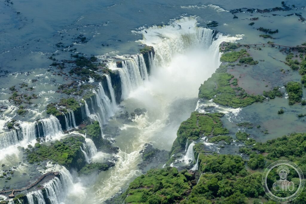
- The scale of the Iguazu Falls: the widest waterfall system in the world — the Iguazu Falls consist of approximately 275 individual falls (the number varies with water level; in very high water some of the smaller falls merge) arranged in a roughly horseshoe shape over a frontage of approximately 2.7 km (for comparison: Victoria Falls, on the Zambia–Zimbabwe border, has a frontage of 1.7 km; Niagara Falls, on the Canada–USA border, has a frontage of 0.9 km); the total average flow of the Iguazu River at the falls is approximately 1,756 m³/s (1,756 tonnes of water per second; this is approximately 12 times the average flow of Niagara Falls); in flood conditions (typically during the Southern Hemisphere autumn, March–May), the flow can exceed 10,000 m³/s and the entire river becomes a single continuous cataract; in extreme drought the falls are reduced to a small fraction of normal volume and individual boulders in the riverbed appear above the waterline; the falls drop between 60 and 82 metres; the Garganta del Diablo is the deepest and most powerful fall at 82 metres
- The Garganta del Diablo (Devil’s Throat): the centrepiece of the falls and the most dramatic natural phenomenon in the Americas — the Garganta del Diablo (Spanish: “Devil’s Throat”; Guaraní: “Great Water”) is a U-shaped canyon approximately 150 metres wide and 700 metres long at the point where the Iguazu River divides into two channels and the entire flow of the upper river falls 82 metres into the lower gorge; the volume of water plunging into the canyon creates a permanent column of spray (visible from 25 km in clear conditions) and a roar audible from several kilometres; the walkway over the Garganta del Diablo (on the Argentine side; a 1 km boardwalk over the river approaches the canyon edge; the last 50 metres are directly above the falls) is one of the most vertiginous and overwhelming natural spectacle viewpoints on Earth; visitors on the walkway are drenched by spray from the falls below; the viewing platform at the canyon edge gives a direct view down into the white water cauldron; the Brazilian side has a panoramic view of the Garganta del Diablo from across the canyon (the far wall of the canyon, 700 metres away, from which the white column of spray rises against the surrounding green forest)
- The subtropical Atlantic Forest and wildlife: one of the most biodiverse regions in South America — the subtropical Atlantic Forest (Mata Atlântica; the original forest that covered the Atlantic coast of Brazil and inland areas; now reduced to approximately 11% of its original extent due to deforestation for agriculture — one of the most threatened biomes on Earth) is preserved in the Iguazu National Parks; the forest at Iguazu supports: the jaguar (Panthera onca; the largest cat in the Americas; the parks contain one of the most important jaguar corridors in South America; camera traps have recorded multiple individual jaguars in the Argentine park; sightings by visitors are extremely rare), the giant anteater (Myrmecophaga tridactyla; seen on the forest trails on both sides), the giant otter (Pteronura brasiliensis), coati (a small raccoon-relative; extremely habituated to humans; present on all the trail systems; an entertainment and occasional nuisance at picnic areas), the toco toucan (Ramphastos toco; ubiquitous; the orange-billed toucan commonly seen in the trees above the falls walkways), and approximately 448 bird species including the Great Dusky Swift (Cypseloides senex; swarms of thousands of these swifts fly into the spray of the Garganta del Diablo and roost on the cliffs behind the falling water)
- Heritage: UNESCO World Heritage Site, Argentine side (Iguazu National Park) inscribed 1984; Brazilian side (Iguaçu National Park) inscribed 1986
- GPS: -25.6953° S, -54.4367° W
History
The falls were known to the Guaraní people for millennia (the Guaraní name is “Y Guazú”, “Big Water”); the first European to see the falls was the Spanish explorer Álvar Núñez Cabeza de Vaca in 1541; the area was a Jesuit mission territory in the 17th–18th centuries; Argentine ownership of the falls area was contested with Brazil until the arbitration award of 1895 (the US President Grover Cleveland was the arbitrator; he awarded the disputed territory to Argentina); the Argentine National Park was created in 1934 (the first national park in Misiones Province); UNESCO WHS inscription 1984 (Argentina) and 1986 (Brazil); both parks were placed on the World Heritage in Danger list in 1999 (Argentine side) and 2001 (Brazilian side) due to illegal hunting and forest encroachment; removed from the Danger list in 2001 and 2003 respectively after management improvements.
What you see
Argentine side (full day; enter from Puerto Iguazú): the Circuito Superior (upper circuit trail along the top of the falls; 1.6 km; multiple viewpoints including the top of the Garganta del Diablo walkway); the Circuito Inferior (lower circuit trail along the base of the falls; 1.7 km; the best for views upward from below the falls, including the directly frontal view of the Salto Bossetti); the Garganta del Diablo walkway (1 km boardwalk; arrives at the canyon edge above the Devil’s Throat; the most dramatic viewpoint; closes immediately if water levels are too high); Brazilian side (half day; best for the panoramic frontage view): a single 1.5 km clifftop walk facing the Argentine side with continuous view of the full falls width; the boat ride below the falls (offered on both sides; on the Brazilian side, the boats pass directly through the edge of a major falls; the experience is a complete drenching).
Practical information
- Admission: Argentine side: approximately ARS 6,000 (approximately USD $15 at 2026 exchange rates; Argentine peso is volatile; verify locally); Brazilian side: approximately BRL 100 (approximately USD $20); open daily 8am–6pm (Argentine side); 9am–5pm (Brazilian side); the Garganta del Diablo walkway requires an additional train ride (included in the entrance fee); boat excursions (crossing the national park fee) approximately USD $45–65 per person additional
- Getting there: the nearest airport is Foz do Iguaçu/Cataratas International Airport (FOZ; in Brazil, 15 km from the Argentine park entrance and 25 km from the Brazilian park entrance; direct flights from Buenos Aires EZE (1h 45 min) and GRU São Paulo (1h 30 min) and Congonhas São Paulo (1h 45 min); connections via Buenos Aires from all international gateways; taxis from the airport to Puerto Iguazú (Argentina) approximately USD $25; free shuttle buses from both town centres to the park entrances run frequently; the border crossing between Argentina and Brazil at the Tancredo Neves International Bridge does not require stopping for most nationalities (passport is stamped on each side)
- When to go: the falls can be visited year-round; the highest water levels (most spectacular volume; the entire falls front becomes a wall of white water; the Garganta del Diablo closes when water is too high to approach) are March–May (end of the Brazilian summer rainy season); the driest conditions (lowest water; the falls are still impressive but individual boulders appear in the riverbed) are August–October; temperatures are warm year-round (25–35°C in summer; 15–25°C in winter); humidity is always high near the falls; wildlife is easiest to see in the early morning (coatis, toucans, giant anteaters) and at dawn/dusk (jaguars very rarely)
Getting there
Foz do Iguaçu Airport (FOZ) — 1h 45 min from Buenos Aires, 1h 30 min from São Paulo. Free shuttles to both park entrances. GPS: -25.6953, -54.4367.
Nearby
- Jesuit Missions of the Guaraní (San Ignacio Miní) — 230 km south of Puerto Iguazú (3h by road through Misiones Province); the finest ruins of the Jesuit reductions in Argentina — the Jesuit reductions (reduciones jesuíticas; the missions established by the Society of Jesus among the Guaraní people of the upper Paraná basin from 1609 to 1767) are one of the most extraordinary social experiments in colonial history: communities of 2,000–8,000 Guaraní people governed by Jesuit priests according to communal principles, with workshops producing musical instruments, astronomical equipment, and books; the ruins of San Ignacio Miní (a reduction built in 1632; UNESCO WHS 1983 along with the ruins in Brazil and Paraguay; the church ruins of reddish Paraná sandstone, with carved baroque decorative elements in Guaraní style, stand to a height of several metres in a jungle clearing) are the most accessible and best-preserved in Argentina; see also the Jesuit Missions of the Chiquitos (separate CHO place card) in Bolivia
- Itaipu Dam and hydroelectric complex — 20 km north of Foz do Iguaçu (20 min by road; on the Brazilian–Paraguayan border on the Paraná River); the most powerful hydroelectric dam in the world by annual energy production — the Itaipu Dam (built 1975–1984; 196 metres high; the reservoir extends 170 km upstream; the powerhouse has 20 turbines; annual energy production 103.1 TWh in 2016, a world record; supplies approximately 17% of Brazil’s electricity and 76% of Paraguay’s electricity; the construction required the relocation of approximately 10,000 families); guided tours of the dam (daily from both the Brazilian and Paraguayan sides; the Brazilian side visitor centre is the most comprehensive; the “Itaipu Panoramic” tour includes the dam crest walk and the turbine hall visit; the night illumination tour on the Brazilian side is spectacular)
- Wanda Mines and Tierra Colorada — 80 km south-east of Puerto Iguazú (1h by road; Misiones Province); the only amethyst and topaz gem mines open to visitors in Argentina — the Wanda area of northern Misiones Province sits on a basalt formation studded with amethyst geodes and topaz crystals; the gem mines (privately operated; open for guided tours; the guides break open fresh geodes with hammers to show the crystal structure inside; visitors can purchase raw amethyst, topaz, and other semi-precious stones directly from the miners at wholesale prices) are a popular and accessible complement to the Iguazu National Park visit; the characteristic red earth of Misiones Province (terra roxa; a distinctive red tropical clay weathered from basalt that stains roads, buildings, and vegetation) is most vividly apparent in this area
Sources
- Wikipedia, Iguazu Falls; Iguazu National Park; Iguaçu National Park, accessed June 2026
- UNESCO, Iguazu National Park (Argentina), WHS reference 303, inscribed 1984; Iguaçu National Park (Brazil), WHS reference 355, inscribed 1986
- Administración de Parques Nacionales de Argentina, Parque Nacional Iguazú, official management plan
Find it on the map
See this place and what’s around it →📷 Diventa un fotografo di Cultural Heritage Online
Condividi le tue foto dei luoghi: restano pubblicate con la tua firma come autore. Più vengono viste, più ti fai conoscere — e presto un concorso premierà le foto più apprezzate.
Accedi o registrati gratis per aggiungere una foto