Ha Long Bay
One of the world’s most extraordinary seascapes — approximately 1,969 limestone islands and islets rising vertically from the Gulf of Tonkin in north-east Vietnam, sculpted by 500 million years of geological processes into towers, arches, grottoes, and floating villages that have anchored Vietnamese cultural identity since the earliest written records; UNESCO World Heritage for outstanding natural beauty and extraordinary geological value.
At a glance
Ha Long Bay (Vịnh Hạ Long, “Bay of the Descending Dragon”) is a marine bay in Quảng Ninh Province, north-eastern Vietnam, approximately 165 km east of Hanoi. The bay covers 1,553 km² of water, of which the UNESCO World Heritage core zone encompasses 434 km²; the bay contains approximately 1,969 islands (classified geological estimate) and islets of Carboniferous–Permian limestone, most uninhabited, ranging from low-lying reefs to spectacular vertical towers 200 metres tall. The bay opens to the Gulf of Tonkin and is part of the larger Bái Tử Long Bay complex to the north-east (less visited but geologically continuous). UNESCO first inscribed Ha Long Bay for natural beauty in 1994 and extended the inscription to include geological value in 2000.
Key facts
- The geology: the limestone of Ha Long Bay was deposited as marine sediment in shallow tropical seas approximately 500 million years ago (Ordovician to Carboniferous), then uplifted by tectonic forces 340 million years ago and exposed to approximately 340 million years of weathering; the distinctive tower-karst and fenglin (isolated-tower) formations were produced during the Cenozoic by a combination of chemical dissolution (karstification), fluvial erosion during lower sea-level periods, and the gradual rise of sea level after the last glacial maximum (approximately 10,000–18,000 years ago), which flooded the former valleys and left the limestone towers as islands; the result is a marine karst landscape at a stage of erosion that does not occur anywhere else at this scale
- The name — Dragon mythology: Vietnamese legend attributes the creation of Ha Long Bay to a family of dragons sent by the Jade Emperor to defend Vietnam against invasion: the dragons descended from heaven (hạ long = “descending dragon”) and spat out jewels and jade that became the limestone islands, which blocked the enemy fleet; the dragons then remained in the bay as its protectors; the mythological associations of the bay with dragons are deep in Vietnamese culture and explain the naming pattern of many islands (Dragon Island, Dragon’s Head Island, Sleeping Dragon Island)
- The Thien Cung (Heavenly Palace) Grotto: the most elaborate cave in the bay — a series of chambers approximately 250 metres deep, with limestone formations (stalactites, stalagmites, draperies, columns, and flowstones) lit by coloured lights; the inner chambers have names derived from their formations (the “wedding room,” “heaven hall”); discovered by fishermen in 1993; the cave is accessible by short boat journey from the main Ha Long City pier
- Fishing villages and floating culture: Ha Long Bay has been inhabited by fishing communities for centuries; until recent resettlement programmes (2014–2019), four floating villages (Cua Van, Ba Hang, Cong Dam, Vong Vieng) occupied the sheltered waters between the islands, with houses on bamboo rafts and wooden boats, fish farms (aquaculture cages), schools, and community buildings; most of the inhabitants have now been relocated to shore, but the Cua Van Floating Village is maintained as a heritage and cultural tourism site; the traditional fishing techniques (fish-trap, seine netting, and the distinctive pointed bamboo basket boat, thuyền thúng) are still practised
- Junk cruises: the standard way to experience Ha Long Bay is on a 1–3 night cruise on a traditional wooden junk boat (approximately 400 licensed cruise boats operate in the bay); overnight cruises include kayaking through sea caves, visiting grottoes, and in some packages, sleeping on a water platform or a beach; the 1-day cruise (no overnight) reaches only the closest islands; the 2-night cruise is the minimum to reach the Bái Tử Long Bay extension and feel removed from the tourist fleet
- Heritage: UNESCO World Heritage Site, Ha Long Bay, inscribed 1994 (aesthetic beauty) and extended 2000 (geological value)
- GPS: 20.9101° N, 107.1839° E
History
Archaeological excavations in Ha Long Bay’s caves have identified human habitation from approximately 18,000 years ago (the Soi Nhu culture, a late Palaeolithic tradition), with later Neolithic settlements (the Ha Long Culture, approximately 3,500–5,000 years ago) evidenced by stone tools, pottery, and middens; these communities fished the bay and lived in cave shelters on the larger islands during seasonal occupation. The bay was part of the southern frontier of China’s Nan Yue kingdom (2nd century BC) and later the northern Vietnamese kingdoms; the Song of the Tam Điệp Mountain (a Vietnamese poem first recorded in the 13th century) is the earliest known written reference to the bay’s distinctive beauty. The bay was strategically important in the three naval battles of the Bạch Đằng River (938 AD, 981 AD, and 1288 AD), in which Vietnamese forces under Ngô Quyền, Lê Hoàn, and Trần Hưng Đạo respectively defeated Chinese and Mongol naval invasions by luring the enemy fleets into the tidal flats and driving metal-tipped stakes into the riverbed — the retreating tide impaled the enemy vessels; the battles are among the most celebrated Vietnamese military victories.
The bay was largely unknown to Europeans until French colonial cartographers mapped it in the late 19th century; the French established Ha Long City (Hòn Gai) as a coal mining port in the 1880s (the coal seams of Quảng Ninh Province are among the largest in South-East Asia); the tourism potential of the bay was recognised by the French in the early 20th century (the first hotel for tourists opened in 1929); post-independence Vietnam developed the bay as a heritage tourism site from the 1990s, and the UNESCO inscription in 1994 triggered a substantial increase in visitor numbers that has continued to grow (approximately 3–4 million visitors annually by 2019).
What you see
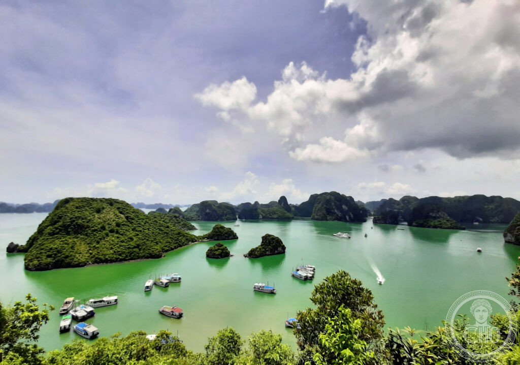
Ha Long Bay is experienced from the water, not from a single fixed viewpoint on land. The standard entry point is Ha Long City (Bãi Cháy pier), where the cruise boats depart; the bay becomes more spectacular as you move away from the city into the core zone of the World Heritage area (approximately 1 hour from the pier). The characteristic experience is the progressive revelation of the karst landscape as the boat moves deeper into the island clusters: the towers become more numerous, more varied in shape (needles, domes, elephant-heads, arches), and more closely spaced; the water colour shifts from grey-green near the city to deep emerald in the sheltered coves between the islands; the light is most dramatic at dawn and dusk when the towers are silhouetted against the sky.
The sea caves (hang) are the interior counterpart to the external tower landscape; Hang Đầu Gỗ (the “Wooden Stakes Cave”), Hang Sửng Sốt (“Surprise Grotto”), and the Thien Cung Grotto are the most visited; all are large limestone chambers with elaborate formations; the quality of the formations is uneven (some have been altered by the lighting installations), but the sheer scale of the largest chambers is remarkable. Kayaking through the low arch entrances (hồ, “lagoons”) that connect the sea to enclosed water basins inside the island ring-formations is the most intimate encounter with the geology; several islands have such interior lagoons, reachable only by kayak at low tide through a metre-high arch passage.
Practical information
- Boat tours: 1-day tours from Ha Long City (approximately $30–50 USD per person) visit 3–4 sites; 2-day/1-night cruises ($80–180 USD per person) are the minimum for a meaningful experience; 3-day/2-night cruises ($150–300 USD) include Bái Tử Long Bay and less-visited islands; quality varies significantly — the $40 budget boats are crowded; mid-range ($120–180) is the sweet spot; book through established operators (Indochina Junk, Bhaya Cruises, Paradise Cruises) for safety and quality; all licensed boats include life jackets and meals
- Getting there: Hanoi (Noi Bai Airport, HAN) is the hub for northern Vietnam; direct international flights from London (Vietnam Airlines, approximately 11 hours via Doha or Hong Kong), Frankfurt, Paris, Sydney (via Singapore); from Hanoi to Ha Long City by road transfer (approximately 3.5 hours, 165 km; most cruise operators include the transfer in the package; shuttle buses approximately $10 USD; private car approximately $40); seaplane from Noi Bai direct to Ha Long Bay takes 45 minutes (expensive, approximately $150 one-way)
- Best season: October–April for clear skies and calm seas; May–September is the typhoon season (storms can cancel boat departures; the water is warmer but the visibility is reduced); March–April combines best weather with pre-peak crowds; February (Tết holiday week) should be avoided as the bay is extremely crowded with domestic tourists
Getting there
Hanoi (HAN) international hub, 165 km west. Shuttle transfer to Bãi Cháy pier (~3.5h); seaplane option (~45 min, $150 one-way). All cruises include the pier transfer. GPS: 20.9101, 107.1839.
Nearby
- Bái Tử Long Bay — the extension of the Ha Long Bay UNESCO zone to the north-east, with the same karst geology but fewer visitors; the islands of Vân Đồn (including Quan Lan Island, with colonial-era churches and white sand beaches) and the Bái Tử Long National Park are accessible on 2–3 night cruises from Ha Long City or by speedboat from the Vân Đồn International Airport (opened 2018, with limited direct connections from Hanoi and Ho Chi Minh City); the absence of day-trip boats makes this zone significantly more tranquil
- Hạ Long City Viewpoints — for visitors on tight schedules (1-day visit without a cruise), the Ba Đèo Pass road between Ha Long City and Cam Pha gives high-level views over the bay; the Queen Cable Car (Hòn Gai side of the bay) rises to 404 metres and gives a panoramic bird’s-eye view of the karst island clusters (approximately $25 return); the viewpoint is best at sunrise or sunset
- Ninh Bình (Inland Ha Long Bay) — 100 km south-west of Hanoi; the “Inland Ha Long Bay” nickname refers to the Tràng An Landscape Complex (UNESCO WHS 2014, the only site in the world inscribed under both natural and cultural criteria simultaneously) — a flooded karst landscape similar to Ha Long Bay but on land, navigable by rowing boat through caves and rice paddies; nearby: Tam Cốc (“Three Caves”) valley and the ancient Vietnamese capital of Hoa Lư (10th century); easily combined with Ha Long Bay as a 4-day north Vietnam circuit
Sources
- Wikipedia, Ha Long Bay; Bái Tử Long Bay, accessed June 2026
- UNESCO, Ha Long Bay, WHS reference 672, inscribed 1994, extended 2000
- W.E. Frerichs, “Geology of Ha Long Bay,” in Journal of Asian Earth Sciences, 2000
- Vietnamese Ministry of Culture, Ha Long Bay National Heritage Documentation, 2020
Find it on the map
See this place and what’s around it →📷 Diventa un fotografo di Cultural Heritage Online
Condividi le tue foto dei luoghi: restano pubblicate con la tua firma come autore. Più vengono viste, più ti fai conoscere — e presto un concorso premierà le foto più apprezzate.
Accedi o registrati gratis per aggiungere una foto