
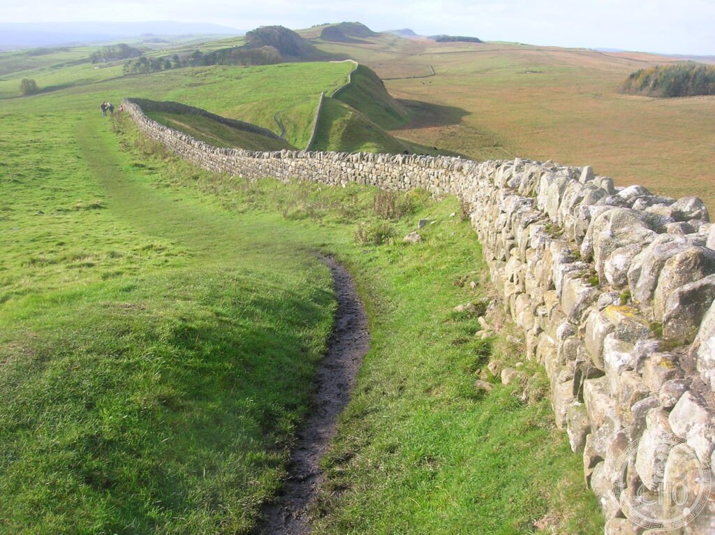
The largest Roman building project in Britain — a wall of stone and turf 117 kilometres long, 3 metres wide, and originally 5–6 metres tall, built in six years (122–128 AD) across the narrowest point of northern Britain from the Solway Firth to the Tyne estuary, manned by approximately 9,000 troops in 17 forts and 80 milecastles, and the northernmost permanent boundary of the Roman Empire in the west — a line of stone running across a landscape of wild moorland that can still be walked in its entirety today.
At a glance
Hadrian’s Wall is a Roman frontier fortification built across the north of Roman Britain (now northern England) between 122 and 128 AD, on the order of Emperor Hadrian (r. 117–138 AD), who visited Britain in 122 AD and initiated the project. The wall runs 117 km (73 Roman miles) from Wallsend (Segedunum) on the River Tyne in the east to Bowness-on-Solway on the Solway Firth in the west; the defended zone extended a further 40 km along the Cumbrian coast with a series of signal towers and small forts. The wall is a UNESCO World Heritage Site (inscribed 1987) as part of the “Frontiers of the Roman Empire” transnational serial WHS (which includes the Upper Germanic-Raetian Limes in Germany and the Antonine Wall in Scotland). The 117-km Hadrian’s Wall Path National Trail (a long-distance walking route along the wall) runs from coast to coast and is walkable in 7–9 days.
Key facts
- Construction: the wall was built primarily by three legions (II Augusta, VI Victrix, XX Valeria Victrix) plus auxiliary units; the building gangs each built specific sections identified by “centurial stones” (inscribed stones that name the centurion’s unit); the original plan (a wall 10 Roman feet — c. 3 metres — wide) was reduced mid-construction to 8 Roman feet (c. 2.5 metres), creating the “broad wall” and “narrow wall” sections visible in the archaeology
- The system: every Roman mile (1.48 km) a small fortlet (milecastle, MC) with a gate through the wall and space for 8–32 soldiers; between each pair of milecastles, two turrets (watchtowers) for signalling; 17 large auxiliary forts (up to 1,000 soldiers) at intervals along and behind the wall; to the north, a berm (clear space) and V-shaped ditch; to the south, a flat-bottomed military road (the Stanegate, earlier) and a second earthwork (the Vallum — a flat-bottomed ditch with mounds on both sides) that defined the military zone
- Housesteads (Vercovicium): the best-preserved fort on the wall and the most visited site; garrison of 800 auxiliary troops; the barracks, headquarters building, granaries, latrines (the best-preserved Roman latrines in Britain, with visible stone seats over a water channel), and hospital are all visible; the hilltop position gives views across the wall in both directions
- Vindolanda: a fort immediately south of the wall (pre-dating the wall, 1st–4th century AD) famous for the Vindolanda Tablets — over 1,000 thin wooden writing tablets preserved by anaerobic soil conditions; the tablets include military records, shopping lists, birthday invitations (including the earliest known document written by a woman in Latin, from Claudia Severa to Sulpicia Lepidina, c. 100 AD), and a request for more beer; the tablets are in the British Museum and the Vindolanda museum
- Sycamore Gap: the iconic tree — a single sycamore in the lowest point of the ridge, framed by the wall on both sides — was used as a location in the film Robin Hood: Prince of Thieves (1991); the tree was deliberately cut down in September 2023 (a suspect was charged with criminal damage); the stump remains; the gap itself is still the most photographed section of the wall
- Heritage: UNESCO World Heritage Site, Frontiers of the Roman Empire (transnational), inscribed 1987 (extended 2005, 2008)
- GPS (Housesteads Fort): 54.9932° N, 2.3338° W
History
When Hadrian arrived in Britain in 122 AD, the north of Roman Britain was unsettled; the Brigantes (the largest tribe in northern England) had been subdued but not pacified, and the area north of the Tyne-Solway line was held by tribes (the Selgovae, Votadini, Novantae, Damnonii) that Rome had never controlled. Hadrian’s decision to build a wall (rather than attempt further conquest, as Agricola had done in 83–84 AD by reaching as far north as Aberdeenshire) reflected a new imperial strategy of consolidation rather than expansion. The wall was not primarily a defensive barrier (it could not have stopped a determined mass crossing) but a control mechanism for trade, raiding, and movement — a customs frontier with formidable symbolic power.
The wall was garrisoned by auxiliary units (non-citizen troops from across the empire — there are inscriptions in Arabic, Frisian, Spanish, and Danubian languages) rather than legions. Inscriptions at Housesteads record a unit of Tungrians from modern Belgium; at Chesters, a cavalry unit from Spain; at Birdoswald, a unit from Dacia (Romania). The cosmopolitan garrison was supplied by a complex logistics system (the Vindolanda Tablets document supply requisitions for wine, grain, leather, and iron from across Britain and the Rhine provinces).
The wall was abandoned and reoccupied several times. The Antonine Wall (turf and timber, 60 km north in Scotland) replaced it briefly under Hadrian’s successor Antoninus Pius (c. 142 AD); the northern frontier oscillated between the two walls for a century before stabilising at Hadrian’s line in the 3rd century AD. The final withdrawal of Roman troops from Britain c. 410 AD left the wall garrisoned by local communities who maintained elements of Roman military organisation for decades. The wall was systematically quarried for stone from the medieval period onward; the major surviving sections (Housesteads, Cawfields, Steel Rigg) were preserved by their remoteness from settlement.
What you see
The best-preserved section of the wall runs from Chesters in the east to Birdoswald in the west, including the Steel Rigg/Winshields section (where the wall follows the dramatic ridge of the Whin Sill, a natural basalt escarpment that required no additional defensive ditch on the north side) and Housesteads Fort. The wall walk between Once Brewed (the national park visitor centre) and Housesteads (5 km east) is the most rewarding section for first-time visitors; it includes the Sycamore Gap (now notable for the absence of its tree), Milecastle 39, and the arrival at Housesteads through the south gate — a spatial experience that conveys the scale of the wall as a continuous structure in landscape.
The Great North Museum (Newcastle, 40 km east) has the best single display on Hadrian’s Wall, including a scale model of the complete system and original sculptural finds. Vindolanda Museum (adjacent to the Vindolanda fort, 3 km south of the wall at Bardon Mill) has the tablets and an extraordinary collection of preserved organic material (shoes, textiles, food remains) from the anaerobic layers; it is one of the finest Roman site museums in Britain.
Practical information
- Getting there: from Newcastle Central station by AD122 bus (seasonal, May–October, hourly along the wall from Newcastle to Carlisle via Hexham, Housesteads, and Birdoswald); by car from Newcastle (A69 west, 50 km to Housesteads), from Carlisle (A69 east, 40 km to Birdoswald); the Tyne Valley railway line (Newcastle–Carlisle) stops at Haltwhistle and Hexham, both with taxi or bus connections to the wall
- Walking the Wall Path: the 117-km National Trail is waymarked from Wallsend (Newcastle) to Bowness-on-Solway; 7–9 days for the full route; the central section (Once Brewed to Housesteads to Cawfields, 10–15 km) is the most dramatic and can be walked in a single day
- Key sites: Housesteads (EH, £8.50); Vindolanda (independent trust, £9); Chesters Fort and Museum (EH, £8.50); Birdoswald (EH, £8.50); English Heritage (EH) Explorer Pass covers all EH sites for a flat fee (£35 adult, 9 days)
Getting there
AD122 bus (seasonal) from Newcastle Central station along the wall to Carlisle. By car from Newcastle: A69 west (50 km to Housesteads). Tyne Valley railway (Newcastle–Carlisle) stops at Haltwhistle and Hexham. Nearest airports: Newcastle (NCL) 55 km east, Edinburgh (EDI) 100 km north. GPS (Housesteads): 54.9932, -2.3338.
Nearby
- Vindolanda — the Roman fort immediately south of the wall (pre-dating the wall, 1st–4th century AD); famous for the Vindolanda Tablets (over 1,000 thin wooden writing tablets, earliest Latin documents written by a woman, now in the British Museum); the museum has extraordinary preserved organic material; 3 km south of the wall at Bardon Mill
- Durham Cathedral and Castle — the finest Norman cathedral in England (begun 1093), with the tomb of Saint Cuthbert (from Lindisfarne) and the Venerable Bede; together with the castle, a UNESCO WHS inscribed 1986; 50 km south of Housesteads
- Lindisfarne (Holy Island) — the tidal island off the Northumberland coast where Aidan and Cuthbert established a Celtic Christian monastery in 635 AD (the source of the Lindisfarne Gospels, the greatest illuminated manuscript of the Anglo-Saxon period, now in the British Library); accessible on foot across the causeway at low tide; 80 km north-east of Housesteads
Sources
- Wikipedia, Hadrian’s Wall, accessed June 2026
- UNESCO, Frontiers of the Roman Empire, WHS reference 430, inscribed 1987 (extended 2005, 2008)
- David Breeze, Hadrian’s Wall, English Heritage, 2003 — the standard guidebook by the leading expert
- Robin Birley, The Vindolanda Writing Tablets, British Museum Press, 1994
Find it on the map
See this place and what’s around it →📷 Become a Cultural Heritage Online photographer
Share your photos of places: they stay published under your name as the author. The more they're seen, the more you get noticed — and soon a contest will reward the most appreciated photos.
Log in or sign up free to add a photoIs this page about you?
This page is read by travellers and heritage enthusiasts who find it on Google. Tell us how you are connected to this place and we will take it from there.