Chichen Itza — Yucatan
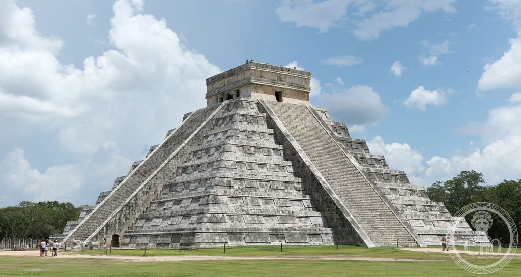
At the spring and autumn equinoxes, the setting sun projects a serpent of light and shadow down the staircase of El Castillo — the stepped pyramid of Chichen Itza whose 365 steps encode the solar year and whose orientation was calculated by Mayan astronomers a thousand years ago.
At a glance
Chichen Itza is a large pre-Columbian Maya city located in the Yucatan peninsula of Mexico, its most iconic structure being El Castillo (Temple of Kukulcan) — a 30-metre stepped pyramid at the site’s centre. The city was one of the largest Maya cities, occupying approximately 5 km², and was a major focal point of the Late Classic and Terminal Classic Maya periods (c. 600–900 AD) and the Early Postclassic (c. 900–1200 AD), when strong influences from central Mexico (associated with the Toltec culture) are evident in the site’s later buildings. Chichen Itza means “at the mouth of the well of the Itza” in Yucatec Maya, referring to the cenote (natural limestone sinkhole) that provided water. The site was inscribed as a UNESCO World Heritage Site in 1988 and was selected as one of the New Seven Wonders of the World in 2007.
Key facts
- Period: major construction c. 750–1200 AD; the city was occupied from at least 600 BC; abandoned as a political centre c. 1200 AD
- El Castillo (Temple of Kukulcan): 30 metres high; 91 steps on each of four faces plus the top platform = 365 steps total (the days of the solar year); at the spring and autumn equinoxes, the triangular shadows cast by the stepped terraces create the illusion of a serpent descending the north staircase
- Sacred Cenote: 60-metre diameter, 20 metres deep; used for sacrificial offerings; early 20th-century dredging recovered jade, gold, and human remains; connected to the main plaza by a 300-metre sacred road (sacbe)
- Great Ball Court: the largest ball court in Mesoamerica; 168 metres long, 70 metres wide; the game played here (pok-a-tok) may have had ritual or sacrificial significance; the acoustic properties allow a whisper at one end to be heard at the other
- Heritage: UNESCO World Heritage Site, inscribed 1988; New Seven Wonders of the World (2007)
- GPS: 20.6843° N, 88.5678° W
History
Chichen Itza was occupied from at least 600 BC as a small settlement centred on the two large cenotes (natural freshwater sinkholes) that provided water in an otherwise waterless limestone plain. The city reached its greatest importance during the Terminal Classic period (c. 800–950 AD), when Maya political structure in the southern lowlands was collapsing and northern Yucatan became the centre of Maya civilisation. The close integration of Toltec artistic and religious motifs — feathered serpents, warrior figures, tzompantli (skull racks), and chacmool sacrificial altars — with Late Classic Maya architectural forms suggests either a Toltec military presence or the adoption of Toltec symbolism by the local Itza rulers, a question still debated by archaeologists.
El Castillo was built over an earlier pyramid still contained inside it (accessible by a narrow passage); an interior chamber houses a red jaguar throne encrusted with jade. The observatory (El Caracol, “the snail” for its internal spiral staircase) was aligned to observe the movements of Venus, whose cycle was of great religious importance to the Maya. The Temple of the Warriors, with its hundreds of stone columns, and the adjacent Group of a Thousand Columns reveal a city of considerable scale and organisation. By approximately 1200 AD the city had declined as a regional power; the reasons are disputed but include possible drought, political conflict, and the rise of rival centres.
What you see
El Castillo is the defining image: a four-sided stepped pyramid with a temple on top, each face presenting a staircase flanked by feathered-serpent balustrades. The precision of its astronomical alignment — the equinox shadow-serpent effect is visible for about one hour around sunset on 21 March and 21 September — is achieved through the exact orientation and angle of the northwest corner and the north staircase; the staircase serves as a ramp of illumination that the terraces then shade progressively as the sun descends. Touching the pyramid is no longer permitted; the best viewing position is from a distance on the north or south side.
The Great Ball Court to the north-west is the most spatially impressive structure: an immense walled alley 168 metres long, the playing walls rising 8 metres, the temples at each end looming above. The carved reliefs on the lower walls show scenes from the ball game including the decapitation of a player, though whether the winner or loser was sacrificed is still debated. The acoustics — sound travels clearly from one end to the other — are a structural accident, not a deliberate design.
Practical information
- Location: near the town of Piste, Yucatan; 200 km from Cancun (2.5 hours), 120 km from Merida (1.5 hours)
- Hours: daily 8 am–5 pm; the site becomes very hot and crowded midday; arrive at opening for the coolest temperatures and fewest crowds
- Admission: MXN 571 (federal) + MXN 95 (state) = approximately USD 30 combined; foreigners pay the combined fee
- Climbing: climbing the pyramids is prohibited; the ropes that guide visitors through the main structures are extensive. El Castillo has been closed to climbers since 2006 following a visitor’s fatal fall
- Equinox: the shadow-serpent effect at the spring and autumn equinoxes draws enormous crowds (tens of thousands); avoid if you want a calm visit — the effect is visible for about a week either side of the equinox with moderate crowds
Getting there
By car or bus from Cancun (ADO first-class bus, approximately 2.5 hours) or Merida (ADO, approximately 2 hours). Day-trip tours from both cities are common. Nearest airport: Cancun International (CUN), 200 km east. GPS: 20.6843, -88.5678.
Nearby
- Cenote Ik Kil — a spectacular open cenote 3 km from Chichen Itza; swimming permitted in the turquoise water 26 metres below ground level; the classic tourist stop for post-ruins cooling off
- Uxmal — the best-preserved Puuc-style Maya city 78 km south-west of Merida; the Governor’s Palace is one of the finest buildings in Mesoamerica; UNESCO WHS; less crowded than Chichen Itza
- Merida — the Yucatan’s elegant colonial capital; the Cathedral (1598), the Paseo de Montejo, and the regional anthropology museum are the highlights; 120 km west
- Tulum — the only walled Maya city on the coast, 130 km south-east of Cancun; smaller and later (c. 13th–15th century AD) but dramatically positioned above the Caribbean
Sources
- Wikipedia, Chichen Itza, accessed June 2026
- Instituto Nacional de Antropología e Historia (INAH): inah.gob.mx
- UNESCO, Pre-Hispanic City of Chichen-Itza, WHS reference 483, inscribed 1988
- Linnea Wren and Peter Schmidt, “Elite Interaction during the Terminal Classic Period”, in Mesoamerica After the Classic Collapse, Cambridge University Press, 1991
Find it on the map
See this place and what’s around it →📷 Diventa un fotografo di Cultural Heritage Online
Condividi le tue foto dei luoghi: restano pubblicate con la tua firma come autore. Più vengono viste, più ti fai conoscere — e presto un concorso premierà le foto più apprezzate.
Accedi o registrati gratis per aggiungere una foto