Europe’s cultural walking routes offer direct access to architectural heritage, human history, and landscape that maps and museums cannot convey. From Riga’s Art Nouveau district to Rome’s ancient Via Appia and the sacred trail of the Camino de Santiago, this guide surveys the continent’s most significant routes for foot traffic and heritage discovery.
Riga: Modernist Architecture as Living Heritage
Albert Street (Alberta iela) in Riga represents the largest concentration of Art Nouveau buildings in any single city—over 750 registered structures built between 1890 and 1910. Walking these streets means encountering architectural modernism at the scale of an entire urban quarter, not isolated monuments. The route follows a grid of cobblestone blocks, each façade articulated with sculptural detail: masks, wreaths, garlands, and figural iconography cast from local sandstone.
Start at the intersection of Alberta iela and Dzirnavu, where the densest clusters begin. The walk proceeds northward through consecutive blocks, each building dated by plaque. Most remain residential or converted to galleries and cafés. The routing requires no museum entry; the street itself is the artifact. UNESCO inscribed Riga’s Art Nouveau district in 1997. The ensemble is pedagogical: Riga demonstrates how modernism penetrated civic life across Central Europe, distinct from the Art Nouveau of Paris or Vienna. Distance: 1–2 kilometres; duration: 1–1.5 hours unrushed. Seasonal: spring through early October. More routes and detailed walking cards are available on CHO’s interactive heritage map.
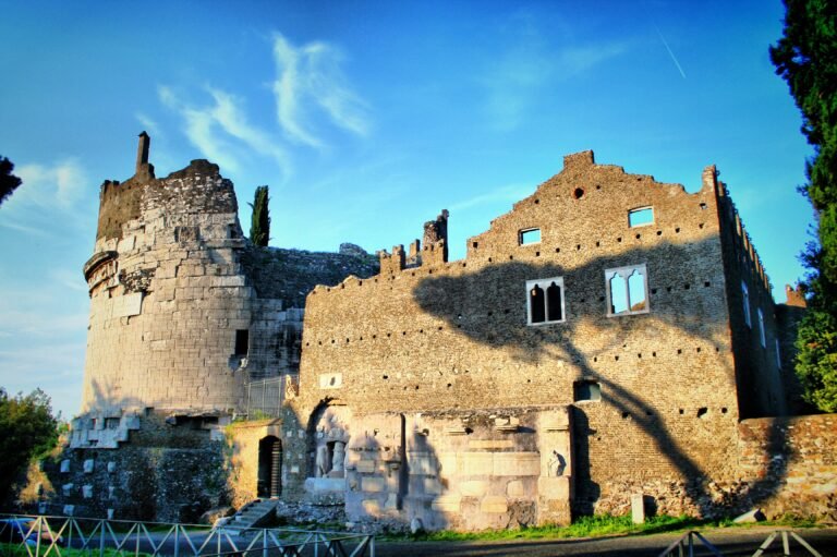
Rome: The Via Appia Antica and Layered Citizenship
The Appian Way, begun in 312 BC under the censor Appius Claudius Caecus, extended originally fifty-five kilometres southeast toward Capua. The section between Porta San Sebastiano and the modern suburb of Frattocchie (roughly ten kilometres, but commonly walked in sections of three to four kilometres) preserves Roman funerary monuments, Republican-era tombs, and ecclesiastical ruins across two thousand years of continuous use.
The walk opens at the Gate itself—still standing in medieval fortification, still marking the ancient boundary between city and countryside. South of the gate, the roadbed descends through villa grounds, pine groves, and archaeological sites largely untouched by modern construction. Monumental tombs punctuate the landscape: the cylindrical Tomb of Cecilia Metella (c. 30–10 BC), the Church of Domine Quo Vadis, pyramid-topped burial markers of freedmen. The route is pedestrian-friendly and mostly shaded. Best walked in stages. The Appian Way is neither a museum walk nor a hiking trail; it is a Roman citizen’s memorial landscape, read on foot as Romans did. Park access: free. Dedicated bike path available parallel to the ancient road.
Santiago de Compostela: The Sacred Trail Across Spain and France
The Camino de Santiago encompasses multiple routes converging at the Cathedral of Santiago de Compostela in northwestern Spain, but the most trafficked is the Camino Francés—roughly 780 kilometres from the French Pyrenees to the Atlantic coast. Modern pilgrims walk sections or the whole route over weeks, following medieval paths marked with yellow arrows and scallop-shell emblems.
The route carries genuine complexity: it traverses Spanish meseta (high plains) with minimal shelter, French vineyards and valleys, and coastal terrain. Medieval waypoint churches and monasteries still function as hospices. The Camino was recognized as a UNESCO World Heritage route in 1993. Most walkers undertake this as a structured multi-week expedition rather than a single-day outing. Infrastructure is robust: guidebooks, dedicated hostels, online planning tools. The trail is as much internal—psychological, spiritual, navigational—as it is geographic. Walking it in person reveals why it was a major pilgrimage axis for nine centuries.
Venice: Urban Navigation as Historical Archaeology
Venice lacks a “walking route” in the conventional sense—the entire city is a walking environment, but the logic of its layout is Byzantine and deliberately obscured. Canals replace roads. Bridges require strategy. No single itinerary captures the city, yet certain neighborhoods unlock medieval and Renaissance strata: the Dorsoduro district, the Ghetto (Venetian Jewish quarter, first of its kind in Europe, 1516), the lesser-known campo squares north of the Rialto.
Purposeful wandering—following small bridges toward the lagoon, doubling back when canals dead-end—teaches how Venice functioned as a maritime republic. The city itself was the economy; no separation existed between residential, commercial, and civic space. Walking without a single destination, noting the heights of buildings (suggesting old water levels and flood history), the names of campo squares (many named after professions: campo dei Mori, campo dei Fiubera) reveals social structure. This is not tourism but urban reading. Best undertaken without smartphone GPS; the disorientation is instructional.
Prague: Gothic Architecture and Occupation Layers
Prague’s Old Town Square and the route toward Prague Castle walk through concentrated medieval fabric, but the deeper route follows the line of Charles Bridge (begun 1357) and traces the city’s defensive history and architectural epochs. The Nerudova and Mostecká streets, leading uphill from the bridge to the castle compound, preserve Renaissance and Baroque shopfronts and noble houses largely unmodified since the eighteenth century.
Walking this route in sequence means encountering the layering of Czech, Germanic, and Austro-Hungarian settlement. The Charles Bridge itself carries thirty statues installed over three centuries, each narrating religious and civic authority. Prague Castle’s Romanesque and Gothic forms sit atop Celtic oppida settlements. The walking distance is modest (two to three kilometres), but the temporal depth—from Iron Age to 1968 Soviet occupation to post-1989 independence—is immense. The UNESCO-inscribed Old Town and Castle Precincts reward slow movement. Spring to autumn optimal.
Florence: Renaissance Coordination and Civic Geometry
Florence’s spatial logic—unlike Venice’s labyrinthine design or Rome’s archaeological stratification—reflects Renaissance mathematics and civic planning. Walking a prescribed route across the Ponte Vecchio, past the Uffizi Gallery, through the Piazza della Signoria to the Duomo and Baptistry traces the relationship between commercial wealth (Medici banking, guild power, wool trade) and monumental architecture.
The route is compact: 1–1.5 kilometres, accomplishable in an hour, yet it encompasses the visual transition from merchant city to cultural capital. The buildings—Brunelleschi’s dome, Orsanmichele (guild church), Palazzo Vecchio (civic power)—form a coherent narrative of fifteenth-century ambition. This walk is the most tourist-dense in Europe; solitude is not guaranteed. Yet it is indispensable because it demonstrates how a single city consciously constructed its own image as the center of Renaissance culture. Walking it in reverse, or at dusk, or in winter yields different perception. The route is weather-proof; arcaded passages and museum colonnades allow passage in rain.
Frequently Asked Questions
Which European walking route is best for first-time walkers?
Florence’s compact Renaissance circuit (1–1.5 kilometres) or Prague’s Charles Bridge and Old Town route suit newcomers. Both are walkable in a single afternoon with minimal elevation change. For longer commitment, the Camino de Santiago offers the most infrastructure and guidebook support, though some sections challenge fitness levels.
Are these routes walkable year-round?
Rome’s Via Appia is navigable year-round. Riga and Prague are optimal April to October; winter weather introduces ice and reduced daylight. The Camino Francés is walked most heavily spring through early autumn. Venice’s lagoon city requires no season adjustment, though summer crowds intensify. Florence functions in winter, though many museums reduce hours.
Do I need specialized hiking gear?
No. These are urban and near-urban routes. Standard walking shoes, weather-appropriate clothing, and a day pack for water and a camera suffice. The Camino de Santiago (multi-week) requires proper hiking boots and a backpack rated for 8–10 kilometres daily. The other five routes require only urban walking readiness.
Where can I find detailed walking maps and GPS coordinates?
UNESCO World Heritage site pages provide formal descriptions. CHO’s interactive heritage map aggregates GPS coordinates, opening hours, and editorial context for thousands of sites across these cities. Commercial guidebooks (Lonely Planet, Rough Guides) offer turn-by-turn routing. Open Street Map and AllTrails provide free alternatives.
Sources: UNESCO World Heritage Convention, Centre for the Study of the Estoric City (Prague); Cultural Heritage Online heritage map and city guides; ICOMOS European Network for cultural heritage documentation; via Appia Parco Archeologico official site; Cathedral of Santiago de Compostela; Riga Art Nouveau Museum; Florentine Renaissance Commission; Venetian UNESCO Criteria documentation.