
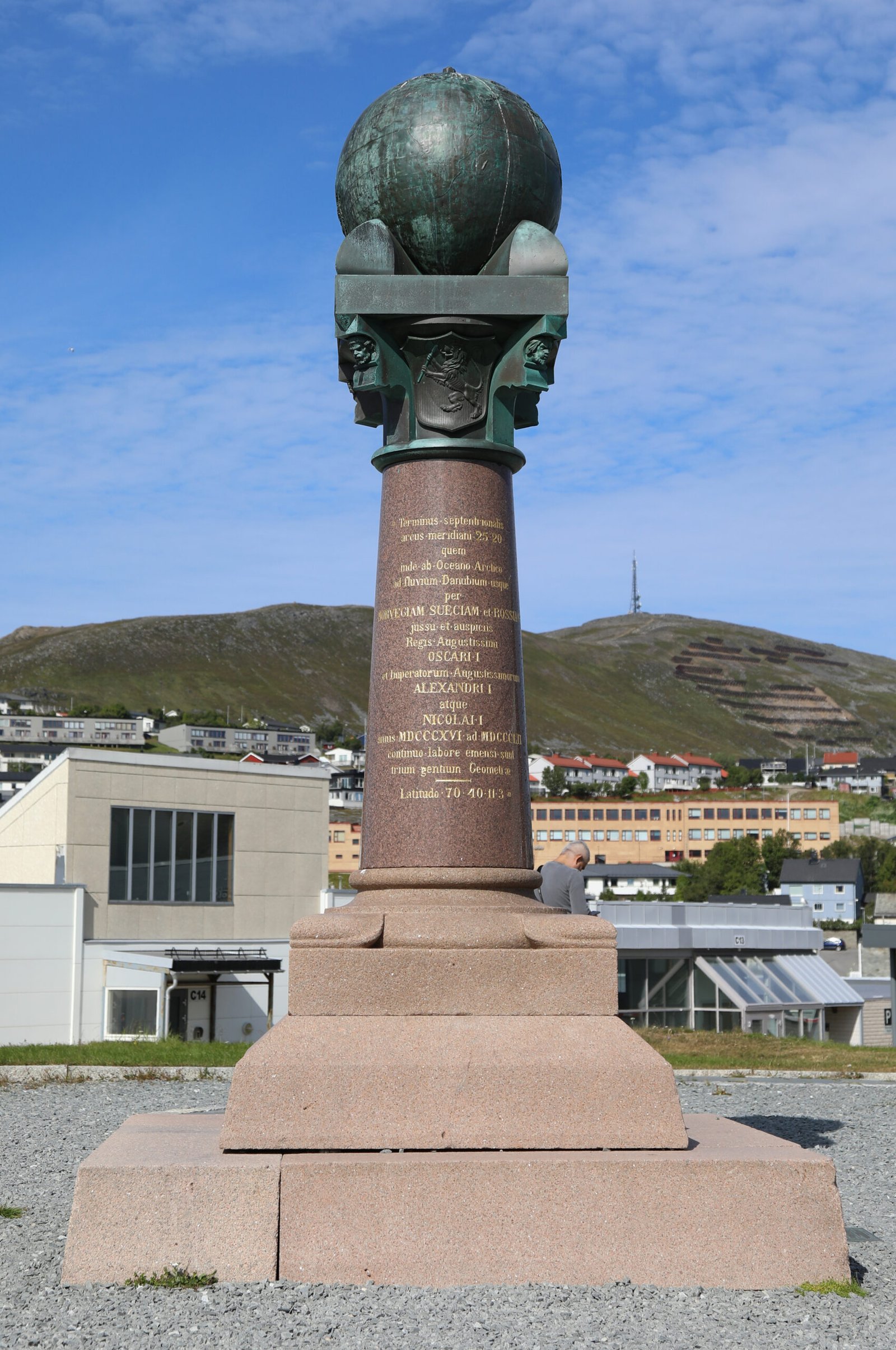
Not a building. Not a landscape. A scientific instrument 2,820 km long — a chain of 265 survey triangulation stations crossing 10 countries, built between 1816 and 1855 to measure the exact shape of the Earth, and still the most precise such measurement of its era.
At a glance
The Struve Geodetic Arc is one of the most unusual UNESCO World Heritage Sites in existence. It is not a single place but a distributed scientific instrument: a chain of triangulation survey stations running 2,820 km from Hammerfest in northern Norway to Izmail in Ukraine, spanning 10 countries and 25 degrees of latitude. Of the original 265 stations, 34 are specifically protected under the UNESCO designation. The Arc was constructed between 1816 and 1855 under the direction of the astronomer Friedrich Georg Wilhelm von Struve, whose goal was to determine the precise shape of the Earth — specifically to establish the exact length of a meridian arc, which was essential both for accurate mapping and for anchoring the emerging metric system. The measurement Struve obtained — the Earth’s polar flattening ratio of 1/299.13 — was not substantially improved upon until the 20th century.
Key facts
- UNESCO inscription: 2005 (criteria ii, iv, vi — outstanding example of scientific exchange; major stage in human history; association with scientific achievement of universal significance)
- Total length: 2,820 km (approximately 1,750 miles)
- Survey period: 1816–1855 CE
- Director: Friedrich Georg Wilhelm von Struve (1793–1864), Baltic German astronomer; based at the Pulkovo Observatory, St. Petersburg
- Original stations: 265 triangulation points
- UNESCO-protected points: 34 specifically listed stations in 10 countries
- Countries spanned: Norway, Sweden, Finland, Russia, Estonia, Latvia, Lithuania, Belarus, Moldova, Ukraine
- Northern terminus: Hammerfest, Norway (70°22’N) — the world’s northernmost town at time of survey
- Southern terminus: Staro-Nekrasivka (formerly Ismail), Ukraine (45°20’N) — near the Danube delta
- Station types: Stone pillars, holes drilled in bedrock, cellar wells, iron crosses — depending on local geology and resources
History
In the early 19th century, the exact shape of the Earth was a matter of live scientific debate. Newton had predicted that the Earth would be oblate — slightly flattened at the poles — but the precise degree of this flattening was unknown, and it mattered: navigation, mapping, and the emerging metric system of weights and measures all required it. The only way to determine it accurately was to measure a very long arc of the Earth’s surface along a single meridian and compare the result with mathematical predictions.
Friedrich von Struve, then director of the Dorpat (Tartu) Observatory in what is now Estonia, began the survey in 1816 with the section through the Baltic provinces of the Russian Empire. The project grew over four decades, eventually extending north through Sweden and Finland to the Norwegian coast and south through Russia and Ukraine to the Black Sea region. At the time, the territory of the survey passed through several different political entities: the Russian Empire, the Kingdom of Sweden-Norway, and the Grand Duchy of Finland — making the Arc one of the first major international scientific collaborations in history.
The survey technique was triangulation: surveyors identified a network of high points (hilltops, church towers, specially constructed wooden towers) visible to each other, measured the angles between them with great precision, and calculated the distances by geometry from a small number of directly measured baselines. The accuracy of the entire chain depended on the precision of these baseline measurements — and Struve’s team introduced innovations in baseline measurement that significantly reduced systematic error.
The result, published in 1857 as Arc du méridien de 25°20′ entre le Danube et la Mer Glaciale (Arc of the meridian of 25°20′ between the Danube and the Arctic Ocean), gave a polar flattening of 1/299.13. This figure remained the best available until the mid-20th century. It was used by cartographers worldwide and influenced the definition of the metre.
What you see
The 34 UNESCO-listed stations take very different physical forms depending on where they are located. At Hammerfest — the northernmost point and the most visited — there is a granite memorial column erected in the 19th century to mark the station. Other stations are granite pillars set in stone bases; some are simply holes drilled into exposed bedrock at hilltops or outcrops; a few are iron crosses cemented into rock. Several stations were placed in the cellars or foundations of buildings that have since been demolished.
The physical markers are modest by the standards of conventional heritage sites — their significance lies entirely in what they represent: the specific points where a team of surveyors, working decade after decade across an enormous territory, took the exact measurements that determined the shape of the planet. The landscape around each station is often more striking than the marker itself — windswept Norwegian coast at Hammerfest, forested Estonian hills, Ukrainian steppe near the Danube delta.
Several countries have created small museums or visitor centres near the most accessible stations. The Estonian station at Tartu (associated with the Tartu Old Observatory, where Struve worked) is the most developed for visitors. The Norwegian stations at Hammerfest and on the island of Magerøya (near North Cape) attract visitors already in the far north for other reasons.
Practical information
- Access: The 34 protected stations are spread across 10 countries; each requires individual travel planning
- Most accessible stations: Tartu (Estonia) — associated with the Old Observatory, open as museum; Hammerfest (Norway) — memorial column accessible in town centre
- Best single-country experience: Estonia has the highest density of accessible Struve Arc stations with visitor infrastructure
- Specialist interest: The Arc is of particular interest to geodesists, historians of science, and those interested in 19th-century exploration and measurement
- Combination travel: Most stations lie in regions with other major UNESCO WHS; planning around clusters of sites makes sense
Getting there
The northern terminus at Hammerfest (Norway) is accessible by road (E69/E6 north from Tromsø, approximately 6 hours), by coastal ferry (Hurtigruten), or by air (Hammerfest Airport, with connections to Tromsø and Oslo). Hammerfest is the gateway for visitors wishing to stand at the northernmost point of the Arc. The Tartu stations in Estonia are reached easily from Tallinn (3 hours by road) or by direct flights into Tartu Airport. The Ukrainian southern terminus, near Izmail on the Danube, is remote and difficult to access under current conditions.
Nearby
- North Cape (Nordkapp), Norway: 70 km from Hammerfest — iconic dramatic headland at 71°N, one of Europe’s northernmost accessible points
- Tartu Old Observatory, Estonia: Struve’s base for decades; 19th-century observatory buildings preserved and open to visitors
- Curonian Spit (Lithuania/Russia): UNESCO WHS; 98 km sand dune peninsula on the Baltic — near several Struve Arc stations in Lithuania
- Historic Centre of Tallinn, Estonia: UNESCO WHS; best-preserved medieval city in Northern Europe — practical hub for Estonian Arc stations
Sources
- UNESCO World Heritage Centre — Struve Geodetic Arc (List No. 1187)
- Wikipedia — Struve Geodetic Arc
- Struve Arc — struvearcnorway.no (Norwegian heritage authority)
Find it on the map
See this place and what’s around it →📷 Become a Cultural Heritage Online photographer
Share your photos of places: they stay published under your name as the author. The more they're seen, the more you get noticed — and soon a contest will reward the most appreciated photos.
Log in or sign up free to add a photo